


このアプリのYoutube動画がある場合はURLを送信してください。詳細 »
APPLICATION INFO - iPhoneアプリの詳細情報
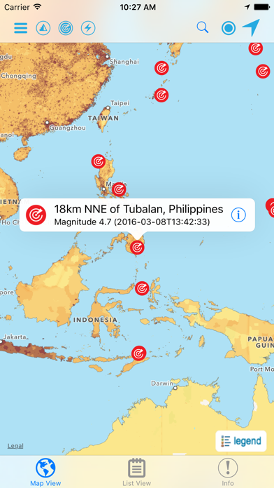
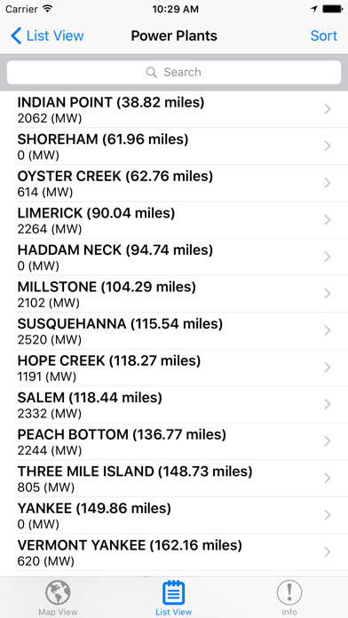
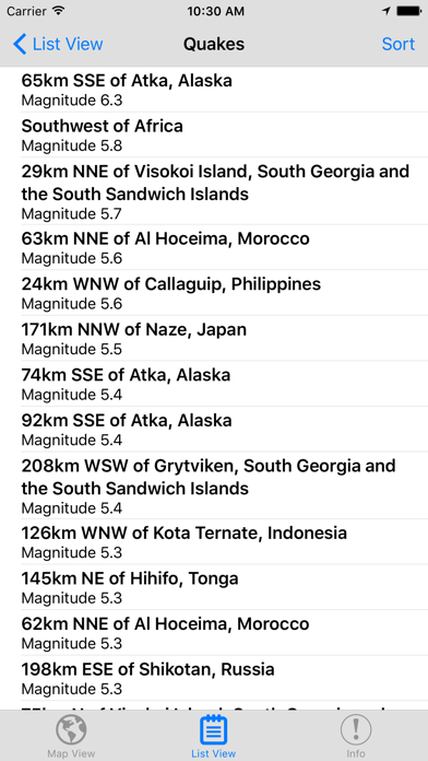
Hazards and Population Mapper (HazPop) is a free app that enables users to easily display recent natural hazard data in relationship to population, major infrastructure, and satellite imagery. Hazards data include the location of active fires over the past 48 hours; earthquake alerts over the past seven days; and yesterday′s air pollution data measured from space. The app shows the location of major dams and nuclear power plants and provides more detailed information and imagery for these facilities where available. By drawing a circle around a point or area of interest on the map, users can obtain an estimate of the total population and land area enclosed within.
Developed by the NASA Socioeconomic Data and Applications Center (SEDAC) operated by the Center for International Earth Science Information Network (CIESIN) at Columbia University, HazPop combines data and map layers from various sources including NASA's Land, Atmosphere Near real-time Capability for EOS (LANCE) and Global Imagery Browse Services (GIBS), the U.S. Geological Survey (USGS), and others using a variety of open Web mapping services. The custom population estimates are provided by the SEDAC Population Estimation Service (PES) based on SEDAC′s Gridded Population of the World, version 3 (GPWv3) data for 2005.
HazPop is designed to be used by disaster risk managers, humanitarian response organizations, public health professionals, journalists, and others needing a quick assessment of the potential dangers posed by a major hazardous event or developing emergency. For example, a disaster response agency can obtain a rough estimate of the population and major facilities near a recent earthquake as an input into response planning. Journalists or students can explore the location of recent wildfires relative to dense populations, roads, terrain, and water bodies. Due to the coarse resolution and varying quality of some of the data, HazPop is not intended to support in-depth risk assessment or location-specific response needs.
HazPop supports a number of other functions including: Monitoring regions around an area of interest, e.g. hazardous area prone to natural disasters, major infrastructure, or densely populated areas; Sorting dams, nuclear power plants, or earthquakes by proximity to your location or by their characteristics; Determining the distance from your location to any point on the map or between any two points on the map.
 このアプリはiPhone、iPadの両方に対応しています。
カテゴリー
辞書/辞典/その他
辞書/辞典/その他
リリース
2016/3/19
2016/3/19
更新
2016/10/18
2016/10/18
バージョン
1.3
1.3
言語
サイズ
11.3 MB
11.3 MB
条件
このバージョンの新機能
- Image layers, such as Population Density, AOD, and Fires, are now retrieved over secure HTTPS connection.
- Population estimates are now retrieved over secure HTTPS connection.
- Bug fix.
- Image layers, such as Population Density, AOD, and Fires, are now retrieved over secure HTTPS connection.
- Population estimates are now retrieved over secure HTTPS connection.
- Bug fix.
スクリーンショット - iPhone | iPad
スクリーンショット - iPhone | iPad
NASA の他のアプリ » もっと見る
» 目的別iPhoneアプリ検索
- 辞書 » 日本語対応の辞書 » 英和辞典
- 学習 » 英単語 » 英会話 » クイズで楽しく
- スケジュール » 管理 » Googleカレンダー


Google 翻訳
Google LLC無料
Video Searcher & Downloader– ネ..
Gang Li無料
写真コラージュ - 画像組み合わせ·Instagram用レイ..
Xi'an Button Software Technolo..無料
じしょ君 - 国語・英和辞典, 英語辞書 & 英語翻訳
Penzo無料
Lighto - 写真コラージュと画像加工・シェイプやマスク..
Xi'an Button Software Technolo..無料
ウィキグラフ
Hiroaki Towata無料
ウェブリオ英語翻訳アプリ
GRAS Group, Inc.無料
常用漢字筆順辞典【広告付き】
NOWPRODUCTION, CO.,LTD無料
コトバンク - 国語辞典・英和和英辞書・百科事典・用語集を横..
genesix無料
Yahoo!知恵袋 悩み相談できる Q&A チャット
Yahoo Japan Corp.無料


CatchApp新着アプリレビュー
 日本縦断てつどうの旅」")
様々な楽しみ方で運転士として成長していく鉄道運転士育成RPG「プラチナ・トレイン(プラトレ) 日本縦断てつどうの旅」
2016-05-17 00:00

日本語にはない英語発音のリスニングを楽しく学べる「発音どっち?英語リスニング 」
2014-12-20 12:00

指先の瞬発力が試されるカジュアルゲーム「早撃ちパニック」をリリース!
2014-12-08 15:21
新着アプリ動画
-
 ¥1500
¥1500
-
 ¥600
¥600
-
 ¥3000
¥3000