


このアプリのYoutube動画がある場合はURLを送信してください。詳細 »
APPLICATION INFO - iPhoneアプリの詳細情報
World atlas, world map and educational app for geography. Contains 240 countries and territories of the world with comprehensive economic and geopolitical data. Political maps with regional units (provinces), capitals and major cities included.
• Maps, flags and comprehensive data for 240 countries and territories of the world
• Interactive political world, continent and country maps
• Shaded relief layer for world and continent maps
• Geography quiz challenge for playful learning
• Country comparison and favorites
• Configurable world clock with time zone display
• World-explorer: the smallest, largest, wealthiest, and most populated countries of the world
• Selectable color themes for map display
• No online connection required
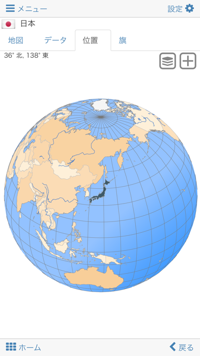
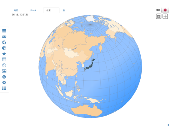
Explore the world through detailed continent and country offline maps. Whether Europe, Africa, Asia, Oceania, South and North America: maps of all continents and countries are included. Learn where each country in the world is located. View its position highlighted on a digital globe. Create your favorite color theme or choose from different color schemes for map display.
Do you know the flag of Mauritius? Yes? Perfect. Do you also know in which country the Mount Everest is located?
“World atlas & world map MxGeo Pro” Quiz helps you acquire a geographic literacy in a playful manner.
Choose from six geo guessing games:
• Test your knowledge about the capitals in the world
• Recognize the proper country flag based on the outline map
• Do you know the top-level domains of the world's countries
• Guess the highlighted country on the virtual globe
• Do you know the ISO countries codes of the world
• Do you know the mountains of the world
Each quiz offers seven regional variants: World, Europe, Africa, Asia, Oceania, South or North America.
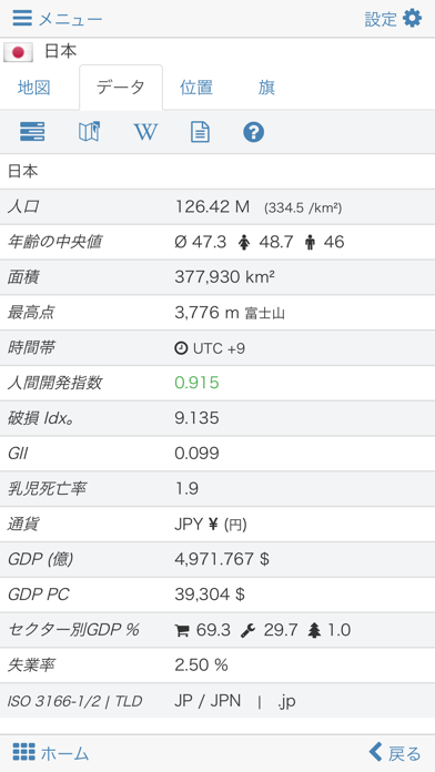
Geo learning app and educational game which is fun for everyone whether children, adults, seniors or teachers. Get ready for your next stay abroad while enjoying this great world almanac including time zones and statistical data, such as population growth, unemployment rate, average age, gross domestic product (GDP) by sector and other key figures. Or prepare for your next geography lesson with this genius digital world map. If not traveling our world atlas lets you explore the world just only virtually.
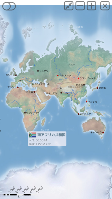
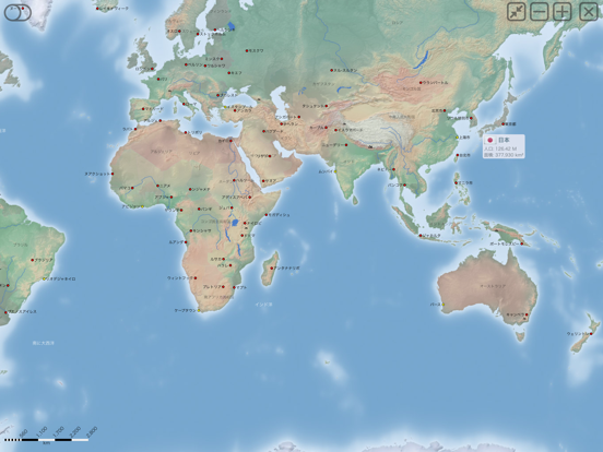
Have fun with our detailed political maps of the World, Europe, Asia, North America, Africa, Oceania and South America with all countries including regional units (provinces) and capitals and major cities.
• Maps, flags and comprehensive data for 240 countries and territories of the world
• Interactive political world, continent and country maps
• Shaded relief layer for world and continent maps
• Geography quiz challenge for playful learning
• Country comparison and favorites
• Configurable world clock with time zone display
• World-explorer: the smallest, largest, wealthiest, and most populated countries of the world
• Selectable color themes for map display
• No online connection required
Explore the world through detailed continent and country offline maps. Whether Europe, Africa, Asia, Oceania, South and North America: maps of all continents and countries are included. Learn where each country in the world is located. View its position highlighted on a digital globe. Create your favorite color theme or choose from different color schemes for map display.
Do you know the flag of Mauritius? Yes? Perfect. Do you also know in which country the Mount Everest is located?
“World atlas & world map MxGeo Pro” Quiz helps you acquire a geographic literacy in a playful manner.
Choose from six geo guessing games:
• Test your knowledge about the capitals in the world
• Recognize the proper country flag based on the outline map
• Do you know the top-level domains of the world's countries
• Guess the highlighted country on the virtual globe
• Do you know the ISO countries codes of the world
• Do you know the mountains of the world
Each quiz offers seven regional variants: World, Europe, Africa, Asia, Oceania, South or North America.
Geo learning app and educational game which is fun for everyone whether children, adults, seniors or teachers. Get ready for your next stay abroad while enjoying this great world almanac including time zones and statistical data, such as population growth, unemployment rate, average age, gross domestic product (GDP) by sector and other key figures. Or prepare for your next geography lesson with this genius digital world map. If not traveling our world atlas lets you explore the world just only virtually.
Have fun with our detailed political maps of the World, Europe, Asia, North America, Africa, Oceania and South America with all countries including regional units (provinces) and capitals and major cities.
 このアプリはiPhone、iPadの両方に対応しています。
▼現在のバージョンの平均評価
 25件の評価
25件の評価
▼すべてのバージョンの平均評価
25件の評価
25件の評価
カテゴリー
教育
教育
リリース
2016/7/13
2016/7/13
更新
2016/12/20
2016/12/20
バージョン
4.3
4.3
言語
サイズ
68.8 MB
68.8 MB
条件
このバージョンの新機能
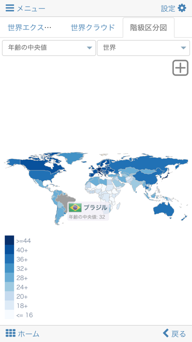
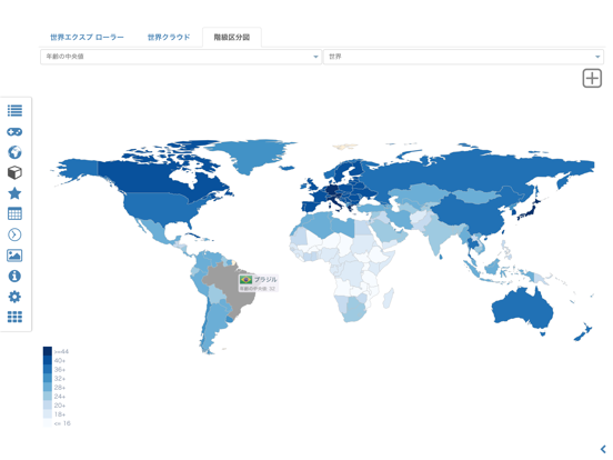
• Choropleth maps: GDP, area, HDI, population, ...
• World-Explorer new key figure: "average temperature"
• Update of time zone data
• Enhanced regional position maps
• Country data: time series and chart for average temperature and religious affiliations
• Choropleth maps: GDP, area, HDI, population, ...
• World-Explorer new key figure: "average temperature"
• Update of time zone data
• Enhanced regional position maps
• Country data: time series and chart for average temperature and religious affiliations
スクリーンショット - iPhone | iPad
スクリーンショット - iPhone | iPad
Hans-Peter Bahn の他のアプリ » もっと見る
» 目的別iPhoneアプリ検索
- 辞書 » 日本語対応の辞書 » 英和辞典
- 学習 » 英単語 » 英会話 » クイズで楽しく
- スケジュール » 管理 » Googleカレンダー


CatchApp新着アプリレビュー
 日本縦断てつどうの旅」")
様々な楽しみ方で運転士として成長していく鉄道運転士育成RPG「プラチナ・トレイン(プラトレ) 日本縦断てつどうの旅」
2016-05-17 00:00

日本語にはない英語発音のリスニングを楽しく学べる「発音どっち?英語リスニング 」
2014-12-20 12:00

指先の瞬発力が試されるカジュアルゲーム「早撃ちパニック」をリリース!
2014-12-08 15:21
新着アプリ動画
-
 ¥1500
¥1500

-
 ¥600
¥600
-
 ¥3000
¥3000