


このアプリのYoutube動画がある場合はURLを送信してください。詳細 »
APPLICATION INFO - iPhoneアプリの詳細情報
Tag Pilot extends a pilot's professional drone operation capabilities by providing a previously unavailable coupling of locations on a map with what the camera is seeing.
Tag Pilot gives DJI drone pilots knowledge of the surrounding terrain and allows them to navigate it safely while keeping track of tagged points of interest through both the map and camera interface.
Supports Phantom 3/4, Phantom 4 Pro, Inspire 1, Mavic Pro and Matrice 100/600 drones.
Key Features:
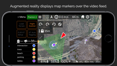
1. Uses Augmented Reality to show tags for map features superimposed on the live video feed.
2. Creates map tags for items that are tapped in the live video feed.
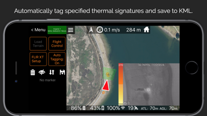
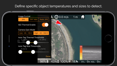
3. Automated Thermal Tagging for hot spots of a designated temperature range and size.
4. Image Footprint display shows where on the map the camera is currently looking.
5. Camera center point coordinate readout for precise object location.
6. Thermal Spot measurements.
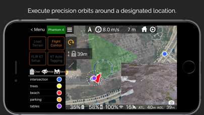
7. Automated Flight Modes: Orbit, Above Ground Level (AGL) Lock, Direct Flight.
8. In-App image and video review for quickly verifying and downloading your media in the field.
9. Import and Export locations to and from Google Earth and other applications with KML files.
10. In-App reviewable flight logs and easy KML exporting with AirDrop and email.
11. Detailed CSV log files that are compatible with Healthy Drones and other services.
12. Easy video and photo creation using the remote's built-in buttons.
Tag Pilot gives DJI drone pilots knowledge of the surrounding terrain and allows them to navigate it safely while keeping track of tagged points of interest through both the map and camera interface.
Supports Phantom 3/4, Phantom 4 Pro, Inspire 1, Mavic Pro and Matrice 100/600 drones.
Key Features:
1. Uses Augmented Reality to show tags for map features superimposed on the live video feed.
2. Creates map tags for items that are tapped in the live video feed.
3. Automated Thermal Tagging for hot spots of a designated temperature range and size.
4. Image Footprint display shows where on the map the camera is currently looking.
5. Camera center point coordinate readout for precise object location.
6. Thermal Spot measurements.
7. Automated Flight Modes: Orbit, Above Ground Level (AGL) Lock, Direct Flight.
8. In-App image and video review for quickly verifying and downloading your media in the field.
9. Import and Export locations to and from Google Earth and other applications with KML files.
10. In-App reviewable flight logs and easy KML exporting with AirDrop and email.
11. Detailed CSV log files that are compatible with Healthy Drones and other services.
12. Easy video and photo creation using the remote's built-in buttons.
 このアプリはiPhone、iPadの両方に対応しています。
カテゴリー
写真/ビデオ
写真/ビデオ
リリース
2016/11/4
2016/11/4
更新
2016/12/29
2016/12/29
バージョン
1.0.3
1.0.3
言語
サイズ
26.6 MB
26.6 MB
条件
このバージョンの新機能
Increased Phantom 4 Pro marker accuracy.
Increased Phantom 4 Pro marker accuracy.
スクリーンショット - iPhone | iPad
スクリーンショット - iPhone | iPad
Drones Made Easy の他のアプリ » もっと見る
» 目的別iPhoneアプリ検索
- 辞書 » 日本語対応の辞書 » 英和辞典
- 学習 » 英単語 » 英会話 » クイズで楽しく
- スケジュール » 管理 » Googleカレンダー


遠近感のある文字で写真を飾る!写真加工アプリPERSTEXT..
Canon Marketing Japan Inc.無料
Instagram
Instagram, Inc.無料
B612 - いつもの毎日をもっと楽しく
SNOW Corporation無料
YouTube - 公式アプリで動画と音楽
Google LLC無料
MixChannel
Donuts Co. Ltd.無料
LINE Camera - 写真編集、アニメーションスタンプ..
LINE Corporation無料
Aviaryのフォトエディタ
Aviary無料
Fotor画像編集加工•写真効果•補正•コラージュアプリ
Chengdu Everimaging Science an..無料
カメラ360 - あなただけのカメラアプリ!100以上のファ..
PinGuo Inc.無料
InstaMag - Photo Collage Maker
Fotoable, Inc.無料


CatchApp新着アプリレビュー
 日本縦断てつどうの旅」")
様々な楽しみ方で運転士として成長していく鉄道運転士育成RPG「プラチナ・トレイン(プラトレ) 日本縦断てつどうの旅」
2016-05-17 00:00

日本語にはない英語発音のリスニングを楽しく学べる「発音どっち?英語リスニング 」
2014-12-20 12:00

指先の瞬発力が試されるカジュアルゲーム「早撃ちパニック」をリリース!
2014-12-08 15:21
新着アプリ動画
-
 ¥1500
¥1500
-
 ¥600
¥600
-
 ¥3000
¥3000