


このアプリのYoutube動画がある場合はURLを送信してください。詳細 »
APPLICATION INFO - iPhoneアプリの詳細情報
i-EFIS simulates a modern glass cockpit for general aviation and provides the following features:
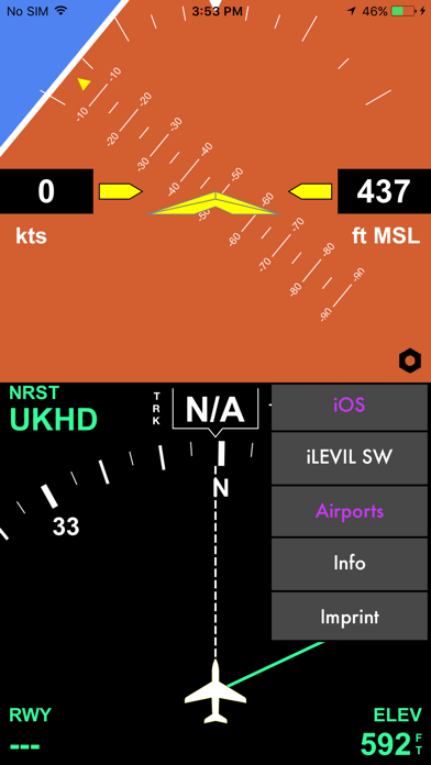
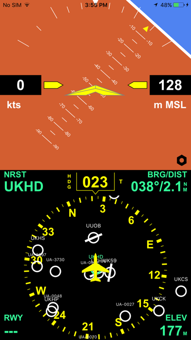
1. Display iOS iPhone and iPad sensor data: The attitude indicator is driven by the 3D MEMS chip, speed and altitude come from the internal or external GPS (only iOS devices with cellular connection have the integrated GPS!)
2. Or connect the iPhone to a iLEVIL „SW“, „AW“ or „Sport“ device (available at the LEVIL company or in many pilot shops) by WIFI device to get precise attitude and GPS data.
3. A 80 or 360 degree course rose (change with tap on airplane symbol)
4. Magnetic and True GPS track (display in white with with track line)
5. Magnetic or True Heading, heading data is provided by internal compass and is not always reliable.
6. iEFIS Pro version (simple upgrade via inapp purchase!) displays a worldwide airport database and always shows the bearing to the nearest airport from your position with distance, elevation and runway orientation of the main runway of that airport.
How to use i-EFIS
1. Tap the speed window to toggle speed units: km/h - mph - knots. Speed displayed is a GPS ground speed
2. Tap on the altitude window to switch from feet MSL to Meters MSL
3. Tap the course window to select the course mode: Magnetic Heading - True Heading - Magnetic Track - True Track. All GPS track modes are displayed in white, heading modes are yellow
4. Tap the airplane symbol to display either the full 360 degree course rose or a 80 degree segment
Pro version features
1. Tap on Runway orientation info to see runway length
2. Tap course window and slide up to hide attitude indicator and to switch to full screen mode
3. To calibrate magnetic heading tap course window to show "HDG" (Magnetic Heading), and slide finger left or right to set correct heading. Use airplane's compass as reference
4. To select a different airport than the nearest one simply tap on the airport symbol and the app will display the data for this airport
5. To go back to the nearest airport simply tap the empty space between the airports
Airport database in Pro version:
1. Switch Airport database on or off in settings.
2. Use the two finger pinch gesture to zoom airport map in/out
More cool Features coming!
 このアプリはiPhone、iPadの両方に対応しています。
カテゴリー
ナビゲーション
ナビゲーション
リリース
2017/4/7
2017/4/7
更新
2020/2/19
2020/2/19
バージョン
2.8
2.8
言語
サイズ
25 MB
25 MB
条件
このバージョンの新機能
- Corrected a bug that was responsible for wrong bearing indication when zooming into map
- Adjusted app for latest iOS version
- Corrected a bug that was responsible for wrong bearing indication when zooming into map
- Adjusted app for latest iOS version
スクリーンショット - iPhone | iPad
スクリーンショット - iPhone | iPad
airWORK aviation media UG の他のアプリ » もっと見る
» 目的別iPhoneアプリ検索
- 辞書 » 日本語対応の辞書 » 英和辞典
- 学習 » 英単語 » 英会話 » クイズで楽しく
- スケジュール » 管理 » Googleカレンダー


Yahoo!乗換案内
Yahoo Japan Corp.無料
Google マップ - ナビ、乗換案内
Google LLC無料
Yahoo!カーナビ
Yahoo Japan Corp.無料
乗換NAVITIME(乗換ナビタイム) - 運行情報や路線図..
NAVITIME JAPAN CO.,LTD.無料
Yahoo! MAP-ヤフーマップ
Yahoo Japan Corp.無料
乗換案内
Jorudan Co.,Ltd.無料
賃貸物件検索 SUUMO(スーモ)でお部屋探し
Recruit Co.,Ltd.無料
NAVITIME(乗換と地図の総合ナビ)
NAVITIME JAPAN CO.,LTD.無料
NAVITIMEドライブサポーター - カーナビ&渋滞情報&..
NAVITIME JAPAN CO.,LTD.無料
お部屋探しはライフルホームズ賃貸・マンション・不動産物件検索
LIFULL Co., Ltd無料


CatchApp新着アプリレビュー
 日本縦断てつどうの旅」")
様々な楽しみ方で運転士として成長していく鉄道運転士育成RPG「プラチナ・トレイン(プラトレ) 日本縦断てつどうの旅」
2016-05-17 00:00

日本語にはない英語発音のリスニングを楽しく学べる「発音どっち?英語リスニング 」
2014-12-20 12:00

指先の瞬発力が試されるカジュアルゲーム「早撃ちパニック」をリリース!
2014-12-08 15:21
新着アプリ動画
-
 ¥1500
¥1500
-
 ¥600
¥600
-
 ¥3000
¥3000