


このアプリのYoutube動画がある場合はURLを送信してください。詳細 »
APPLICATION INFO - iPhoneアプリの詳細情報
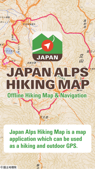
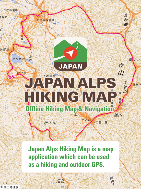
Japan Alps Hiking Map is a map application that can be used as a hiking / outdoor GPS.
By downloading data such as maps, routes, and place names that you planned in advance, you can check your current location with GPS even if you are in a no cellular signal area like mountains.
You can use the app when you do walking, running, cycling, trip, sightseeing, or any outdoor activities in Japan.
You can also read articles about hiking know-how in Japan, and hiking guides about Mt. Fuji, Kamakura Alps, and Karasawa. We are still working to add new articles and hiking guides.
[Characteristics]
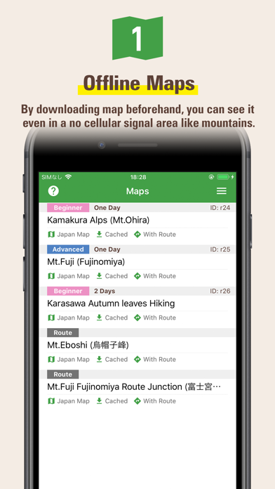
1) You can use the map offline
You can download and use the contour map of Japan which is offered by the Geospatial Information Authority of Japan.
In addition, "Footprints" which is the group of other hiker's GPS log will be displayed, so you can see at a glance where the people are actually walking (where the mountain path is).
Of course, since the place name data in English also will be downloaded, you can see the names of mountains and passes not on the contour map.
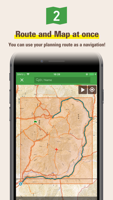
2) You can download route and map
You can download not only pre-prepared area maps but also our recommended routes and maps together.
You can also download routes and maps from a GPX file which you can get from any outdoor SNS like Yamareco.com.
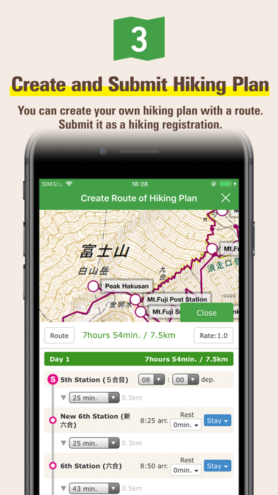
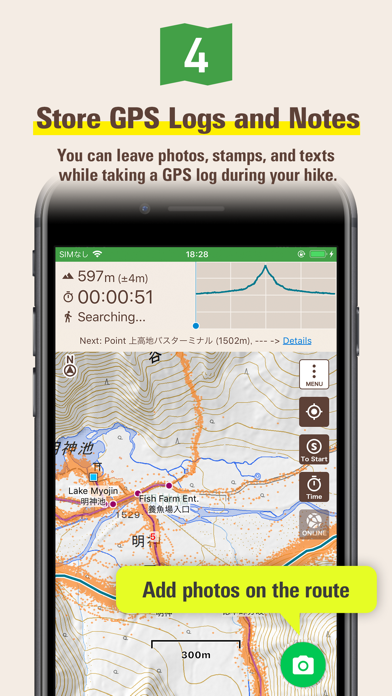
3) Store GPS logs while hiking
Once you start hiking, your phone will store the current location history as a GPS log.
GPS feature is only required the sky is open, so you can get current locations even if your phone is in Airplane Mode or you are in out of a cellular signal area.
[Important Notice]
Continued use of GPS running in the background can dramatically decrease battery life.
When hiking please be sure to bring a paper map and compass, spare battery and power cable.
You need to purchase a ticket to download maps for offline use. Even if you do not have a ticket, you can try all of the other functions such as GPS logging or online use.
"Footprints" function displays the actual walking traces for other hikers, but we cannot guarantees that the information is always accurate because it may include climbing routes, trails closed by the seasons, abolished roads etc.
When planning for mountain hiking, please be sure to check the latest information through other Web sites like Yamareco.com and local affiliates.
Place name data will be download after the installation. It may take around ten minutes to finish. You need to wait for download completion if you want to show all of the place name data in your map.
By downloading data such as maps, routes, and place names that you planned in advance, you can check your current location with GPS even if you are in a no cellular signal area like mountains.
You can use the app when you do walking, running, cycling, trip, sightseeing, or any outdoor activities in Japan.
You can also read articles about hiking know-how in Japan, and hiking guides about Mt. Fuji, Kamakura Alps, and Karasawa. We are still working to add new articles and hiking guides.
[Characteristics]
1) You can use the map offline
You can download and use the contour map of Japan which is offered by the Geospatial Information Authority of Japan.
In addition, "Footprints" which is the group of other hiker's GPS log will be displayed, so you can see at a glance where the people are actually walking (where the mountain path is).
Of course, since the place name data in English also will be downloaded, you can see the names of mountains and passes not on the contour map.
2) You can download route and map
You can download not only pre-prepared area maps but also our recommended routes and maps together.
You can also download routes and maps from a GPX file which you can get from any outdoor SNS like Yamareco.com.
3) Store GPS logs while hiking
Once you start hiking, your phone will store the current location history as a GPS log.
GPS feature is only required the sky is open, so you can get current locations even if your phone is in Airplane Mode or you are in out of a cellular signal area.
[Important Notice]
Continued use of GPS running in the background can dramatically decrease battery life.
When hiking please be sure to bring a paper map and compass, spare battery and power cable.
You need to purchase a ticket to download maps for offline use. Even if you do not have a ticket, you can try all of the other functions such as GPS logging or online use.
"Footprints" function displays the actual walking traces for other hikers, but we cannot guarantees that the information is always accurate because it may include climbing routes, trails closed by the seasons, abolished roads etc.
When planning for mountain hiking, please be sure to check the latest information through other Web sites like Yamareco.com and local affiliates.
Place name data will be download after the installation. It may take around ten minutes to finish. You need to wait for download completion if you want to show all of the place name data in your map.
 このアプリはiPhone、iPadの両方に対応しています。
カテゴリー
スポーツ
スポーツ
リリース
2017/8/9
2017/8/9
更新
2017/11/27
2017/11/27
バージョン
1.5
1.5
言語
サイズ
26.4 MB
26.4 MB
条件
このバージョンの新機能
Version 1.4
- iPhone X ready
- Add Hillshade to Japan map
- Update libraries
Version 1.4
- iOS11 ready
- Update libraries
Version 1.3
- Fixed time display bug which occurs if 24-Hour Time setting is off in settings app.
- Update libraries
Version 1.2
-
Version 1.4
- iPhone X ready
- Add Hillshade to Japan map
- Update libraries
Version 1.4
- iOS11 ready
- Update libraries
Version 1.3
- Fixed time display bug which occurs if 24-Hour Time setting is off in settings app.
- Update libraries
Version 1.2
-
スクリーンショット - iPhone | iPad
スクリーンショット - iPhone | iPad
YAMARECO INC. の他のアプリ » もっと見る
» 目的別iPhoneアプリ検索
- 辞書 » 日本語対応の辞書 » 英和辞典
- 学習 » 英単語 » 英会話 » クイズで楽しく
- スケジュール » 管理 » Googleカレンダー


YAMAP(ヤマップ) - GPS地図の定番アプリ!登山記録..
YAMAP無料
JRA-VAN競馬情報
JRA SYSTEM SERVICE CO.,LTD.無料
ゴルフスコア管理・ゴルフ動画 - ゴルフネットワーク プラス
YourGolf Online無料
ウゴトル
Ugotoru, Inc.無料
ゴルフスコアカード管理 - GDOスコア
GolfDigestOnline Inc.無料
Round1 お得なクーポン毎週配信!
Round1無料
日本相撲協会公式アプリ「大相撲」
DWANGO MOBILE Co., Ltd.無料
ゴルフ場予約 -GDO(ゴルフダイジェスト・オンライン)-
GolfDigestOnline Inc.無料
楽天GORA ゴルフ場予約
Rakuten Group, Inc.無料
ゴルフレッスン動画 - GolfTube(ゴルフチューブ)
Komorebi Inc.無料


CatchApp新着アプリレビュー
 日本縦断てつどうの旅」")
様々な楽しみ方で運転士として成長していく鉄道運転士育成RPG「プラチナ・トレイン(プラトレ) 日本縦断てつどうの旅」
2016-05-17 00:00

日本語にはない英語発音のリスニングを楽しく学べる「発音どっち?英語リスニング 」
2014-12-20 12:00

指先の瞬発力が試されるカジュアルゲーム「早撃ちパニック」をリリース!
2014-12-08 15:21
新着アプリ動画
-
 ¥1500
¥1500
-
 ¥600
¥600
-
 ¥3000
¥3000