


このアプリのYoutube動画がある場合はURLを送信してください。詳細 »
APPLICATION INFO - iPhoneアプリの詳細情報
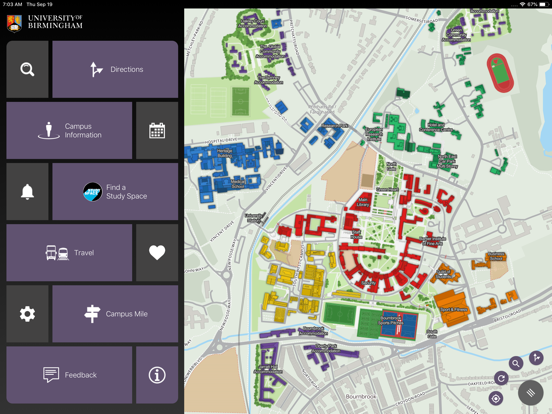
The UoB Campus map has been designed to help students, staff and visitors find their way around the University of Birmingham Edgbaston & Selly Oak Campus.
Building to building navigation, study space locations, café opening times and event updates have all been consolidated within the digital campus map.
Obtain useful travel advice on the various means of getting to and from the campuses including real-time bus and train information and supporting information on the location of cafés, shops and toilets.
In conjunction with the University's disabled access forum, the flexible routing capabilities have been used to ensure appropriate paths are selected for impaired mobility users. On occasions when paths or facilities (e.g. lifts or stairs) are closed, the system automatically takes this into account when calculating the best path.
Please use the feedback form within the settings menu to send us any issues, suggestions or comments to be considered in preparation for the next release.
Summary of Key Features:
Quick search: shows the location of any building or facility on campus with extra information options for key locations.
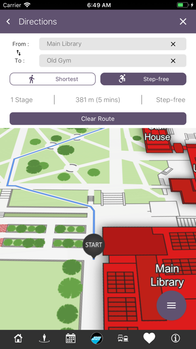
Directions: Navigation given to any location from any point on campus with the route plotted on the campus map. Stair-free routing can be selected prior to running a search, please access settings to adjust your preferences.
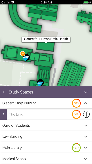
Study Space: Quickly identify the best locations to study on campus.
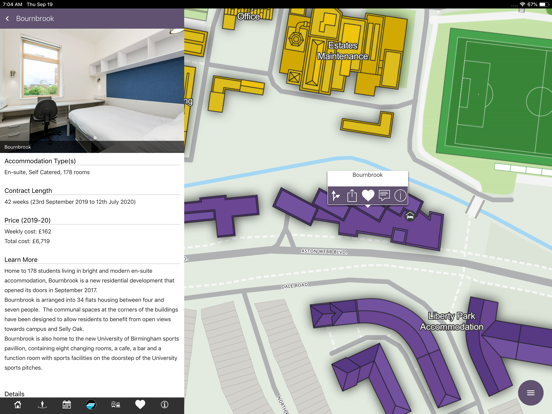
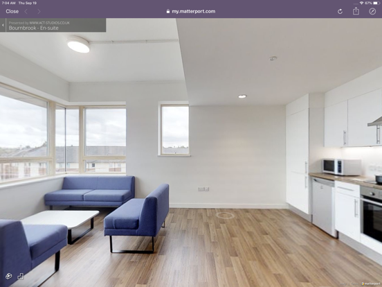
Additional Categories: Cafes, shops, toilets and bus stops can be selected and the relevant icons will be displayed on the map indicating their position. Further information such as opening times, photos and links to location web sites can be obtained by touching the icon.
Events: University event details can be viewed and listed by date, category and venue. Navigation is given to the venue hosting the event. Event Information is taken from the central University webpages.
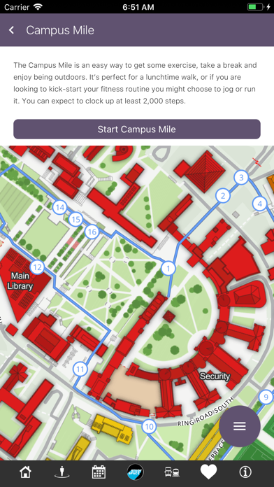
Campus Mile: The campus mile is an easy way to get some exercise, take a break and enjoy some exercise. It's perfect for a lunchtime walk, or if you are looking to kick-start your fitness routine you might choose to jog or run it. You can expect to clock up at least 2,000 steps.
Building to building navigation, study space locations, café opening times and event updates have all been consolidated within the digital campus map.
Obtain useful travel advice on the various means of getting to and from the campuses including real-time bus and train information and supporting information on the location of cafés, shops and toilets.
In conjunction with the University's disabled access forum, the flexible routing capabilities have been used to ensure appropriate paths are selected for impaired mobility users. On occasions when paths or facilities (e.g. lifts or stairs) are closed, the system automatically takes this into account when calculating the best path.
Please use the feedback form within the settings menu to send us any issues, suggestions or comments to be considered in preparation for the next release.
Summary of Key Features:
Quick search: shows the location of any building or facility on campus with extra information options for key locations.
Directions: Navigation given to any location from any point on campus with the route plotted on the campus map. Stair-free routing can be selected prior to running a search, please access settings to adjust your preferences.
Study Space: Quickly identify the best locations to study on campus.
Additional Categories: Cafes, shops, toilets and bus stops can be selected and the relevant icons will be displayed on the map indicating their position. Further information such as opening times, photos and links to location web sites can be obtained by touching the icon.
Events: University event details can be viewed and listed by date, category and venue. Navigation is given to the venue hosting the event. Event Information is taken from the central University webpages.
Campus Mile: The campus mile is an easy way to get some exercise, take a break and enjoy some exercise. It's perfect for a lunchtime walk, or if you are looking to kick-start your fitness routine you might choose to jog or run it. You can expect to clock up at least 2,000 steps.
 このアプリはiPhone、iPadの両方に対応しています。
カテゴリー
ナビゲーション
ナビゲーション
リリース
2019/1/22
2019/1/22
更新
2019/9/27
2019/9/27
バージョン
2.2.5
2.2.5
言語
サイズ
68.4 MB
68.4 MB
条件
このバージョンの新機能
Inclusion of travel disruption information, further refinements and bug fixes.
Inclusion of travel disruption information, further refinements and bug fixes.
スクリーンショット - iPhone | iPad
スクリーンショット - iPhone | iPad
Smart Networked Environments Ltd の他のアプリ » もっと見る
» 目的別iPhoneアプリ検索
- 辞書 » 日本語対応の辞書 » 英和辞典
- 学習 » 英単語 » 英会話 » クイズで楽しく
- スケジュール » 管理 » Googleカレンダー


Yahoo!乗換案内
Yahoo Japan Corp.無料
Google マップ - ナビ、乗換案内
Google LLC無料
Yahoo!カーナビ
Yahoo Japan Corp.無料
乗換NAVITIME(乗換ナビタイム) - 運行情報や路線図..
NAVITIME JAPAN CO.,LTD.無料
Yahoo! MAP-ヤフーマップ
Yahoo Japan Corp.無料
乗換案内
Jorudan Co.,Ltd.無料
賃貸物件検索 SUUMO(スーモ)でお部屋探し
Recruit Co.,Ltd.無料
NAVITIME(乗換と地図の総合ナビ)
NAVITIME JAPAN CO.,LTD.無料
NAVITIMEドライブサポーター - カーナビ&渋滞情報&..
NAVITIME JAPAN CO.,LTD.無料
お部屋探しはライフルホームズ賃貸・マンション・不動産物件検索
LIFULL Co., Ltd無料


CatchApp新着アプリレビュー
 日本縦断てつどうの旅」")
様々な楽しみ方で運転士として成長していく鉄道運転士育成RPG「プラチナ・トレイン(プラトレ) 日本縦断てつどうの旅」
2016-05-17 00:00

日本語にはない英語発音のリスニングを楽しく学べる「発音どっち?英語リスニング 」
2014-12-20 12:00

指先の瞬発力が試されるカジュアルゲーム「早撃ちパニック」をリリース!
2014-12-08 15:21
新着アプリ動画
-
 ¥1500
¥1500
-
 ¥600
¥600
-
 ¥3000
¥3000