


このアプリのYoutube動画がある場合はURLを送信してください。詳細 »
APPLICATION INFO - iPhoneアプリの詳細情報
The Adopt-a-Plot app is a geolocation-based app that displays the user's real-time position in relation to pre-loaded, or user-defined, map-based polygons, and it contains several user-friendly features. The app was originally designed to help forest maintenance citizen volunteers (of the Bay Ridge Civic Association, in Maryland), and for that purpose, it contains 105 pre-loaded geofenced “plots.” However, any user, worldwide, can easily enter a self-defined polygon and use the app for similar real-time relative geoposition visualization purpose.
The Adopt-a-Plot app uses the phone’s GPS to continually triangulate and display the user’s position. At the same time, the boundaries of the selected polygon are accurately displayed as a map overlay. The accuracy of the user’s location, in relation to plot boundaries, is limited only to the inherent accuracy of the phone’s GPS (typically about 15-30 feet). If needed, accuracy can be improved by pairing with an external GPS.
Users can simply scroll through a list of pre-loaded plots or create their own plot by inputting exact latitude and longitude coordinates. The app draws a red box around the desired area and displays the location of the user as a pulsing blue dot.
Included Features:
· Real-time positioning
· Drop down menu of currently programmed plots
· A coordinate input function
· Icons to zoom in and out of the map
· Accurate red border around the desired plot as map overlay
· Icons to switch the view between the user and the selected plot, and
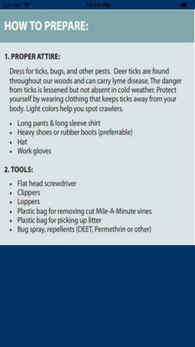
· An instructions menu, specific to Bay Ridge, Maryland, that describes how to cut the invasive species in forests along with safety precautions of going into the forest.
This app can drain phone batteries, so it is suggested to bring a portable charger or turn off the phone when not in use.
This app was developed in 2019, as a “Community Challenge Project” for the benefit of the Bay Ridge Civic Association, by a group of South River High School junior year STEM students: Ari Wasch, Samara Hatley, and Nick Merton. In particular, Ari wrote the code using Xcode for the Apple app and Android Studio for the Android app.
The Adopt-a-Plot app uses the phone’s GPS to continually triangulate and display the user’s position. At the same time, the boundaries of the selected polygon are accurately displayed as a map overlay. The accuracy of the user’s location, in relation to plot boundaries, is limited only to the inherent accuracy of the phone’s GPS (typically about 15-30 feet). If needed, accuracy can be improved by pairing with an external GPS.
Users can simply scroll through a list of pre-loaded plots or create their own plot by inputting exact latitude and longitude coordinates. The app draws a red box around the desired area and displays the location of the user as a pulsing blue dot.
Included Features:
· Real-time positioning
· Drop down menu of currently programmed plots
· A coordinate input function
· Icons to zoom in and out of the map
· Accurate red border around the desired plot as map overlay
· Icons to switch the view between the user and the selected plot, and
· An instructions menu, specific to Bay Ridge, Maryland, that describes how to cut the invasive species in forests along with safety precautions of going into the forest.
This app can drain phone batteries, so it is suggested to bring a portable charger or turn off the phone when not in use.
This app was developed in 2019, as a “Community Challenge Project” for the benefit of the Bay Ridge Civic Association, by a group of South River High School junior year STEM students: Ari Wasch, Samara Hatley, and Nick Merton. In particular, Ari wrote the code using Xcode for the Apple app and Android Studio for the Android app.
カテゴリー
ナビゲーション
ナビゲーション
リリース
2019/2/21
2019/2/21
更新
2019/5/15
2019/5/15
バージョン
1.1.1
1.1.1
言語
サイズ
8.4 MB
8.4 MB
条件
このバージョンの新機能
Minor bugs fixed.
Minor bugs fixed.
スクリーンショット
Bay Ridge Civic Association の他のアプリ » もっと見る
» 目的別iPhoneアプリ検索
- 辞書 » 日本語対応の辞書 » 英和辞典
- 学習 » 英単語 » 英会話 » クイズで楽しく
- スケジュール » 管理 » Googleカレンダー


Yahoo!乗換案内
Yahoo Japan Corp.無料
Google マップ - ナビ、乗換案内
Google LLC無料
Yahoo!カーナビ
Yahoo Japan Corp.無料
乗換NAVITIME(乗換ナビタイム) - 運行情報や路線図..
NAVITIME JAPAN CO.,LTD.無料
Yahoo! MAP-ヤフーマップ
Yahoo Japan Corp.無料
乗換案内
Jorudan Co.,Ltd.無料
賃貸物件検索 SUUMO(スーモ)でお部屋探し
Recruit Co.,Ltd.無料
NAVITIME(乗換と地図の総合ナビ)
NAVITIME JAPAN CO.,LTD.無料
NAVITIMEドライブサポーター - カーナビ&渋滞情報&..
NAVITIME JAPAN CO.,LTD.無料
お部屋探しはライフルホームズ賃貸・マンション・不動産物件検索
LIFULL Co., Ltd無料


CatchApp新着アプリレビュー
 日本縦断てつどうの旅」")
様々な楽しみ方で運転士として成長していく鉄道運転士育成RPG「プラチナ・トレイン(プラトレ) 日本縦断てつどうの旅」
2016-05-17 00:00

日本語にはない英語発音のリスニングを楽しく学べる「発音どっち?英語リスニング 」
2014-12-20 12:00

指先の瞬発力が試されるカジュアルゲーム「早撃ちパニック」をリリース!
2014-12-08 15:21
新着アプリ動画
-
 ¥1500
¥1500
-
 ¥600
¥600
-
 ¥3000
¥3000