


このアプリのYoutube動画がある場合はURLを送信してください。詳細 »
APPLICATION INFO - iPhoneアプリの詳細情報
KYFL @ ODISHA (Know Your Forest Location in Odisha) available in Apple’s
App Store ( Web URL: https://odishaforestlandinfo.in ) is a location service App
developed for Forest & Env. Department, Govt. of Odisha by ORSAC and FITGC Odisha,
utilizing the “Odisha RuRban4K Geo” Geospatial services. The App is developed by utilizing
georeferenced and geotagged administrative boundary and location data of “Odisha Rurban
4K Geo” and “OFMS” of Forest Department.
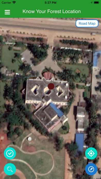
With respect to the Point of Interest (POI) of the user, the Mobile App gives the Geo-
Location of POI , name of the nearest Notified Forest Block and Approximate Distance from
the nearest Notified Forest Block and Forest Jurisdiction Details like Forest Circle, Division,
Range, Section and Beat. Along with these Forest specific information, the App also provides
the additional Land Revenue Information with respect to the Point of Interest (POI) like
name of District, Tehesil , CD Block, GP, Village, Khata number, Plot number, Owner’s
Name, Land Type and Area in Hectare , Police Station Details (Thana Name & Code and
Distance of Thana). .
There may be some inadvertent and inherent technical errors due to mobile devices and usual
mapping scale errors in the displayed data of the App, though best possible precautions are
taken to minimize the Geoinformatics errors. The data of this App is recommend only for
planning and management purpose. However for Land Revenue related measurements, field
DGPS Survey under standard operating procedures in presence of Revenue and Forest
Authorities is warranted.
This App is developed under 5T initiatives of Government of Odisha.
App Store ( Web URL: https://odishaforestlandinfo.in ) is a location service App
developed for Forest & Env. Department, Govt. of Odisha by ORSAC and FITGC Odisha,
utilizing the “Odisha RuRban4K Geo” Geospatial services. The App is developed by utilizing
georeferenced and geotagged administrative boundary and location data of “Odisha Rurban
4K Geo” and “OFMS” of Forest Department.
With respect to the Point of Interest (POI) of the user, the Mobile App gives the Geo-
Location of POI , name of the nearest Notified Forest Block and Approximate Distance from
the nearest Notified Forest Block and Forest Jurisdiction Details like Forest Circle, Division,
Range, Section and Beat. Along with these Forest specific information, the App also provides
the additional Land Revenue Information with respect to the Point of Interest (POI) like
name of District, Tehesil , CD Block, GP, Village, Khata number, Plot number, Owner’s
Name, Land Type and Area in Hectare , Police Station Details (Thana Name & Code and
Distance of Thana). .
There may be some inadvertent and inherent technical errors due to mobile devices and usual
mapping scale errors in the displayed data of the App, though best possible precautions are
taken to minimize the Geoinformatics errors. The data of this App is recommend only for
planning and management purpose. However for Land Revenue related measurements, field
DGPS Survey under standard operating procedures in presence of Revenue and Forest
Authorities is warranted.
This App is developed under 5T initiatives of Government of Odisha.
カテゴリー
ユーティリティ
ユーティリティ
リリース
2020/11/22
2020/11/22
更新
2020/12/22
2020/12/22
バージョン
v1.5.1
v1.5.1
言語
サイズ
16.7 MB
16.7 MB
条件
このバージョンの新機能
Slope and Aspect Added
Forest Location Updated
CRZ Fix
Slope and Aspect Added
Forest Location Updated
CRZ Fix
スクリーンショット
ODISHA SPACE APPLICATIONS CENTRE (ORSAC) の他のアプリ » もっと見る
» 目的別iPhoneアプリ検索
- 辞書 » 日本語対応の辞書 » 英和辞典
- 学習 » 英単語 » 英会話 » クイズで楽しく
- スケジュール » 管理 » Googleカレンダー


CatchApp新着アプリレビュー
 日本縦断てつどうの旅」")
様々な楽しみ方で運転士として成長していく鉄道運転士育成RPG「プラチナ・トレイン(プラトレ) 日本縦断てつどうの旅」
2016-05-17 00:00

日本語にはない英語発音のリスニングを楽しく学べる「発音どっち?英語リスニング 」
2014-12-20 12:00

指先の瞬発力が試されるカジュアルゲーム「早撃ちパニック」をリリース!
2014-12-08 15:21
新着アプリ動画
-
 ¥1500
¥1500

-
 ¥600
¥600
-
 ¥3000
¥3000