


このアプリのYoutube動画がある場合はURLを送信してください。詳細 »
APPLICATION INFO - iPhoneアプリの詳細情報
Wigemo is a Maps app with connection to Wikipedia for iPhone, iPod Touch, iPad and Apple Watch.
Save and manage your favorite places and locations, save the places you want to visit, plan your next vacation, manage the geo caches you've found or want to find, find sights and much more.
Thanks to the connection to Wikipedia, you can easily read the Wikipedia article for the places.
Import places from GPX, KML or CSV files, from photos, web sites, from Booking (App and Web), Google Maps, Apple Maps, Yelp...
The app can automatically notify you if you approach certain saved locations, so you won't miss them.
Supported Maps
- Apple Maps (Standard, Satellite, Hybrid, Flyover, 3D Buildings),
- OpenTopoMap (Topographical map)
- Mapbox Maps via additional subscription (Streets, Outdoors, Light, Dark, Satellite, Satellite+Street). These high-quality maps are much more detailed (especially in nature, hiking trails, paths, outdoor activity etc.)
- Any number of additional raster maps can be included via additional "tile server" features (with an additional one-time purchase)
Search
- POI search via Apple Maps
- Search via Wikipedia
- Search for search terms
- Search for coordinates
- Search for places nearby certain reference locations
- Filter search results by categories
Details for places
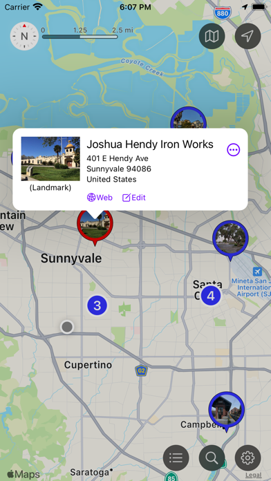
- Display Web page or Wikipedia article of the place
- Phone number (incl. option to call the number)
- Address
- Visited status
- Category
- Color (used for the pins on the map)
- photo
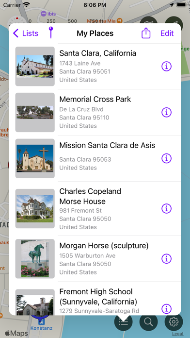
Manage Places
- Places can be saved in lists
- Move places from one list to another
- Show or hide lists and their places on the Map (so you can concentrate on those places you are currently interested in)
- Places can be show/hidden based on their "visited" status
- There are multiple styles available for the pins on the Map (a simple disc, icon of the category, photo, different sizes)
Import Places
- You can import geo locations from other Apps via "share" feature, via AirDrop, from cloud service, from the photo album, the address book
- Supports photos (with GPS coordinates), Web addresses, GPX, KML, and CSV files, geo coordinates
- Recognized are many web sites with geo tags, embedded google maps, the booking web site, Wikipedia, Yelp etc.
- Apps which can share suitable data are for example the Booking App, Apple-Maps, Web-Browser
Export Places
- Places can be exported as GPX, KML, or CSV file (individually, whole lists or even all lists at once)
- You can share the data with other Apps ur export them to cloud services
- iCloud Sync can be used to synchronize the places between multiple iOS devices
- You can also sync the places between iPhone and Apple Watch
Routes
- A route stores a path from A to B, including additional information and notes for waypoints
- Import routes from GPX/KML files
- Create routes manually
- Use the "directions" feature to create routes
- Save and organise any number or routes
- Display routes on the map
Other Features
- The App can send a notification if the user approaches saved places
- A crosshair with geo coordinates can be shown on the Map
- A scale allows to estamate distances on the map
Apple Watch
- The App on the Apple Watch supports the search via Wikipedia
- Places can be organized in lists
- Places can be shown/hidden on the map (based on lists, and visited status)
- Places can be saved on the watch
- The Watch App can run independently from the iPhone App.
Note: The App supports even older iOS releases back to iOS 12. But the full feature set requires iOS 14 and newer. Only search features relying on Apple's map services can be limited under iOS 12 or 13, the search via Wikipedia will work under all iOS releases. e.g. filtering search results by POI category requires at least iOS 13. The search for POIs near a certain location requires iOS 14 and later.
EULA: https://www.apple.com/legal/internet-services/itunes/dev/stdeula/
Save and manage your favorite places and locations, save the places you want to visit, plan your next vacation, manage the geo caches you've found or want to find, find sights and much more.
Thanks to the connection to Wikipedia, you can easily read the Wikipedia article for the places.
Import places from GPX, KML or CSV files, from photos, web sites, from Booking (App and Web), Google Maps, Apple Maps, Yelp...
The app can automatically notify you if you approach certain saved locations, so you won't miss them.
Supported Maps
- Apple Maps (Standard, Satellite, Hybrid, Flyover, 3D Buildings),
- OpenTopoMap (Topographical map)
- Mapbox Maps via additional subscription (Streets, Outdoors, Light, Dark, Satellite, Satellite+Street). These high-quality maps are much more detailed (especially in nature, hiking trails, paths, outdoor activity etc.)
- Any number of additional raster maps can be included via additional "tile server" features (with an additional one-time purchase)
Search
- POI search via Apple Maps
- Search via Wikipedia
- Search for search terms
- Search for coordinates
- Search for places nearby certain reference locations
- Filter search results by categories
Details for places
- Display Web page or Wikipedia article of the place
- Phone number (incl. option to call the number)
- Address
- Visited status
- Category
- Color (used for the pins on the map)
- photo
Manage Places
- Places can be saved in lists
- Move places from one list to another
- Show or hide lists and their places on the Map (so you can concentrate on those places you are currently interested in)
- Places can be show/hidden based on their "visited" status
- There are multiple styles available for the pins on the Map (a simple disc, icon of the category, photo, different sizes)
Import Places
- You can import geo locations from other Apps via "share" feature, via AirDrop, from cloud service, from the photo album, the address book
- Supports photos (with GPS coordinates), Web addresses, GPX, KML, and CSV files, geo coordinates
- Recognized are many web sites with geo tags, embedded google maps, the booking web site, Wikipedia, Yelp etc.
- Apps which can share suitable data are for example the Booking App, Apple-Maps, Web-Browser
Export Places
- Places can be exported as GPX, KML, or CSV file (individually, whole lists or even all lists at once)
- You can share the data with other Apps ur export them to cloud services
- iCloud Sync can be used to synchronize the places between multiple iOS devices
- You can also sync the places between iPhone and Apple Watch
Routes
- A route stores a path from A to B, including additional information and notes for waypoints
- Import routes from GPX/KML files
- Create routes manually
- Use the "directions" feature to create routes
- Save and organise any number or routes
- Display routes on the map
Other Features
- The App can send a notification if the user approaches saved places
- A crosshair with geo coordinates can be shown on the Map
- A scale allows to estamate distances on the map
Apple Watch
- The App on the Apple Watch supports the search via Wikipedia
- Places can be organized in lists
- Places can be shown/hidden on the map (based on lists, and visited status)
- Places can be saved on the watch
- The Watch App can run independently from the iPhone App.
Note: The App supports even older iOS releases back to iOS 12. But the full feature set requires iOS 14 and newer. Only search features relying on Apple's map services can be limited under iOS 12 or 13, the search via Wikipedia will work under all iOS releases. e.g. filtering search results by POI category requires at least iOS 13. The search for POIs near a certain location requires iOS 14 and later.
EULA: https://www.apple.com/legal/internet-services/itunes/dev/stdeula/
 このアプリはiPhone、iPadの両方に対応しています。
カテゴリー
旅行
旅行
リリース
2022/1/30
2022/1/30
更新
2023/1/26
2023/1/26
バージョン
1.8
1.8
言語
サイズ
52.1 MB
52.1 MB
条件
このバージョンの新機能
- "Map Overlays" do now support the MapBox maps as well. Which means this feature can be now used with all maps styles and map types without any restrictions.
- Under iOS 16 and later it is now also possible to customize the colors/contrast of the Standa
- "Map Overlays" do now support the MapBox maps as well. Which means this feature can be now used with all maps styles and map types without any restrictions.
- Under iOS 16 and later it is now also possible to customize the colors/contrast of the Standa
スクリーンショット - iPhone | iPad
スクリーンショット - iPhone | iPad
Alexander Clauss の他のアプリ » もっと見る
» 目的別iPhoneアプリ検索
- 辞書 » 日本語対応の辞書 » 英和辞典
- 学習 » 英単語 » 英会話 » クイズで楽しく
- スケジュール » 管理 » Googleカレンダー


Google Earth
Google LLC無料
じゃらん
Recruit Co.,Ltd.無料
楽天トラベル
Rakuten Travel Inc.無料
ホテルズドットコム - 国内・海外のホテルをお得に予約
Hotels.com無料
ANA
ANA (All Nippon Airways)無料
アトラクション待ち時間
NORIHIKO HAYASAKA無料
エクスペディア - ホテル予約、格安航空券&現地ツアー予約
Expedia, Inc.無料
まっぷるリンク
Shobunsha Publications, Inc.無料
週刊じゃらん -旬の観光・グルメ・宿情報をまとめ読み
Recruit Co.,Ltd.無料
ホテル予約 厳選20社 旅比較ねっと
BIGLOBE Inc.無料


CatchApp新着アプリレビュー
 日本縦断てつどうの旅」")
様々な楽しみ方で運転士として成長していく鉄道運転士育成RPG「プラチナ・トレイン(プラトレ) 日本縦断てつどうの旅」
2016-05-17 00:00

日本語にはない英語発音のリスニングを楽しく学べる「発音どっち?英語リスニング 」
2014-12-20 12:00

指先の瞬発力が試されるカジュアルゲーム「早撃ちパニック」をリリース!
2014-12-08 15:21
新着アプリ動画
-
 ¥1500
¥1500
-
 ¥600
¥600
-
 ¥3000
¥3000