


このアプリのYoutube動画がある場合はURLを送信してください。詳細 »
APPLICATION INFO - iPhoneアプリの詳細情報
LogGPS is a GPS data logger recorder utility that saves all GPS data when you press the 'Save' button. The saved data includes notes, date and time, longitude, latitude, altitude, horizontal accuracy, vertical accuracy, speed, course, heading, and heading accuracy. The notes are not cleared between saves so you may save multiple data points with the same notes or you may manually clear or edit the notes between saves.
LogGPS is an ideal application to use for remote GPS data gathering with the intent of importing the GPS data into another application. LogGPS does not do any direct mapping and therefor it does not require any network access. Because it does not require network access and currently does not record in the background it is fast and very easy on battery life.
LogGPS now has a Big Button mode that make the entire screen a 'Save' button. Once activated, touching anywhere on the screen saves the current GPS location. This mode was designed specifically for city administrations to log locations for follow-up code enforcement inspections. Big Button mode is cancelled by exiting LogGPS with the Home button.
it is possible to show any saved location using a map application. Of course, it only works if you have network access.
There is also a 'return to location' function. After selecting a saved location, select the 'Return To' button and a new view will appear that shows the course, bearing, distance, and time to return to the saved location.
The user may view all saved GPS readings. Individual readings can be deleted and notes edited.
Clicking ‘Export’ allows sharing the collected data as a comma separated (CSV) text file and a GPX file. Data is exported without any transformations (metric units and UTC) regardless of the display settings.
Once the data is exported and a file selected, it can be emailed, sent to other applications, saved in a common file area, etc. using the 'Share' button
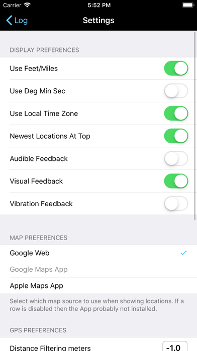
Settings in the Apple Settings application allow:
- Metric or US Customary Units for displayed distance.
- Local device time or UTC for displayed time.
- DMS or fractional degrees for displayed latitude and longitude.
- Sorting newest readings at top or bottom.
- Selection of mapping application (Apple Maps, Google Maps, Google Web.)
LogGPS is an ideal application to use for remote GPS data gathering with the intent of importing the GPS data into another application. LogGPS does not do any direct mapping and therefor it does not require any network access. Because it does not require network access and currently does not record in the background it is fast and very easy on battery life.
LogGPS now has a Big Button mode that make the entire screen a 'Save' button. Once activated, touching anywhere on the screen saves the current GPS location. This mode was designed specifically for city administrations to log locations for follow-up code enforcement inspections. Big Button mode is cancelled by exiting LogGPS with the Home button.
it is possible to show any saved location using a map application. Of course, it only works if you have network access.
There is also a 'return to location' function. After selecting a saved location, select the 'Return To' button and a new view will appear that shows the course, bearing, distance, and time to return to the saved location.
The user may view all saved GPS readings. Individual readings can be deleted and notes edited.
Clicking ‘Export’ allows sharing the collected data as a comma separated (CSV) text file and a GPX file. Data is exported without any transformations (metric units and UTC) regardless of the display settings.
Once the data is exported and a file selected, it can be emailed, sent to other applications, saved in a common file area, etc. using the 'Share' button
Settings in the Apple Settings application allow:
- Metric or US Customary Units for displayed distance.
- Local device time or UTC for displayed time.
- DMS or fractional degrees for displayed latitude and longitude.
- Sorting newest readings at top or bottom.
- Selection of mapping application (Apple Maps, Google Maps, Google Web.)
 このアプリはiPhone、iPadの両方に対応しています。
カテゴリー
ナビゲーション
ナビゲーション
リリース
2011/1/18
2011/1/18
更新
2020/3/31
2020/3/31
バージョン
4.0.1
4.0.1
言語
英語
英語
サイズ
16.7 MB
16.7 MB
条件
iPhone、iPod touch および iPad 互換 iOS 4.2 以降が必要
iPhone、iPod touch および iPad 互換 iOS 4.2 以降が必要
このバージョンの新機能
- Minor bug fixes and code refactoring.
- Minor bug fixes and code refactoring.
スクリーンショット - iPhone | iPad
スクリーンショット - iPhone | iPad
Fairwinds Software の他のアプリ » もっと見る
» 目的別iPhoneアプリ検索
- 辞書 » 日本語対応の辞書 » 英和辞典
- 学習 » 英単語 » 英会話 » クイズで楽しく
- スケジュール » 管理 » Googleカレンダー


Yahoo!乗換案内
Yahoo Japan Corp.無料
Google マップ - ナビ、乗換案内
Google LLC無料
Yahoo!カーナビ
Yahoo Japan Corp.無料
乗換NAVITIME(乗換ナビタイム) - 運行情報や路線図..
NAVITIME JAPAN CO.,LTD.無料
Yahoo! MAP-ヤフーマップ
Yahoo Japan Corp.無料
乗換案内
Jorudan Co.,Ltd.無料
賃貸物件検索 SUUMO(スーモ)でお部屋探し
Recruit Co.,Ltd.無料
NAVITIME(乗換と地図の総合ナビ)
NAVITIME JAPAN CO.,LTD.無料
NAVITIMEドライブサポーター - カーナビ&渋滞情報&..
NAVITIME JAPAN CO.,LTD.無料
お部屋探しはライフルホームズ賃貸・マンション・不動産物件検索
LIFULL Co., Ltd無料


CatchApp新着アプリレビュー
 日本縦断てつどうの旅」")
様々な楽しみ方で運転士として成長していく鉄道運転士育成RPG「プラチナ・トレイン(プラトレ) 日本縦断てつどうの旅」
2016-05-17 00:00

日本語にはない英語発音のリスニングを楽しく学べる「発音どっち?英語リスニング 」
2014-12-20 12:00

指先の瞬発力が試されるカジュアルゲーム「早撃ちパニック」をリリース!
2014-12-08 15:21
新着アプリ動画
-
 ¥1500
¥1500
-
 ¥600
¥600
-
 ¥3000
¥3000