


このアプリのYoutube動画がある場合はURLを送信してください。詳細 »
APPLICATION INFO - iPhoneアプリの詳細情報
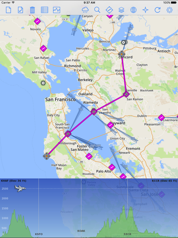
QuickPlan for iPad is a visual touch enabled flight planner that makes it easy to generate flight plans in native FSX, FS2004 or X-Plane formats. It makes a great companion for our moving map apps for iPad - iGMapHD and FSWidgets EFB.
The entire route is generated visually, by tapping the map to add the departure airport, intermediate waypoints and arrival airport in the same order that you intend flying the plan.
During plan creation and after adding the final arrival waypoint you also have the opportunity to remove any of the intermediate waypoints before saving the plan in your preferred format.
Flight plans are saved to the apps Documents folder and can be exported using the iTunes File Sharing feature. For a more convenient file export solution you can use the built-in Dropbox support to easily transfer flight plans to your Mac or PC.
QuickPlan utilizes a new mapping engine and includes 12 world-wide map styles and has support for FSWidgets Cloud Based Aero Charts (free Cuba/Puerto Rico WAC Cloud Based Chart included) and FSWidgets Cloud Based World Nav Data (Free KSFO - San Francisco Bay area Nav Data included).
QuickPlan can be used in Freeform Mode, Advanced Mode, or a combination of both.
FREEFORM MODE:
Simply tap anywhere on the map and QuickPlan will allow you to add it as a generic waypoint. VFR pilots often use towns, lakes and other unique geographic features and with QuickPlan you can add any geographical location shown on the base map. Plans created this way label the waypoints automatically with generic names (e.g. DEP, WP1, WP2, ARR).
If desired, the entire route from departure to arrival can be created without reference to any navigational aids or official airports. This is handy for bush pilots who often use unlicensed airfields and small landing strips (or seaplane landing areas). Helicopter pilots can also quickly create plans that depart from off-airport locations like building rooftops or land on a road.
ADVANCED MODE:
If you own the FSWidgets Cloud Based World Nav Data product you can create more advanced flight plans by tapping on any of the icons displayed on the map to add them as waypoints - airports, VOR's, NDB's and intersections (data for the KSFO area is included free). Plans created this way label the waypoints automatically with airport and navigational aid identifiers taken from the Nav Data (e.g. KSFO, OSI, LV, FABLA).
FEATURE LIST:
- Generates native FSX (.pln), FS2004 (.pln) and X-Plane (.fms) format flight plans
- Saves flight plans to the Documents folder, can be exported/imported
- Flight plans can be exported via iTunes File Sharing feature
- Includes optional Dropbox support for easy transfer of flight plans to Mac or PC
- Dropbox feature syncs to the folder "Dropbox/Apps/FSWidgets - QuickPlan" on your Mac or PC
- Search for airport by ICAO identifier
- Map powered by Leaflet API (using OpenStreetMap & custom data)
- Includes many world-wide maps styles
- Supports FSWidgets Cloud Based Aero Charts
- Free Cuba/Puerto Rico WAC Cloud Based Chart included
- Supports FSWidgets Cloud Based Nav Data
- Free KSFO (San Francisco Bay) area Nav Data included
- World-wide Metar and TAF Data icons
- US Nexrad (Next-Gen Radar) Data
REQUIREMENTS:
- iPad with iOS 11.0 or later.
- Flight Simulator X, Flight Simulator 2004 or X-Plane.
- Free (or Pro) Dropbox account (if using that feature)
- Dropbox must be installed on Mac or Windows PC
- Wi-Fi network required
- Internet access required, to download map data
※iPadでご利用できるアプリです。
カテゴリー
ナビゲーション
ナビゲーション
リリース
2012/6/19
2012/6/19
更新
2019/11/12
2019/11/12
バージョン
3.5
3.5
言語
英語
英語
サイズ
6 MB
6 MB
条件
iPad 互換 iOS 3.2 以降が必要
iPad 互換 iOS 3.2 以降が必要
このバージョンの新機能
- Major update for iOS 13
- New faster, smoother map rendering engine
- Fixes map zoom and pan on iOS 13
- Adds support for new iOS 13 Dark Mode
- Major update for iOS 13
- New faster, smoother map rendering engine
- Fixes map zoom and pan on iOS 13
- Adds support for new iOS 13 Dark Mode
スクリーンショット
Fermin Fernandez の他のアプリ » もっと見る
» 目的別iPhoneアプリ検索
- 辞書 » 日本語対応の辞書 » 英和辞典
- 学習 » 英単語 » 英会話 » クイズで楽しく
- スケジュール » 管理 » Googleカレンダー


Yahoo!乗換案内
Yahoo Japan Corp.無料
Google マップ - ナビ、乗換案内
Google LLC無料
Yahoo!カーナビ
Yahoo Japan Corp.無料
乗換NAVITIME(乗換ナビタイム) - 運行情報や路線図..
NAVITIME JAPAN CO.,LTD.無料
Yahoo! MAP-ヤフーマップ
Yahoo Japan Corp.無料
乗換案内
Jorudan Co.,Ltd.無料
賃貸物件検索 SUUMO(スーモ)でお部屋探し
Recruit Co.,Ltd.無料
NAVITIME(乗換と地図の総合ナビ)
NAVITIME JAPAN CO.,LTD.無料
NAVITIMEドライブサポーター - カーナビ&渋滞情報&..
NAVITIME JAPAN CO.,LTD.無料
お部屋探しはライフルホームズ賃貸・マンション・不動産物件検索
LIFULL Co., Ltd無料


CatchApp新着アプリレビュー
 日本縦断てつどうの旅」")
様々な楽しみ方で運転士として成長していく鉄道運転士育成RPG「プラチナ・トレイン(プラトレ) 日本縦断てつどうの旅」
2016-05-17 00:00

日本語にはない英語発音のリスニングを楽しく学べる「発音どっち?英語リスニング 」
2014-12-20 12:00

指先の瞬発力が試されるカジュアルゲーム「早撃ちパニック」をリリース!
2014-12-08 15:21
新着アプリ動画
-
 ¥1500
¥1500
-
 ¥600
¥600
-
 ¥3000
¥3000