


このアプリのYoutube動画がある場合はURLを送信してください。詳細 »
APPLICATION INFO - iPhoneアプリの詳細情報
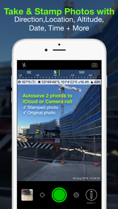
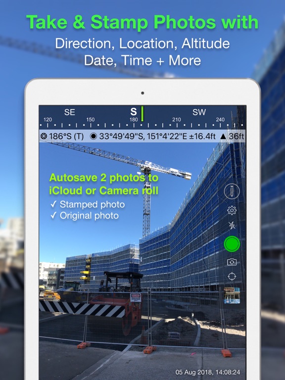
Solocator is a GPS camera for fieldwork. Overlay and stamp photos with GPS location, compass direction, altitude, date & time taken. Plus, with the Industry Pack (In-App Purchase) capture editable notes such as project name and photo description, street address and UTM/MGRS coordinate formats as well as customised exporting to Dropbox OneDrive, Google Drive including KML, KMZ and CSV files. It can auto save two photos at once - stamped photo and original high res photo with back or front facing camera. You can also view photo direction and location in map view and navigate there. So now you will always know where and when a photo was taken and how to get back there.
TAILOR THE INFO YOU NEED TO CAPTURE
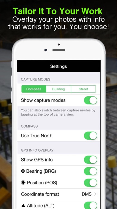
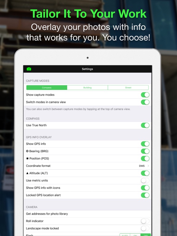
Select the information you want to overlay on your photos:
● GPS Location (Latitude & Longitude in various formats) ± Accuracy
● Compass direction – bearing
● Altitude (Metric & Imperial units)
● Local date & time based on your GPS location
● Local time zone
● UTC time
● Show compass
● Show cardinal direction in Building mode; e.g. North elevation of a building face.
● Option to use abbreviations or unicode characters for direction, position and altitude.
AUTOSAVE PHOTOS TO iCLOUD & OR CAMERA ROLL
Take and autosave two photos at once; one with stamped info and the other as an original high res photo.
WORKING WITH CAPTURED INFO
● Photos are sorted by time, location, distance from current location and by project name (if Industry Pack purchased).
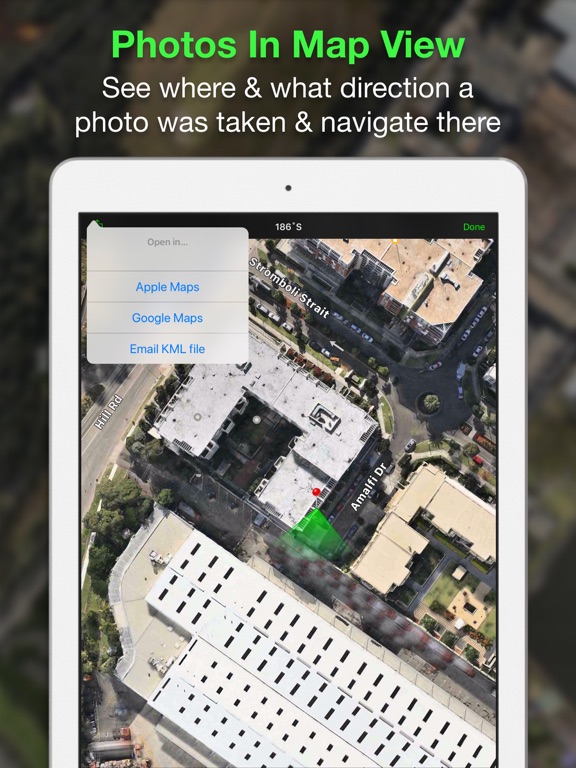
● View photo direction and location in map view and navigate there
● Share photos individually or as a zip file.
● Email photos from within the app including:
● Exif metadata
- Compass direction
- GPS position ± accuracy
- Altitude
- Date & time taken
- Street address (Industry Pack)
- Elevation of building face viewed (if selected)
- Links to maps so receiver can navigate there easily
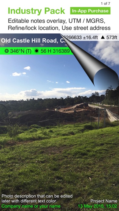
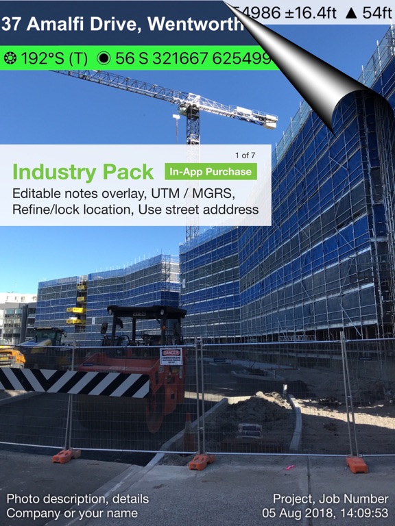
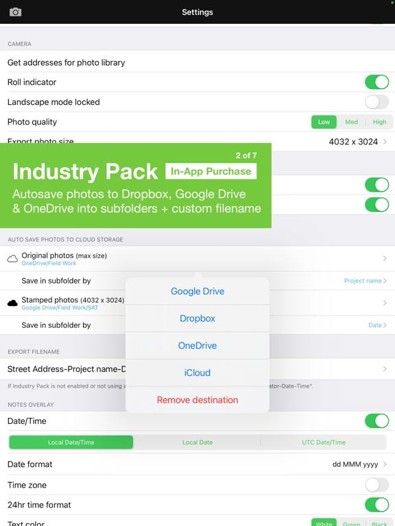
INDUSTRY PACK (In-App Purchase)
EDITABLE NOTES OVERLAY
Stamp your photos with "Project name", "Description" & “Watermark”. The Project name field could be used as job or ticket/policy number. Watermark field is typically used for company or user name. You can also go back and edit Project name, Description or Watermark fields later.
CUSTOM EXPORT FILENAME
Define your photo export filename by selecting from the following fields and what order to be used; Project Name, Description, Watermark, Street Address, Date/Time and a Custom field.
BATCH EDIT NOTES OVERLAY FIELDS
Select multiple photos from library and edit Project Name, Description & Watermark fields in one go.
STREET MODE
Selecting street mode overlays photos with street address. You can select at what distance interval to check and update street address when on the go.
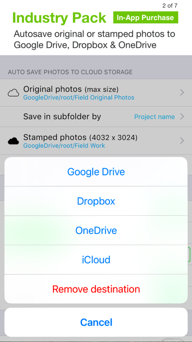
AUTOSAVE PHOTOS TO CLOUD STORAGE
Autosave original and stamped photos to Google Drive, Dropbox & OneDrive. You can also save photos in date or project name subfolders - automatically.
CUSTOM EXPORT TO DROPBOX, GOOGLE DRIVE & ONEDRIVE
Export multiple photos with captured project file names to shared team folders.
CUSTOM EXPORTING & EMAILING
Export or email multiple photos and photo info in KML, KMZ or CSV formats. Attach maps of photo locations along with your photos when exporting or emailing.
Select your combination of photos, maps and captured info in the file formats to suit your needs. Export/email photos individually or as a zip file.
TRACK PHOTOS IN MAP VIEW
View multiple photos by direction, distance between photos, area of photos taken and distance to your added markers via imported KML files or dropped pins.
REFINE AND LOCK GPS LOCATION
Ideal for those working in and around buildings; to improve your GPS location. You can also use it to lock the position of the asset or subject you’re photographing as opposed to where you’re standing.
SWITCH OFF CAPTURE MODES – GREATER FLEXIBILITY
Switch Compass, Building and Street modes off and just show GPS info bar on top of photos. Gives you more flexibility on what and how you overlay info and show more of the photo.
TAILOR THE INFO YOU NEED TO CAPTURE
Select the information you want to overlay on your photos:
● GPS Location (Latitude & Longitude in various formats) ± Accuracy
● Compass direction – bearing
● Altitude (Metric & Imperial units)
● Local date & time based on your GPS location
● Local time zone
● UTC time
● Show compass
● Show cardinal direction in Building mode; e.g. North elevation of a building face.
● Option to use abbreviations or unicode characters for direction, position and altitude.
AUTOSAVE PHOTOS TO iCLOUD & OR CAMERA ROLL
Take and autosave two photos at once; one with stamped info and the other as an original high res photo.
WORKING WITH CAPTURED INFO
● Photos are sorted by time, location, distance from current location and by project name (if Industry Pack purchased).
● View photo direction and location in map view and navigate there
● Share photos individually or as a zip file.
● Email photos from within the app including:
● Exif metadata
- Compass direction
- GPS position ± accuracy
- Altitude
- Date & time taken
- Street address (Industry Pack)
- Elevation of building face viewed (if selected)
- Links to maps so receiver can navigate there easily
INDUSTRY PACK (In-App Purchase)
EDITABLE NOTES OVERLAY
Stamp your photos with "Project name", "Description" & “Watermark”. The Project name field could be used as job or ticket/policy number. Watermark field is typically used for company or user name. You can also go back and edit Project name, Description or Watermark fields later.
CUSTOM EXPORT FILENAME
Define your photo export filename by selecting from the following fields and what order to be used; Project Name, Description, Watermark, Street Address, Date/Time and a Custom field.
BATCH EDIT NOTES OVERLAY FIELDS
Select multiple photos from library and edit Project Name, Description & Watermark fields in one go.
STREET MODE
Selecting street mode overlays photos with street address. You can select at what distance interval to check and update street address when on the go.
AUTOSAVE PHOTOS TO CLOUD STORAGE
Autosave original and stamped photos to Google Drive, Dropbox & OneDrive. You can also save photos in date or project name subfolders - automatically.
CUSTOM EXPORT TO DROPBOX, GOOGLE DRIVE & ONEDRIVE
Export multiple photos with captured project file names to shared team folders.
CUSTOM EXPORTING & EMAILING
Export or email multiple photos and photo info in KML, KMZ or CSV formats. Attach maps of photo locations along with your photos when exporting or emailing.
Select your combination of photos, maps and captured info in the file formats to suit your needs. Export/email photos individually or as a zip file.
TRACK PHOTOS IN MAP VIEW
View multiple photos by direction, distance between photos, area of photos taken and distance to your added markers via imported KML files or dropped pins.
REFINE AND LOCK GPS LOCATION
Ideal for those working in and around buildings; to improve your GPS location. You can also use it to lock the position of the asset or subject you’re photographing as opposed to where you’re standing.
SWITCH OFF CAPTURE MODES – GREATER FLEXIBILITY
Switch Compass, Building and Street modes off and just show GPS info bar on top of photos. Gives you more flexibility on what and how you overlay info and show more of the photo.
 このアプリはiPhone、iPadの両方に対応しています。
カテゴリー
ナビゲーション
ナビゲーション
リリース
2012/12/9
2012/12/9
更新
2020/12/19
2020/12/19
バージョン
2.13
2.13
言語
英語
英語
サイズ
41.5 MB
41.5 MB
条件
iPhone、iPod touch および iPad 互換 iOS 5.0 以降が必要 iPhone 5 用に最適化済み
iPhone、iPod touch および iPad 互換 iOS 5.0 以降が必要 iPhone 5 用に最適化済み
このバージョンの新機能
- Subfolders are now supported for autosaving photos to iCloud.
- Camera UI bug fix for some devices when in zoomed mode and new iPhone sizes.
New in Industry Pack
- Added support for autosaving photos to OneDrive.
- Added a user defined export filename
- Subfolders are now supported for autosaving photos to iCloud.
- Camera UI bug fix for some devices when in zoomed mode and new iPhone sizes.
New in Industry Pack
- Added support for autosaving photos to OneDrive.
- Added a user defined export filename
スクリーンショット - iPhone | iPad
スクリーンショット - iPhone | iPad
Civi Corp の他のアプリ » もっと見る
» 目的別iPhoneアプリ検索
- 辞書 » 日本語対応の辞書 » 英和辞典
- 学習 » 英単語 » 英会話 » クイズで楽しく
- スケジュール » 管理 » Googleカレンダー


Yahoo!乗換案内
Yahoo Japan Corp.無料
Google マップ - ナビ、乗換案内
Google LLC無料
Yahoo!カーナビ
Yahoo Japan Corp.無料
乗換NAVITIME(乗換ナビタイム) - 運行情報や路線図..
NAVITIME JAPAN CO.,LTD.無料
Yahoo! MAP-ヤフーマップ
Yahoo Japan Corp.無料
乗換案内
Jorudan Co.,Ltd.無料
賃貸物件検索 SUUMO(スーモ)でお部屋探し
Recruit Co.,Ltd.無料
NAVITIME(乗換と地図の総合ナビ)
NAVITIME JAPAN CO.,LTD.無料
NAVITIMEドライブサポーター - カーナビ&渋滞情報&..
NAVITIME JAPAN CO.,LTD.無料
お部屋探しはライフルホームズ賃貸・マンション・不動産物件検索
LIFULL Co., Ltd無料


CatchApp新着アプリレビュー
 日本縦断てつどうの旅」")
様々な楽しみ方で運転士として成長していく鉄道運転士育成RPG「プラチナ・トレイン(プラトレ) 日本縦断てつどうの旅」
2016-05-17 00:00

日本語にはない英語発音のリスニングを楽しく学べる「発音どっち?英語リスニング 」
2014-12-20 12:00

指先の瞬発力が試されるカジュアルゲーム「早撃ちパニック」をリリース!
2014-12-08 15:21
新着アプリ動画
-
 ¥1500
¥1500
-
 ¥600
¥600
-
 ¥3000
¥3000