


このアプリのYoutube動画がある場合はURLを送信してください。詳細 »
APPLICATION INFO - iPhoneアプリの詳細情報
FieldMove Clino Pro Features: Available as an in-app purchase
*Upgrade to Pro Features for US $4.99*
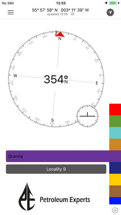
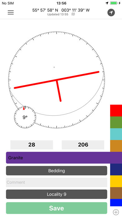
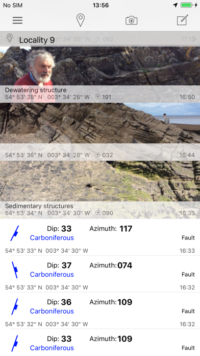
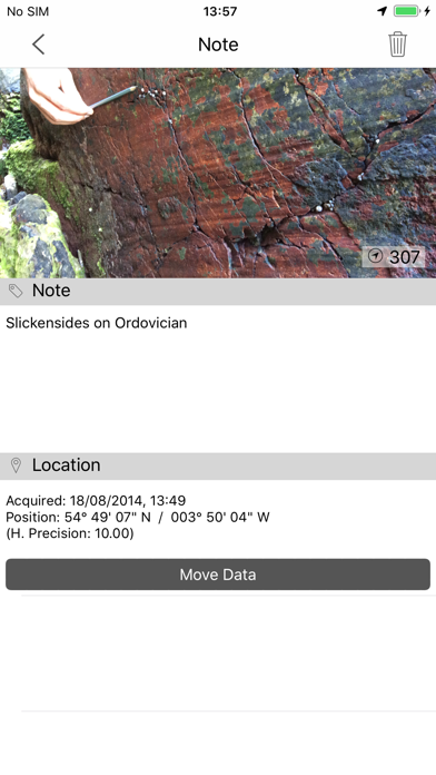
FieldMove Clino is a digital compass-clinometer for data capture on your iPhone, designed for simplicity in the field, and optimized to use the device’s GPS location and orientation sensors. This geology app will allow you to use your phone as a traditional hand-held bearing compass as well as a digital compass-clinometer for measuring and capturing the orientation of planar and linear features in the field. FieldMove Clino allows you to quickly take large amounts of measurements, making your data set much more statistically valid. You can also capture and store georeferenced digital photographs and text notes.
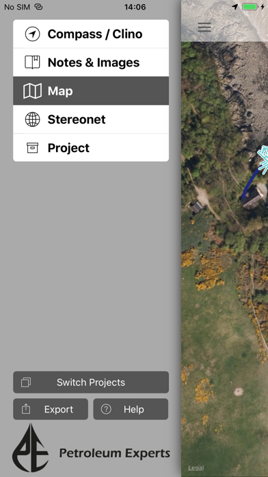
As well as supporting online maps, FieldMove Clino also supports offline maps, so that you can import your own georeferenced basemaps and collect data while disconnected. Data can be exported as MOVE, CSV or KMZ files and then imported directly into FieldMove™, Move™ or other applications like Google Earth.
Upgrade to these additional Clino Pro Features:
• Display geological data on an equal area or equal angle stereonet, allowing you to perform some basic statistical analysis in the field
• Draw contacts, faults and outcrops on your chosen basemap to create a realistic geological map
• A new expanded library of symbols for customisation of planar and linear features
• KMZ export, view your data in Google Earth
A more in-depth guide is available on our website: http://www.mve.com/digital-mapping
NOTE: FieldMove Clino for iPhone will scale up to fit on the iPad and iPad mini. Cost (as shown in the screenshots) will depend on the location of the user.
FieldMove Clino is a Midland Valley geological field mapping app designed for forward thinking geologists utilising digital data collection.
---------------------------------
* The use of GPS devices and smartphones as navigation aids. *
Global Positioning System (GPS) devices are commonly used to aid navigation, having grown in popularity over the past decade. Over the last few years, this has extended to smartphones and digital compasses, which are often equipped with GPS functionality.
GPS is a valuable aid to navigation during fieldwork, although it is important to keep safety at the forefront, and we draw your attention to the advice given by a number of mountaineering councils:
“Everyone heading into the hills needs to learn how to read a map, and be able to navigate effectively with a paper map and traditional magnetic compass, especially in poor visibility”.
Midland Valley will accept no liability or loss, resulting from the use or misuse of this product.
*Upgrade to Pro Features for US $4.99*
FieldMove Clino is a digital compass-clinometer for data capture on your iPhone, designed for simplicity in the field, and optimized to use the device’s GPS location and orientation sensors. This geology app will allow you to use your phone as a traditional hand-held bearing compass as well as a digital compass-clinometer for measuring and capturing the orientation of planar and linear features in the field. FieldMove Clino allows you to quickly take large amounts of measurements, making your data set much more statistically valid. You can also capture and store georeferenced digital photographs and text notes.
As well as supporting online maps, FieldMove Clino also supports offline maps, so that you can import your own georeferenced basemaps and collect data while disconnected. Data can be exported as MOVE, CSV or KMZ files and then imported directly into FieldMove™, Move™ or other applications like Google Earth.
Upgrade to these additional Clino Pro Features:
• Display geological data on an equal area or equal angle stereonet, allowing you to perform some basic statistical analysis in the field
• Draw contacts, faults and outcrops on your chosen basemap to create a realistic geological map
• A new expanded library of symbols for customisation of planar and linear features
• KMZ export, view your data in Google Earth
A more in-depth guide is available on our website: http://www.mve.com/digital-mapping
NOTE: FieldMove Clino for iPhone will scale up to fit on the iPad and iPad mini. Cost (as shown in the screenshots) will depend on the location of the user.
FieldMove Clino is a Midland Valley geological field mapping app designed for forward thinking geologists utilising digital data collection.
---------------------------------
* The use of GPS devices and smartphones as navigation aids. *
Global Positioning System (GPS) devices are commonly used to aid navigation, having grown in popularity over the past decade. Over the last few years, this has extended to smartphones and digital compasses, which are often equipped with GPS functionality.
GPS is a valuable aid to navigation during fieldwork, although it is important to keep safety at the forefront, and we draw your attention to the advice given by a number of mountaineering councils:
“Everyone heading into the hills needs to learn how to read a map, and be able to navigate effectively with a paper map and traditional magnetic compass, especially in poor visibility”.
Midland Valley will accept no liability or loss, resulting from the use or misuse of this product.
カテゴリー
仕事効率化
仕事効率化
リリース
2013/9/18
2013/9/18
更新
2015/12/10
2015/12/10
バージョン
2.3.3
2.3.3
言語
サイズ
24.8 MB
24.8 MB
条件
このバージョンの新機能
Minor improvements to the KMZ and CSV exports.
Minor improvements to the KMZ and CSV exports.
スクリーンショット
» 目的別iPhoneアプリ検索
- 辞書 » 日本語対応の辞書 » 英和辞典
- 学習 » 英単語 » 英会話 » クイズで楽しく
- スケジュール » 管理 » Googleカレンダー


Microsoft Excel
Microsoft Corporation無料
Microsoft Word
Microsoft Corporation無料
Microsoft PowerPoint
Microsoft Corporation無料
QRコードリーダー for iPhone
Takashi Wada無料
QRコードリーダー for iPhone - 無料で使えるQ..
無料
Gmail - Googleのメール
Google LLC無料
Lifebear カレンダーと日記とToDoを無料でスケジュ..
Lifebear inc.無料
Dropbox
Dropbox, Inc.無料
無料QRコードリーダー・バーコードリーダー-アイコニット
MEDIASEEK Inc.無料
Google ドライブ - 安全なオンライン ストレージ
Google LLC無料


CatchApp新着アプリレビュー
 日本縦断てつどうの旅」")
様々な楽しみ方で運転士として成長していく鉄道運転士育成RPG「プラチナ・トレイン(プラトレ) 日本縦断てつどうの旅」
2016-05-17 00:00

日本語にはない英語発音のリスニングを楽しく学べる「発音どっち?英語リスニング 」
2014-12-20 12:00

指先の瞬発力が試されるカジュアルゲーム「早撃ちパニック」をリリース!
2014-12-08 15:21
新着アプリ動画
-
 ¥1500
¥1500
-
 ¥600
¥600
-
 ¥3000
¥3000