


このアプリのYoutube動画がある場合はURLを送信してください。詳細 »
APPLICATION INFO - iPhoneアプリの詳細情報
Map-n-Compass is a specialized app designed for those interested in Orienteering and Amateur Radio Direction Finding navigation sports. The app is designed specifically for individuals and groups interested in learning and practicing these outdoor navigation sports. If these navigation sports are not your passion, then this app may not be for you.
PLEASE NOTE: Continued use of GPS running in the background can dramatically decrease battery life.
This app is about getting outside, designing courses, and navigation:
Map-n-Compass is designed to help beginners develop the skills needed for Orienteering and Amateur Radio Direction Finding navigation sports.
The beginner skill level lets newcomers learn without frustration. Intermediate and advanced skill levels provided progressively more challenge.
For event organizers the app provides support for designing and distributing courses and holding informal practice sessions with minimal cost and effort.
Please contact Digital Confections to provide suggestions for enhancing the app!
FEATURES
Groups with multiple iOS devices running the app can hold informal practice sessions with minimal cost and effort. The map, the compass, courses, controls, and results recording are all supported within the app. Assorted "streamed" street maps are available within the app, or custom maps can be downloaded and displayed within the app, and a small sample map is provided for illustration.
o Help is available within the app - just swipe up on any available overlay or button to access specific help.
o Universal - the app is fully functional on iPhones and iPads with GPS.
o The app works even on "deactivated" devices lacking cellular network coverage. (Streamed maps and email will not be available without network coverage.)
o GPS data is digitally filtered to enhance position accuracy.
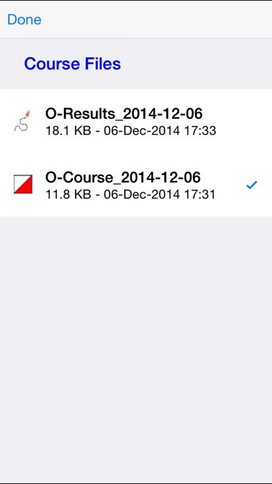
o Results files contain track, overall results and splits.
o Course and Results file sharing by email or iTunes file sharing.
o KML-format course and results files are compatible with free mapping software available from popular vendors.
o Custom map tile databases that you create and install are supported.
o Digital compass data provides directional information.
o Tiered support for beginner, intermediate and advanced skill levels.
o Multiple options for automatically rotating the map.
o Built-in timers: Time of day clock, Elapsed time, Overtime countdown with alarm.
o Text data can be overlaid atop the map: Distance, step count, GPS, and much more.
o Speed and distance unit selection, time format, lat/lon format changes are applied instantly with a single swipe.
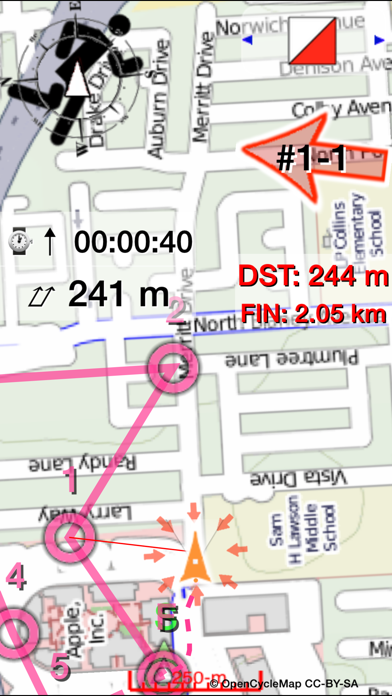
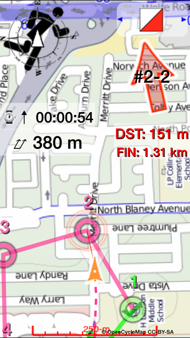
o Leg lengths and GPS locations of control points can be displayed for courses you create or download.
o Courses can be created on a PC or Mac running freely-available satellite photo software, then exported and downloaded to the app by email or iTunes file sharing.
o Courses can be created within the app and then shared by email with others using the app, or tweaked on a PC or Mac.
o Results files can be displayed and "animated" in free Earth satellite-view software to "relive" the experience - and combined with the results of others to see locations over time.
ORIENTEERING
o Beginners can see their location on the map, and receive distance and direction hints
o Intermediate level users get fewer hints.
o Advanced level users get no help from the app aside from a convenient paperless map, map rotation support and course display.
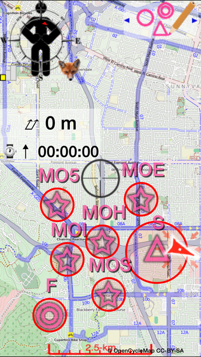
ARDF
o Bearings are recorded in "point and shoot" fashion, and are color coded to their intended target.
o From one up to five separate "foxes" can be hunted and tracked.
o Transmitter signals are simulated to provide a remarkably realistic simulated transmitter hunt experience.
o Can be used for bearing recording to live transmitters.
o The app calculates and displays the likely target locations based on bearings taken.
o Results files include bearings and target calculations.
PLEASE NOTE: Continued use of GPS running in the background can dramatically decrease battery life.
This app is about getting outside, designing courses, and navigation:
Map-n-Compass is designed to help beginners develop the skills needed for Orienteering and Amateur Radio Direction Finding navigation sports.
The beginner skill level lets newcomers learn without frustration. Intermediate and advanced skill levels provided progressively more challenge.
For event organizers the app provides support for designing and distributing courses and holding informal practice sessions with minimal cost and effort.
Please contact Digital Confections to provide suggestions for enhancing the app!
FEATURES
Groups with multiple iOS devices running the app can hold informal practice sessions with minimal cost and effort. The map, the compass, courses, controls, and results recording are all supported within the app. Assorted "streamed" street maps are available within the app, or custom maps can be downloaded and displayed within the app, and a small sample map is provided for illustration.
o Help is available within the app - just swipe up on any available overlay or button to access specific help.
o Universal - the app is fully functional on iPhones and iPads with GPS.
o The app works even on "deactivated" devices lacking cellular network coverage. (Streamed maps and email will not be available without network coverage.)
o GPS data is digitally filtered to enhance position accuracy.
o Results files contain track, overall results and splits.
o Course and Results file sharing by email or iTunes file sharing.
o KML-format course and results files are compatible with free mapping software available from popular vendors.
o Custom map tile databases that you create and install are supported.
o Digital compass data provides directional information.
o Tiered support for beginner, intermediate and advanced skill levels.
o Multiple options for automatically rotating the map.
o Built-in timers: Time of day clock, Elapsed time, Overtime countdown with alarm.
o Text data can be overlaid atop the map: Distance, step count, GPS, and much more.
o Speed and distance unit selection, time format, lat/lon format changes are applied instantly with a single swipe.
o Leg lengths and GPS locations of control points can be displayed for courses you create or download.
o Courses can be created on a PC or Mac running freely-available satellite photo software, then exported and downloaded to the app by email or iTunes file sharing.
o Courses can be created within the app and then shared by email with others using the app, or tweaked on a PC or Mac.
o Results files can be displayed and "animated" in free Earth satellite-view software to "relive" the experience - and combined with the results of others to see locations over time.
ORIENTEERING
o Beginners can see their location on the map, and receive distance and direction hints
o Intermediate level users get fewer hints.
o Advanced level users get no help from the app aside from a convenient paperless map, map rotation support and course display.
ARDF
o Bearings are recorded in "point and shoot" fashion, and are color coded to their intended target.
o From one up to five separate "foxes" can be hunted and tracked.
o Transmitter signals are simulated to provide a remarkably realistic simulated transmitter hunt experience.
o Can be used for bearing recording to live transmitters.
o The app calculates and displays the likely target locations based on bearings taken.
o Results files include bearings and target calculations.
 このアプリはiPhone、iPadの両方に対応しています。
カテゴリー
教育
教育
リリース
2013/9/13
2013/9/13
更新
2016/2/16
2016/2/16
バージョン
3.1
3.1
言語
サイズ
108 MB
108 MB
条件
このバージョンの新機能
o Adds more voice prompts and hints
o Shows position more often under poor GPS signal conditions
o Fix for crash when removing map overlays, and other stability improvements
o Adds more voice prompts and hints
o Shows position more often under poor GPS signal conditions
o Fix for crash when removing map overlays, and other stability improvements
スクリーンショット - iPhone | iPad
スクリーンショット - iPhone | iPad
Digital Confections LLC の他のアプリ » もっと見る
» 目的別iPhoneアプリ検索
- 辞書 » 日本語対応の辞書 » 英和辞典
- 学習 » 英単語 » 英会話 » クイズで楽しく
- スケジュール » 管理 » Googleカレンダー


めちゃギントン めちゃイケメンバーと擬音で遊ぼう
FujiTV無料
本気で英会話!ペラペラ英語 英単語・リスニング・TOEICの..
SpeakBUDDY Ltd.800 円
「おやこでリズムえほんDX」 赤ちゃん・幼児・子ども向けの音..
SMARTEDUCATION, Ltd.無料
星座表
ESCAPE VELOCITY LIMITED無料
続く英語学習 えいぽんたん! 英単語からリスニングまで
Drecom Co., Ltd.無料
絶対話せる!英会話
Yuko Kubota無料
英単語アプリ mikan
mikan Co.,Ltd.無料
毎日英語 音声で英語を学習して単語を管理できるアプリ
OKPanda KK無料
Studyplus - 勉強管理SNS
Studyplus Inc.無料
みんなの英単語
Jooying Tech Co.,Ltd.無料


CatchApp新着アプリレビュー
 日本縦断てつどうの旅」")
様々な楽しみ方で運転士として成長していく鉄道運転士育成RPG「プラチナ・トレイン(プラトレ) 日本縦断てつどうの旅」
2016-05-17 00:00

日本語にはない英語発音のリスニングを楽しく学べる「発音どっち?英語リスニング 」
2014-12-20 12:00

指先の瞬発力が試されるカジュアルゲーム「早撃ちパニック」をリリース!
2014-12-08 15:21
新着アプリ動画
-
 ¥1500
¥1500
-
 ¥600
¥600
-
 ¥3000
¥3000