


このアプリのYoutube動画がある場合はURLを送信してください。詳細 »
APPLICATION INFO - iPhoneアプリの詳細情報
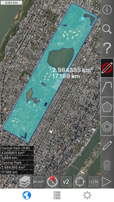
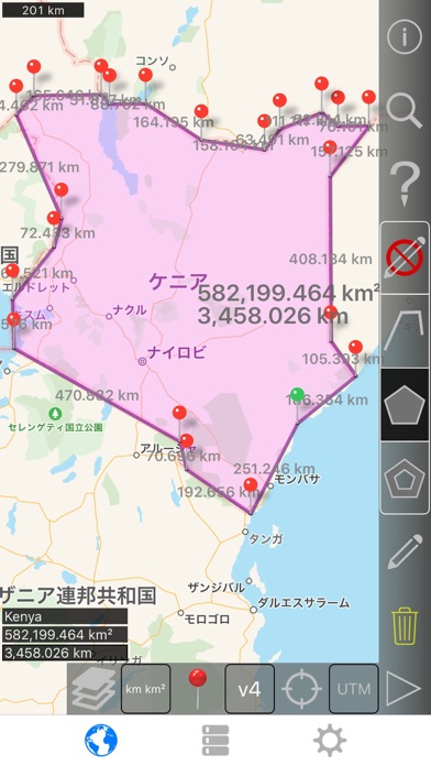
衛星から土地、道路、公園、国、湖などを測定します。 距離、エリア、および周長を計算します。
このアプリケーションは、多くの競合他社がしないことを提供する機能:
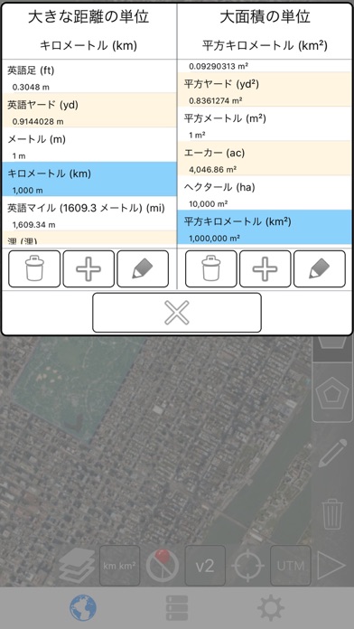
- カスタムの距離と面積の単位を追加します。
- 内部多角形を描画します。 たとえば、土地面積を削除水の体を持つ。
- パスの中間にポイントを追加 (のみのパスの末尾に追加することができます)、パスの末尾に追加するをタップ。 長いパスの中間に追加するキーを押します。
- パスまたはポリゴンの 2 つのポイントをスワップします。
- GPS 受信機から、現在の場所を追加します。
機能:
- 3 のマップ レイヤー オプション
- 輸出し、輸入の Dropbox、iCloud、電子メールなどを介して .kml ファイル
- ピンはドラッグ可能で手動で編集可能です
- 名前、ノート、および色の各パスとポリゴンのフィールド
- 電子メールやテキスト メッセージのパスとポリゴン データ
- 4 つの冗長モード。 見たい情報だけを参照してください。
- 郵便番号、市、住所などで検索します。
- 取得アドレス マップ上の近点
4 描画モード:
- パス
- ポリゴン
- 中空スペース内部でポリゴン
- (誤って編集しないように)-編集モード
パスに表示される値:
- 総距離
- 各ウェイ ポイント増分距離
多角形の表示される値:
- 地域
- 境界
- 各側面のための距離
パスまたは 4 つの方法の 1 のポリゴンにポイントを追加します。
- 地図上をタップします。
- ● 現在の場所を使用します。
- 座標を手動で入力します。
- インポート .kml ファイル
既定の距離単位を含めます。
- メートル
- フィート
- ヤード
- キロ
- マイル
- 海里
デフォルトの面積単位を含めます。
- 平方メートル
- 平方フィート
- 平方ヤード
- 平方キロメートル
- 平方マイル
- 正方形の海里
- 正方形のエーカー
- 平方ヘクタール
座標の形式。
- 度
- 度、分
- 度、分、秒表示
- UTM / UPS (ユニバーサル横メルカトル) / (ユニバーサル極ステレオグラフィック)
- MGRS (ミリタリーグリッドリファレンスシステム)
English:
Measure land, roads, parks, countries, lakes, etc from a satellite view. Calculates distances, areas, and perimeters.
Features that this application offers that most competitors do not:
- Add custom distance and area units.
- Draw interior polygons. For example, land area with bodies of water removed.
- Add a point to the middle of a path (Most only allow you to add to the end of the path) Tap to add to the end of a path. Long press to add to the middle of a path.
- Swap two points in a path or polygon.
- Add your current location from GPS receiver.
Features:
- 3 map layer options
- Export and import .kml files via Dropbox, iCloud, email, etc
- Pins are draggable and manually editable
- Name, notes, and color fields for each path and polygon
- Email or text message path and polygon data
- 4 verbosity modes. See only the information that you want to see
- Search by postal code, city, address, etc
- Get addresses near point on map
4 drawing modes:
- Path
- Polygon
- Polygon with hollow spaces inside
- No edit mode (to prevent accidental edits)
Values displayed for paths:
- Total distance
- Incremental distance for each waypoint
Values displayed for polygons:
- Area
- Perimeter
- Distance for each side
Add points to a path or polygon in 1 of 4 ways:
- Tap on the map
- Use current location
- Enter coordinates manually
- Import .kml file
Default distance units include:
- Meter
- Foot
- Yard
- Kilometer
- Mile
- Nautical mile
Default area units include:
- Square meter
- Square foot
- Square yard
- Square kilometer
- Square mile
- Square nautical mile
- Square acre
- Square hectare
Coordinate formats:
- Degrees
- Degrees, minutes
- Degrees, minutes, seconds
- UTM / UPS (Universal Transverse Mercator) / (Universal Polar Stereographic)
- MGRS (Military Grid Reference System)
このアプリケーションは、多くの競合他社がしないことを提供する機能:
- カスタムの距離と面積の単位を追加します。
- 内部多角形を描画します。 たとえば、土地面積を削除水の体を持つ。
- パスの中間にポイントを追加 (のみのパスの末尾に追加することができます)、パスの末尾に追加するをタップ。 長いパスの中間に追加するキーを押します。
- パスまたはポリゴンの 2 つのポイントをスワップします。
- GPS 受信機から、現在の場所を追加します。
機能:
- 3 のマップ レイヤー オプション
- 輸出し、輸入の Dropbox、iCloud、電子メールなどを介して .kml ファイル
- ピンはドラッグ可能で手動で編集可能です
- 名前、ノート、および色の各パスとポリゴンのフィールド
- 電子メールやテキスト メッセージのパスとポリゴン データ
- 4 つの冗長モード。 見たい情報だけを参照してください。
- 郵便番号、市、住所などで検索します。
- 取得アドレス マップ上の近点
4 描画モード:
- パス
- ポリゴン
- 中空スペース内部でポリゴン
- (誤って編集しないように)-編集モード
パスに表示される値:
- 総距離
- 各ウェイ ポイント増分距離
多角形の表示される値:
- 地域
- 境界
- 各側面のための距離
パスまたは 4 つの方法の 1 のポリゴンにポイントを追加します。
- 地図上をタップします。
- ● 現在の場所を使用します。
- 座標を手動で入力します。
- インポート .kml ファイル
既定の距離単位を含めます。
- メートル
- フィート
- ヤード
- キロ
- マイル
- 海里
デフォルトの面積単位を含めます。
- 平方メートル
- 平方フィート
- 平方ヤード
- 平方キロメートル
- 平方マイル
- 正方形の海里
- 正方形のエーカー
- 平方ヘクタール
座標の形式。
- 度
- 度、分
- 度、分、秒表示
- UTM / UPS (ユニバーサル横メルカトル) / (ユニバーサル極ステレオグラフィック)
- MGRS (ミリタリーグリッドリファレンスシステム)
English:
Measure land, roads, parks, countries, lakes, etc from a satellite view. Calculates distances, areas, and perimeters.
Features that this application offers that most competitors do not:
- Add custom distance and area units.
- Draw interior polygons. For example, land area with bodies of water removed.
- Add a point to the middle of a path (Most only allow you to add to the end of the path) Tap to add to the end of a path. Long press to add to the middle of a path.
- Swap two points in a path or polygon.
- Add your current location from GPS receiver.
Features:
- 3 map layer options
- Export and import .kml files via Dropbox, iCloud, email, etc
- Pins are draggable and manually editable
- Name, notes, and color fields for each path and polygon
- Email or text message path and polygon data
- 4 verbosity modes. See only the information that you want to see
- Search by postal code, city, address, etc
- Get addresses near point on map
4 drawing modes:
- Path
- Polygon
- Polygon with hollow spaces inside
- No edit mode (to prevent accidental edits)
Values displayed for paths:
- Total distance
- Incremental distance for each waypoint
Values displayed for polygons:
- Area
- Perimeter
- Distance for each side
Add points to a path or polygon in 1 of 4 ways:
- Tap on the map
- Use current location
- Enter coordinates manually
- Import .kml file
Default distance units include:
- Meter
- Foot
- Yard
- Kilometer
- Mile
- Nautical mile
Default area units include:
- Square meter
- Square foot
- Square yard
- Square kilometer
- Square mile
- Square nautical mile
- Square acre
- Square hectare
Coordinate formats:
- Degrees
- Degrees, minutes
- Degrees, minutes, seconds
- UTM / UPS (Universal Transverse Mercator) / (Universal Polar Stereographic)
- MGRS (Military Grid Reference System)
 このアプリはiPhone、iPadの両方に対応しています。
カテゴリー
仕事効率化
仕事効率化
リリース
2015/8/4
2015/8/4
更新
2020/9/10
2020/9/10
バージョン
2.5
2.5
言語
サイズ
8.2 MB
8.2 MB
条件
このバージョンの新機能
- ダークテーマと新しいデバイスのより良いサポート。
- マイナーなインターフェイスとレイアウトの変更。
- 最近追加された UTM および MGRS 座標形式のバグ修正。
English:
- Better support for dark theme and new devices.
- Minor interface and layout changes.
- Bug fixes for the recently added UTM and MGRS coordinate formats.
Pl
- ダークテーマと新しいデバイスのより良いサポート。
- マイナーなインターフェイスとレイアウトの変更。
- 最近追加された UTM および MGRS 座標形式のバグ修正。
English:
- Better support for dark theme and new devices.
- Minor interface and layout changes.
- Bug fixes for the recently added UTM and MGRS coordinate formats.
Pl
スクリーンショット
TappiApps の他のアプリ » もっと見る
» 目的別iPhoneアプリ検索
- 辞書 » 日本語対応の辞書 » 英和辞典
- 学習 » 英単語 » 英会話 » クイズで楽しく
- スケジュール » 管理 » Googleカレンダー


Microsoft Excel
Microsoft Corporation無料
Microsoft Word
Microsoft Corporation無料
Microsoft PowerPoint
Microsoft Corporation無料
QRコードリーダー for iPhone
Takashi Wada無料
QRコードリーダー for iPhone - 無料で使えるQ..
無料
Gmail - Googleのメール
Google LLC無料
Lifebear カレンダーと日記とToDoを無料でスケジュ..
Lifebear inc.無料
Dropbox
Dropbox, Inc.無料
無料QRコードリーダー・バーコードリーダー-アイコニット
MEDIASEEK Inc.無料
Google ドライブ - 安全なオンライン ストレージ
Google LLC無料


CatchApp新着アプリレビュー
 日本縦断てつどうの旅」")
様々な楽しみ方で運転士として成長していく鉄道運転士育成RPG「プラチナ・トレイン(プラトレ) 日本縦断てつどうの旅」
2016-05-17 00:00

日本語にはない英語発音のリスニングを楽しく学べる「発音どっち?英語リスニング 」
2014-12-20 12:00

指先の瞬発力が試されるカジュアルゲーム「早撃ちパニック」をリリース!
2014-12-08 15:21
新着アプリ動画
-
 ¥1500
¥1500
-
 ¥600
¥600
-
 ¥3000
¥3000