


このアプリのYoutube動画がある場合はURLを送信してください。詳細 »
APPLICATION INFO - iPhoneアプリの詳細情報
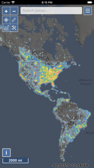
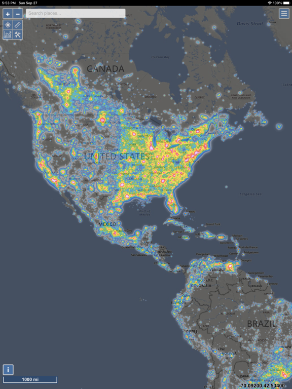
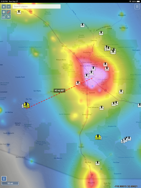
The map displays VIIRS/World Atlas/Clouds/Aurora/IAU observatories and the user SQM measurements overlay over Microsoft Bing base layers (road and hybrid Bing maps).
The primary use is to show VIIRS/DMSP data in a friendly manner, but over time it also included some other interesting overlays that concern light pollution like SQM/SQC, World Atlas 2015 zenith brightness, clouds, aurora and IAU observatories. If you have a permanent SQM reader installed you can add it to the map by sending me an e-mail.
If you want an analysis of radiance (VIIRS/DMSP) changes over a period of time, then please use the Lighttrends application (look under Help).
Please send comments and requests for new features via email (look under help)
Functionalities:
- VIIRS, Sky Brightness (World Atlas 2015), Cloud coverage and Aurora forecast layers
- VIIRS and Sky Brightness layers can be displayed in color blind friendly colors
- Road & Satellite base maps
- Cloud animation for the last 12 hours
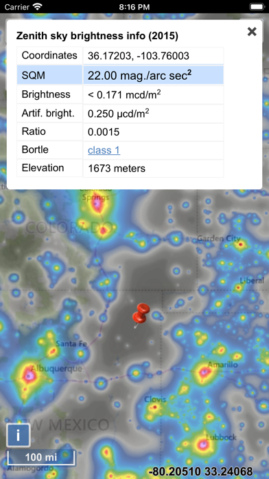
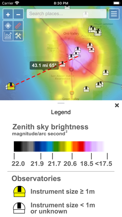
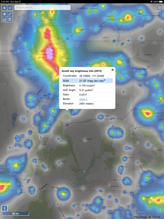
- Get detail radiance and SQM values from layers at a click. For World Atlas 2015, you also get Bortle class estimation.
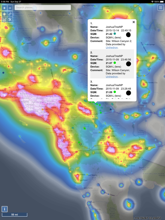
- SQM, SQM-L, SQC, SQM-LE, SQM readings submitted by users
- Submit your own SQM (L) readings
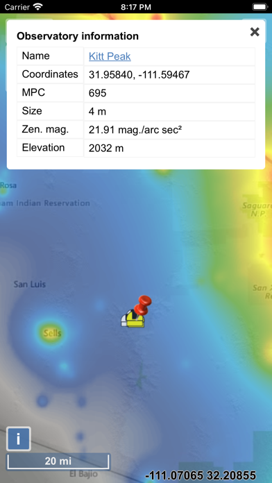
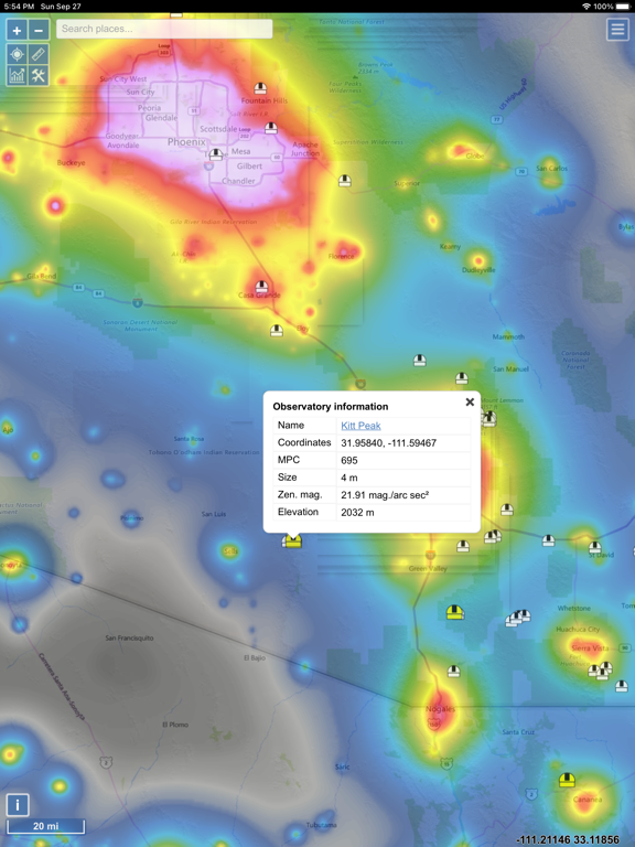
- Observatories layer
- Save your favorite locations
- Distance measurement tool with azimuth angle report
- Offline mode (Sky brightness map and a base map are saved to your device, so it will be displayed when you are offline)
The primary use is to show VIIRS/DMSP data in a friendly manner, but over time it also included some other interesting overlays that concern light pollution like SQM/SQC, World Atlas 2015 zenith brightness, clouds, aurora and IAU observatories. If you have a permanent SQM reader installed you can add it to the map by sending me an e-mail.
If you want an analysis of radiance (VIIRS/DMSP) changes over a period of time, then please use the Lighttrends application (look under Help).
Please send comments and requests for new features via email (look under help)
Functionalities:
- VIIRS, Sky Brightness (World Atlas 2015), Cloud coverage and Aurora forecast layers
- VIIRS and Sky Brightness layers can be displayed in color blind friendly colors
- Road & Satellite base maps
- Cloud animation for the last 12 hours
- Get detail radiance and SQM values from layers at a click. For World Atlas 2015, you also get Bortle class estimation.
- SQM, SQM-L, SQC, SQM-LE, SQM readings submitted by users
- Submit your own SQM (L) readings
- Observatories layer
- Save your favorite locations
- Distance measurement tool with azimuth angle report
- Offline mode (Sky brightness map and a base map are saved to your device, so it will be displayed when you are offline)
 このアプリはiPhone、iPadの両方に対応しています。
カテゴリー
ナビゲーション
ナビゲーション
リリース
2020/9/21
2020/9/21
更新
2023/8/18
2023/8/18
バージョン
1.1.21
1.1.21
言語
サイズ
25.2 MB
25.2 MB
条件
このバージョンの新機能
- VIIRS chart now has an option to display monthly values
- Fixed trailing artefact produced by the popup window on some devices
- Fixed the issue of previously downloaded offline maps not showing after app update
- Fixed the issue of search bar not showi
- VIIRS chart now has an option to display monthly values
- Fixed trailing artefact produced by the popup window on some devices
- Fixed the issue of previously downloaded offline maps not showing after app update
- Fixed the issue of search bar not showi
スクリーンショット - iPhone | iPad
スクリーンショット - iPhone | iPad
» 目的別iPhoneアプリ検索
- 辞書 » 日本語対応の辞書 » 英和辞典
- 学習 » 英単語 » 英会話 » クイズで楽しく
- スケジュール » 管理 » Googleカレンダー


Yahoo!乗換案内
Yahoo Japan Corp.無料
Google マップ - ナビ、乗換案内
Google LLC無料
Yahoo!カーナビ
Yahoo Japan Corp.無料
乗換NAVITIME(乗換ナビタイム) - 運行情報や路線図..
NAVITIME JAPAN CO.,LTD.無料
Yahoo! MAP-ヤフーマップ
Yahoo Japan Corp.無料
乗換案内
Jorudan Co.,Ltd.無料
賃貸物件検索 SUUMO(スーモ)でお部屋探し
Recruit Co.,Ltd.無料
NAVITIME(乗換と地図の総合ナビ)
NAVITIME JAPAN CO.,LTD.無料
NAVITIMEドライブサポーター - カーナビ&渋滞情報&..
NAVITIME JAPAN CO.,LTD.無料
お部屋探しはライフルホームズ賃貸・マンション・不動産物件検索
LIFULL Co., Ltd無料


CatchApp新着アプリレビュー
 日本縦断てつどうの旅」")
様々な楽しみ方で運転士として成長していく鉄道運転士育成RPG「プラチナ・トレイン(プラトレ) 日本縦断てつどうの旅」
2016-05-17 00:00

日本語にはない英語発音のリスニングを楽しく学べる「発音どっち?英語リスニング 」
2014-12-20 12:00

指先の瞬発力が試されるカジュアルゲーム「早撃ちパニック」をリリース!
2014-12-08 15:21
新着アプリ動画
-
 ¥1500
¥1500
-
 ¥600
¥600
-
 ¥3000
¥3000