


このアプリのYoutube動画がある場合はURLを送信してください。詳細 »
APPLICATION INFO - iPhoneアプリの詳細情報
The premium and best app for Nautical Navigation Charts and Maps:
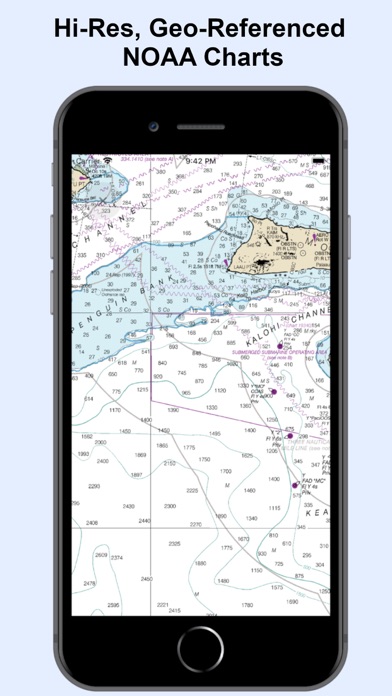
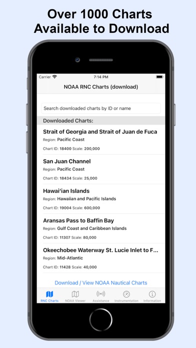
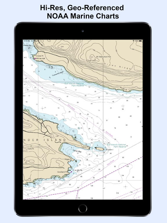
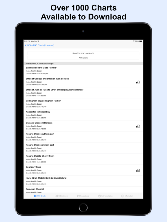
* 1000+ NOAA Raster Navigational Charts (RNC) available for download and for offline use. RNC are high resolution, full-color, geo-referenced, digital images of NOAA paper nautical charts.
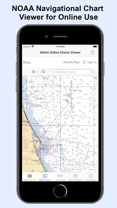
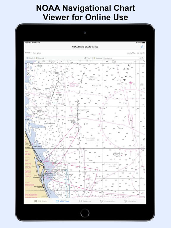
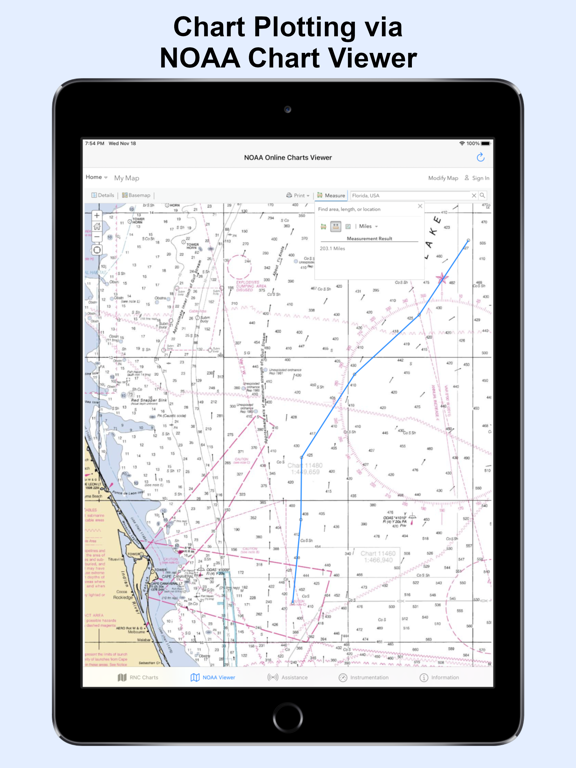
* 1000+ NOAA Navigational Charts for online use that includes GPS location, navigation plotting and more.
* Basic instrumentation - GPS location, Longitude, Latitude and Device Compass.
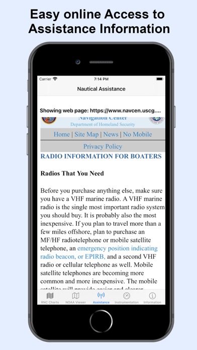
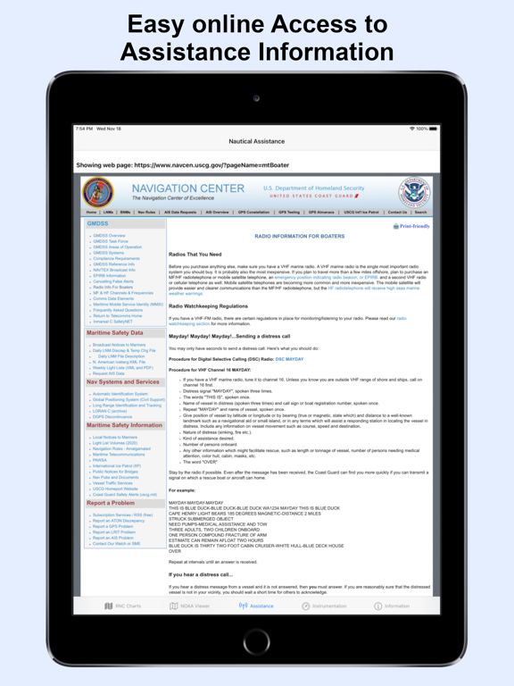
* Assitance Support - Link to Navigation Center, Radio Information.for Boaters.
Additional information about the charts and data provided with this app:
NOAA RNC® charts are full-color, geo-referenced, digital images of NOAA paper nautical charts.
RNCs can be used with global positioning system (GPS) enabled electronic chart systems or other “chart plotter” display systems to provide real-time vessel positioning.
NOAA RNCs comply with the International Hydrographic Organization RNC Product Specification.
RNCs are approved for use by IMO ECDIS mandated vessels only if adequate ENC data is not available. Since complete ENC coverage is available in all U.S. waters, vessels required to use ECDIS may not navigate with NOAA RNCs.
NOAA RNCs DO NOT meet USCG chart carriage requirements for commercial vessels.
NOAA RNCs may be downloaded free from the NOAA chart locator or the NOAA nautical chart catalog.
----------
Electronic Navigational Charts (ENC) are vector data sets that support all types of marine navigation. Originally designed for large commercial vessels using a sophisticated navigational computer called an Electronic Chart Display and Information System (ECDIS), ENCs are now also being used on simpler electronic chart systems and “chart plotters” on many types of ships and by recreational boaters. NOAA ENCs help provide real-time ship positioning, as well as collision and grounding avoidance.
NOAA ENCs comply with the International Hydrographic Organization ENC Product Specification. ENCs are produced around the world by many different countries’ national hydrographic or charting agencies. NOAA maintains more than 1,000 NOAA ENC® datasets over U.S. coastal waters and the Great Lakes. The U.S. Army Corps of Engineers produces a similar product, called Inland ENC (IENC) for many U.S. rivers.
* 1000+ NOAA Raster Navigational Charts (RNC) available for download and for offline use. RNC are high resolution, full-color, geo-referenced, digital images of NOAA paper nautical charts.
* 1000+ NOAA Navigational Charts for online use that includes GPS location, navigation plotting and more.
* Basic instrumentation - GPS location, Longitude, Latitude and Device Compass.
* Assitance Support - Link to Navigation Center, Radio Information.for Boaters.
Additional information about the charts and data provided with this app:
NOAA RNC® charts are full-color, geo-referenced, digital images of NOAA paper nautical charts.
RNCs can be used with global positioning system (GPS) enabled electronic chart systems or other “chart plotter” display systems to provide real-time vessel positioning.
NOAA RNCs comply with the International Hydrographic Organization RNC Product Specification.
RNCs are approved for use by IMO ECDIS mandated vessels only if adequate ENC data is not available. Since complete ENC coverage is available in all U.S. waters, vessels required to use ECDIS may not navigate with NOAA RNCs.
NOAA RNCs DO NOT meet USCG chart carriage requirements for commercial vessels.
NOAA RNCs may be downloaded free from the NOAA chart locator or the NOAA nautical chart catalog.
----------
Electronic Navigational Charts (ENC) are vector data sets that support all types of marine navigation. Originally designed for large commercial vessels using a sophisticated navigational computer called an Electronic Chart Display and Information System (ECDIS), ENCs are now also being used on simpler electronic chart systems and “chart plotters” on many types of ships and by recreational boaters. NOAA ENCs help provide real-time ship positioning, as well as collision and grounding avoidance.
NOAA ENCs comply with the International Hydrographic Organization ENC Product Specification. ENCs are produced around the world by many different countries’ national hydrographic or charting agencies. NOAA maintains more than 1,000 NOAA ENC® datasets over U.S. coastal waters and the Great Lakes. The U.S. Army Corps of Engineers produces a similar product, called Inland ENC (IENC) for many U.S. rivers.
 このアプリはiPhone、iPadの両方に対応しています。
カテゴリー
ナビゲーション
ナビゲーション
リリース
2020/11/17
2020/11/17
更新
2020/11/19
2020/11/19
バージョン
1.2
1.2
言語
サイズ
0.9 MB
0.9 MB
条件
このバージョンの新機能
RNC Viewer integration for online Charts
RNC Viewer integration for online Charts
スクリーンショット - iPhone | iPad
スクリーンショット - iPhone | iPad
Aleksandar Grkov の他のアプリ » もっと見る
» 目的別iPhoneアプリ検索
- 辞書 » 日本語対応の辞書 » 英和辞典
- 学習 » 英単語 » 英会話 » クイズで楽しく
- スケジュール » 管理 » Googleカレンダー


Yahoo!乗換案内
Yahoo Japan Corp.無料
Google マップ - ナビ、乗換案内
Google LLC無料
Yahoo!カーナビ
Yahoo Japan Corp.無料
乗換NAVITIME(乗換ナビタイム) - 運行情報や路線図..
NAVITIME JAPAN CO.,LTD.無料
Yahoo! MAP-ヤフーマップ
Yahoo Japan Corp.無料
乗換案内
Jorudan Co.,Ltd.無料
賃貸物件検索 SUUMO(スーモ)でお部屋探し
Recruit Co.,Ltd.無料
NAVITIME(乗換と地図の総合ナビ)
NAVITIME JAPAN CO.,LTD.無料
NAVITIMEドライブサポーター - カーナビ&渋滞情報&..
NAVITIME JAPAN CO.,LTD.無料
お部屋探しはライフルホームズ賃貸・マンション・不動産物件検索
LIFULL Co., Ltd無料


CatchApp新着アプリレビュー
 日本縦断てつどうの旅」")
様々な楽しみ方で運転士として成長していく鉄道運転士育成RPG「プラチナ・トレイン(プラトレ) 日本縦断てつどうの旅」
2016-05-17 00:00

日本語にはない英語発音のリスニングを楽しく学べる「発音どっち?英語リスニング 」
2014-12-20 12:00

指先の瞬発力が試されるカジュアルゲーム「早撃ちパニック」をリリース!
2014-12-08 15:21
新着アプリ動画
-
 ¥1500
¥1500
-
 ¥600
¥600
-
 ¥3000
¥3000