


このアプリのYoutube動画がある場合はURLを送信してください。詳細 »
APPLICATION INFO - iPhoneアプリの詳細情報
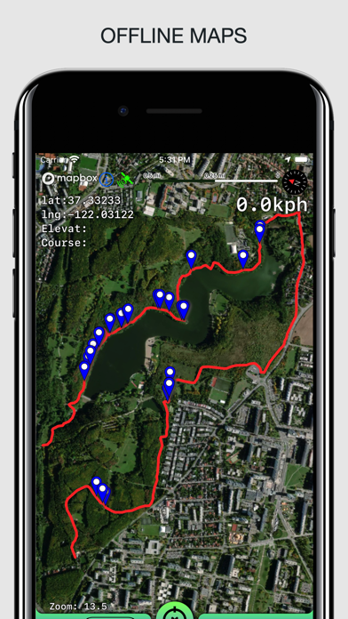
Create, import, export tracks with waypoints. Supports offline maps, no time limits, no ads, no in-app purchases.
The main functions of the application:
- loading and unlimited storage of maps of the travel area.
- built-in barometer and pedometer running in the background when the application is closed.
- supports all import and export methods available for your device with services, friends and applications in .gpx format.
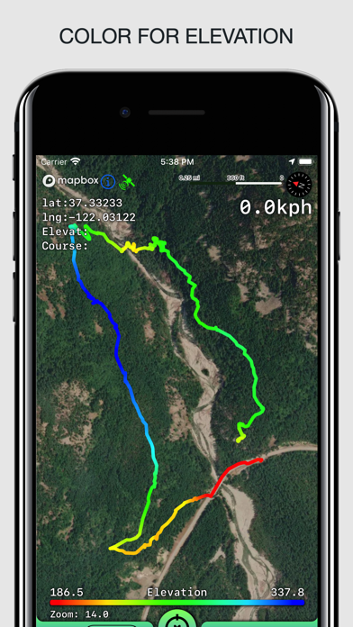
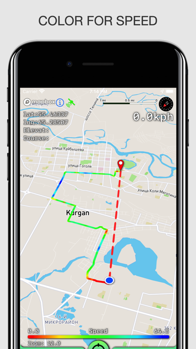
- color gradient for speed and height, if this information is in the imported track.
- color gradient for speed and height for recorded tracks.
- recording speed and altitude in the track.
- extended track information: average and maximum speed, track duration by time and distance, number of waypoints.
- relief lines in outdoor mode.
- different units of measurement: miles, kilometers, feet, meters.
- free search for places by address or place name
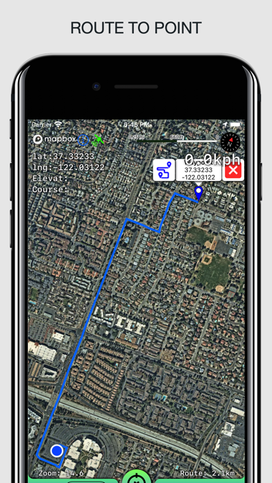
- free building routes for different driving modes (no more than 300 per month).
- storage and export of routes.
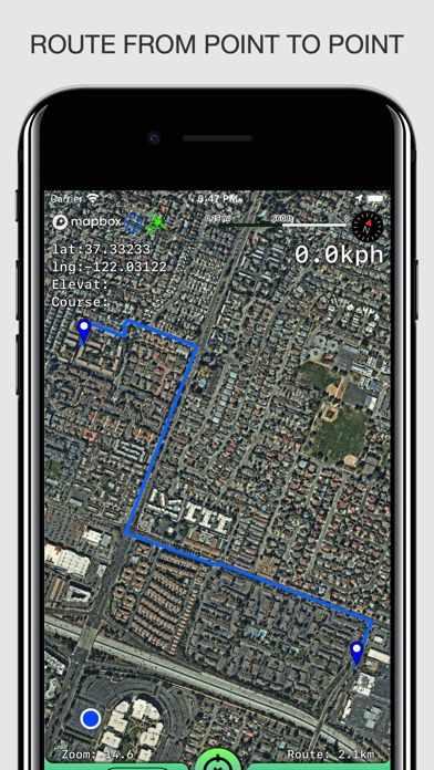
- building routes from the current position to a point or from point to point.
- the ability to record tracks in the background.
- does not contain in-app purchases, additional payments for cards, advertisements and has no time limits for use.
- viewing one or several tracks in any application mode, including the recording mode of another track.
- installation, editing, deletion of waypoints in any application mode and anywhere.
- the ability to adjust the quality of the track, distance filters, energy saving mode.
- export and import of tracks and waypoints to various services - Open Street Map and others.
- display of additional information - scale, coordinates, height, speed.
- shows the current distance traveled by the track and the travel or walk time.
- has several map styles - satellite, streets, combo and dark.
- Supports dark theme for iOS 13-14.
- easy start and stop of tracking in several ways.
- the ability to continue any previously recorded or imported track.
- several modes of map orientation - by the heading of the phone, in the direction of travel, centering and to the north.
- Possibility of tilting the map with double pinch.
- quick and easy selection and viewing of saved tracks, waypoints and maps.
- speed and altitude graphs can be scaled and scrolled.
The main functions of the application:
- loading and unlimited storage of maps of the travel area.
- built-in barometer and pedometer running in the background when the application is closed.
- supports all import and export methods available for your device with services, friends and applications in .gpx format.
- color gradient for speed and height, if this information is in the imported track.
- color gradient for speed and height for recorded tracks.
- recording speed and altitude in the track.
- extended track information: average and maximum speed, track duration by time and distance, number of waypoints.
- relief lines in outdoor mode.
- different units of measurement: miles, kilometers, feet, meters.
- free search for places by address or place name
- free building routes for different driving modes (no more than 300 per month).
- storage and export of routes.
- building routes from the current position to a point or from point to point.
- the ability to record tracks in the background.
- does not contain in-app purchases, additional payments for cards, advertisements and has no time limits for use.
- viewing one or several tracks in any application mode, including the recording mode of another track.
- installation, editing, deletion of waypoints in any application mode and anywhere.
- the ability to adjust the quality of the track, distance filters, energy saving mode.
- export and import of tracks and waypoints to various services - Open Street Map and others.
- display of additional information - scale, coordinates, height, speed.
- shows the current distance traveled by the track and the travel or walk time.
- has several map styles - satellite, streets, combo and dark.
- Supports dark theme for iOS 13-14.
- easy start and stop of tracking in several ways.
- the ability to continue any previously recorded or imported track.
- several modes of map orientation - by the heading of the phone, in the direction of travel, centering and to the north.
- Possibility of tilting the map with double pinch.
- quick and easy selection and viewing of saved tracks, waypoints and maps.
- speed and altitude graphs can be scaled and scrolled.
カテゴリー
ナビゲーション
ナビゲーション
リリース
2021/1/24
2021/1/24
更新
2024/3/31
2024/3/31
バージョン
3.3.2
3.3.2
言語
サイズ
21.3 MB
21.3 MB
条件
このバージョンの新機能
bug fixes
bug fixes
スクリーンショット
SERGEY BEZDENEZHNYKH の他のアプリ » もっと見る
» 目的別iPhoneアプリ検索
- 辞書 » 日本語対応の辞書 » 英和辞典
- 学習 » 英単語 » 英会話 » クイズで楽しく
- スケジュール » 管理 » Googleカレンダー


Yahoo!乗換案内
Yahoo Japan Corp.無料
Google マップ - ナビ、乗換案内
Google LLC無料
Yahoo!カーナビ
Yahoo Japan Corp.無料
乗換NAVITIME(乗換ナビタイム) - 運行情報や路線図..
NAVITIME JAPAN CO.,LTD.無料
Yahoo! MAP-ヤフーマップ
Yahoo Japan Corp.無料
乗換案内
Jorudan Co.,Ltd.無料
賃貸物件検索 SUUMO(スーモ)でお部屋探し
Recruit Co.,Ltd.無料
NAVITIME(乗換と地図の総合ナビ)
NAVITIME JAPAN CO.,LTD.無料
NAVITIMEドライブサポーター - カーナビ&渋滞情報&..
NAVITIME JAPAN CO.,LTD.無料
お部屋探しはライフルホームズ賃貸・マンション・不動産物件検索
LIFULL Co., Ltd無料


CatchApp新着アプリレビュー
 日本縦断てつどうの旅」")
様々な楽しみ方で運転士として成長していく鉄道運転士育成RPG「プラチナ・トレイン(プラトレ) 日本縦断てつどうの旅」
2016-05-17 00:00

日本語にはない英語発音のリスニングを楽しく学べる「発音どっち?英語リスニング 」
2014-12-20 12:00

指先の瞬発力が試されるカジュアルゲーム「早撃ちパニック」をリリース!
2014-12-08 15:21
新着アプリ動画
-
 ¥1500
¥1500
-
 ¥600
¥600
-
 ¥3000
¥3000