


このアプリのYoutube動画がある場合はURLを送信してください。詳細 »
APPLICATION INFO - iPhoneアプリの詳細情報
*Air Navigation Pro requires a subscription. Visit our website for more information.
Air Navigation Pro is a high-quality flight assistant app, with real time GPS navigation for mainly VFR pilots. You can plan and track your flights and have access to a database of worldwide airspaces and waypoints. Prepare your flight better than ever with Air Navigation Pro!
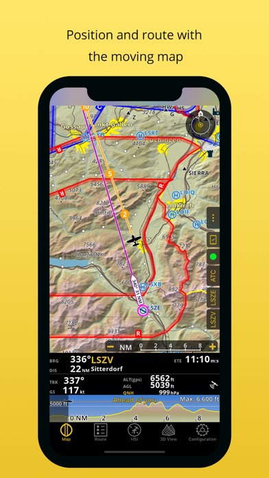
MOVING MAP AND FLIGHT PLANNING FUNCTIONS
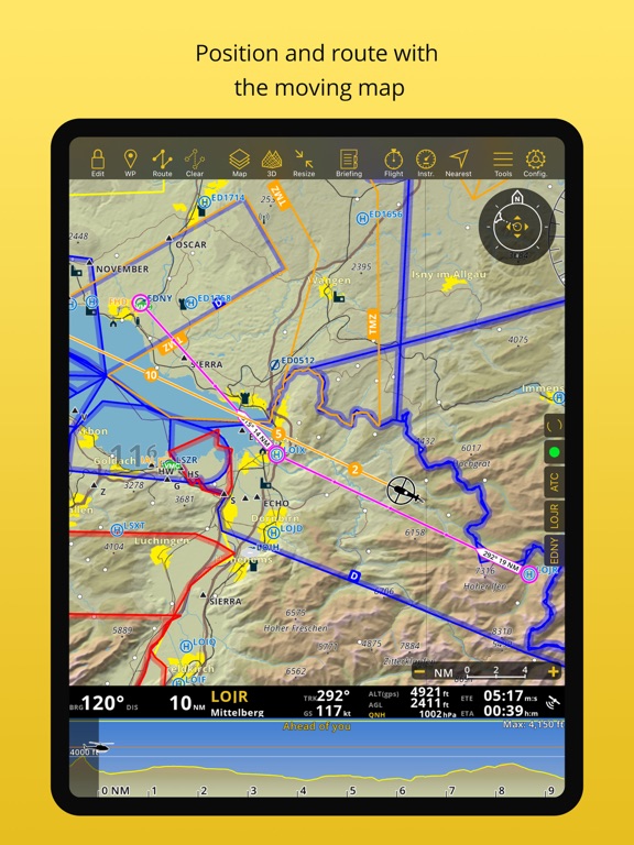
The Moving Map displays aeronautical charts as background, interactive waypoints, airspaces and planned route. Plan and edit with the Flight Planning function, directly from the moving map or by searching the waypoint’s database. The planned route will be displayed on the moving together with further information such as next point distance, track, heading and many more.
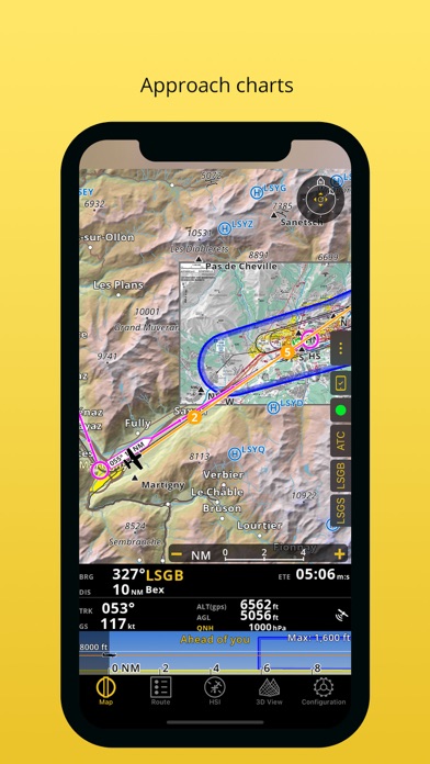
APPROACH CHARTS
The georeferenced approach charts are designed for maximum visibility. Displaying now also in the 3D view, they provide increase awareness of your surroundings during take-off and landing.
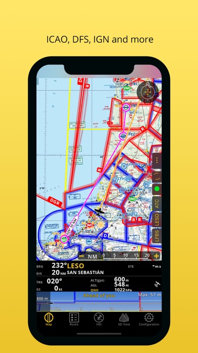
AERONAUTICAL CHARTS, PROFILE VIEW AND 3D VIEW
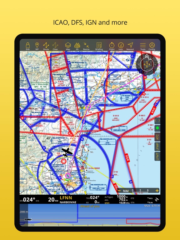
We provide a worldwide selection of free and paid charts including the main ICAO charts. The Profile View gives all terrain information for better situation awareness and safety enhancement. The 3D view provides enhanced terrain awareness and is compatible with georeferenced approach charts.
INSTRUMENTS, ALERTS, AND TRAFFIC AWARENESS
Simulate aircraft instruments, for both helicopters and airplanes, by gathering information from GPS and other sensors. Set a wide range of alerts customized to your needs, for example to notify you when a target altitude has been reached or abandoned.
Enhance safety with the Traffic Awareness feature by decreasing the risk of a collision, fly simultaneously or follow another aircraft that you marked*
*requires GSM internet connection or an external device
DATABASE AND SEARCH ENGINE
Global aeronautical database with over 200,000 waypoints and 50,000 airspaces constantly being updated. Search and navigate to specific locations. Also create, edit and export custom waypoints and routes and create aircraft profiles for both helicopters and airplanes.
AUTOMATIC LOGBOOK, FLIGHT PLAN AND BRIEFING
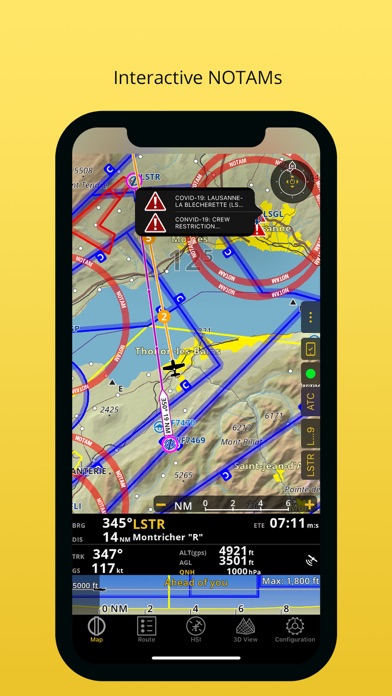
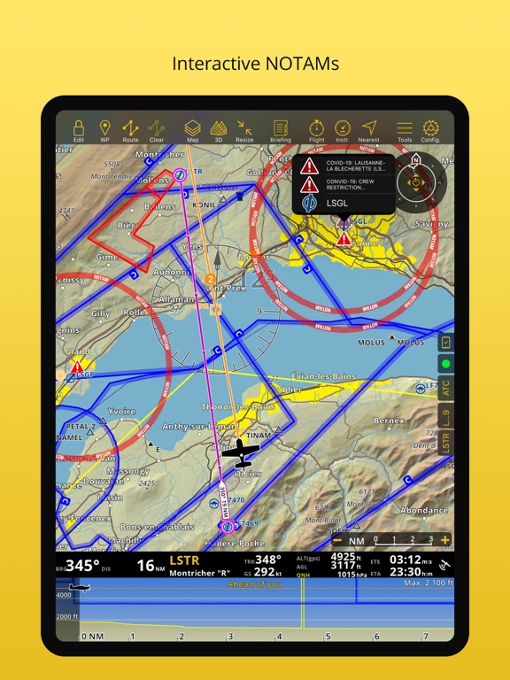
The Logbook uses GPS information, and is automatic and fully editable. It can be shared via email or via the integrated webserver. Create different files, like the Operational Flight Plan or the NOTAMs Briefing, that will help you document your flight and follow your plan as you communicate with Air Traffic Services. Interactive NOTAMs are now included in our packages. Interactive NOTAMs are updated NOTAMs tailored for your flight and shortened to avoid information overload.
LIVE TRACKING, FLIGHT RECORDING
Follow your flight in real time, record your flight, replay and analyze your trace. The recorded flight can also be exported as KML file and be viewed on Google Earth.
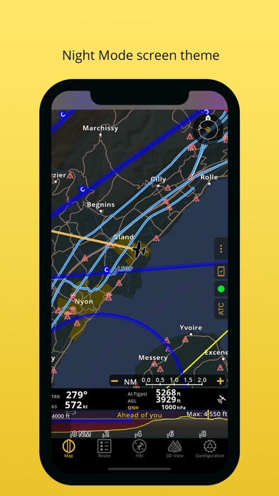
ADDITIONAL FEATURES
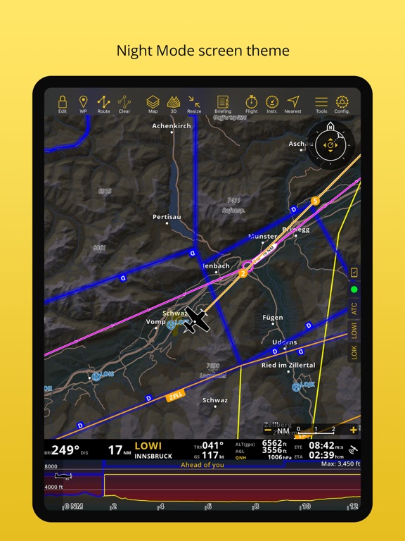
Night Vision
Sharing Functions and Live Tracking
Custom waypoint editor
Weight and Balance Computer
Supports external modules
Synchronize routes from Air Navigation Pro OS X
REQUIREMENTS
iPads “WiFi only” don’t include an internal GPS receptor, an external sensor is needed for these devices. Check out our Online User Manual at http://manual.airnavigation.aero
This app offers yearly auto-renewable subscriptions.
Please read Air Navigation Pro terms of use: https://airnavigation.aero/terms-of-use.html
*Please note that this software isn’t intended to replace a certified navigation device. You should always use official aeronautical documentation when preparing and performing a flight and always use certified navigation devices when performing a flight.
Air Navigation Pro is a high-quality flight assistant app, with real time GPS navigation for mainly VFR pilots. You can plan and track your flights and have access to a database of worldwide airspaces and waypoints. Prepare your flight better than ever with Air Navigation Pro!
MOVING MAP AND FLIGHT PLANNING FUNCTIONS
The Moving Map displays aeronautical charts as background, interactive waypoints, airspaces and planned route. Plan and edit with the Flight Planning function, directly from the moving map or by searching the waypoint’s database. The planned route will be displayed on the moving together with further information such as next point distance, track, heading and many more.
APPROACH CHARTS
The georeferenced approach charts are designed for maximum visibility. Displaying now also in the 3D view, they provide increase awareness of your surroundings during take-off and landing.
AERONAUTICAL CHARTS, PROFILE VIEW AND 3D VIEW
We provide a worldwide selection of free and paid charts including the main ICAO charts. The Profile View gives all terrain information for better situation awareness and safety enhancement. The 3D view provides enhanced terrain awareness and is compatible with georeferenced approach charts.
INSTRUMENTS, ALERTS, AND TRAFFIC AWARENESS
Simulate aircraft instruments, for both helicopters and airplanes, by gathering information from GPS and other sensors. Set a wide range of alerts customized to your needs, for example to notify you when a target altitude has been reached or abandoned.
Enhance safety with the Traffic Awareness feature by decreasing the risk of a collision, fly simultaneously or follow another aircraft that you marked*
*requires GSM internet connection or an external device
DATABASE AND SEARCH ENGINE
Global aeronautical database with over 200,000 waypoints and 50,000 airspaces constantly being updated. Search and navigate to specific locations. Also create, edit and export custom waypoints and routes and create aircraft profiles for both helicopters and airplanes.
AUTOMATIC LOGBOOK, FLIGHT PLAN AND BRIEFING
The Logbook uses GPS information, and is automatic and fully editable. It can be shared via email or via the integrated webserver. Create different files, like the Operational Flight Plan or the NOTAMs Briefing, that will help you document your flight and follow your plan as you communicate with Air Traffic Services. Interactive NOTAMs are now included in our packages. Interactive NOTAMs are updated NOTAMs tailored for your flight and shortened to avoid information overload.
LIVE TRACKING, FLIGHT RECORDING
Follow your flight in real time, record your flight, replay and analyze your trace. The recorded flight can also be exported as KML file and be viewed on Google Earth.
ADDITIONAL FEATURES
Night Vision
Sharing Functions and Live Tracking
Custom waypoint editor
Weight and Balance Computer
Supports external modules
Synchronize routes from Air Navigation Pro OS X
REQUIREMENTS
iPads “WiFi only” don’t include an internal GPS receptor, an external sensor is needed for these devices. Check out our Online User Manual at http://manual.airnavigation.aero
This app offers yearly auto-renewable subscriptions.
Please read Air Navigation Pro terms of use: https://airnavigation.aero/terms-of-use.html
*Please note that this software isn’t intended to replace a certified navigation device. You should always use official aeronautical documentation when preparing and performing a flight and always use certified navigation devices when performing a flight.
 このアプリはiPhone、iPadの両方に対応しています。
カテゴリー
ナビゲーション
ナビゲーション
リリース
2020/10/15
2020/10/15
バージョン
8.0.250
8.0.250
言語
英語
英語
サイズ
169.2 MB
169.2 MB
条件
iPhone、iPod touch および iPad 互換 iOS 5.1 以降が必要 iPhone 5 用に最適化済み
iPhone、iPod touch および iPad 互換 iOS 5.1 以降が必要 iPhone 5 用に最適化済み
このバージョンの新機能
Thanks for using Air Navigation Pro! We regularly update our app to fix bugs, improve performance and add new features to help you fly with the highest level of safety, awareness and pleasure at the same time.
Thanks for using Air Navigation Pro! We regularly update our app to fix bugs, improve performance and add new features to help you fly with the highest level of safety, awareness and pleasure at the same time.
スクリーンショット - iPhone | iPad
スクリーンショット - iPhone | iPad
» 目的別iPhoneアプリ検索
- 辞書 » 日本語対応の辞書 » 英和辞典
- 学習 » 英単語 » 英会話 » クイズで楽しく
- スケジュール » 管理 » Googleカレンダー


Yahoo!乗換案内
Yahoo Japan Corp.無料
Google マップ - ナビ、乗換案内
Google LLC無料
Yahoo!カーナビ
Yahoo Japan Corp.無料
乗換NAVITIME(乗換ナビタイム) - 運行情報や路線図..
NAVITIME JAPAN CO.,LTD.無料
Yahoo! MAP-ヤフーマップ
Yahoo Japan Corp.無料
乗換案内
Jorudan Co.,Ltd.無料
賃貸物件検索 SUUMO(スーモ)でお部屋探し
Recruit Co.,Ltd.無料
NAVITIME(乗換と地図の総合ナビ)
NAVITIME JAPAN CO.,LTD.無料
NAVITIMEドライブサポーター - カーナビ&渋滞情報&..
NAVITIME JAPAN CO.,LTD.無料
お部屋探しはライフルホームズ賃貸・マンション・不動産物件検索
LIFULL Co., Ltd無料


CatchApp新着アプリレビュー
 日本縦断てつどうの旅」")
様々な楽しみ方で運転士として成長していく鉄道運転士育成RPG「プラチナ・トレイン(プラトレ) 日本縦断てつどうの旅」
2016-05-17 00:00

日本語にはない英語発音のリスニングを楽しく学べる「発音どっち?英語リスニング 」
2014-12-20 12:00

指先の瞬発力が試されるカジュアルゲーム「早撃ちパニック」をリリース!
2014-12-08 15:21
新着アプリ動画
-
 ¥1500
¥1500
-
 ¥600
¥600
-
 ¥3000
¥3000