


このアプリのYoutube動画がある場合はURLを送信してください。詳細 »
APPLICATION INFO - iPhoneアプリの詳細情報
Did you just experience an earthquake? Find out how close and how big it was with iFeltThat, the most customizable worldwide earthquake app for the iPhone and iPod touch.
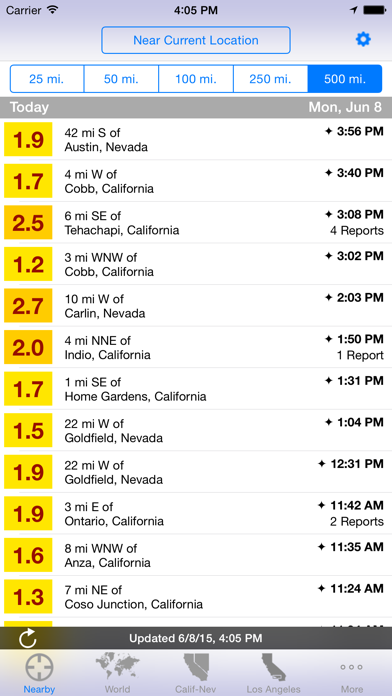
iFeltThat retrieves information directly from official USGS sources to show you seven days of microquake activity as low as magnitude 1.0 in most U.S. regions. Earthquake lists for U.S. regions show you precisely where an event occurred (not just "Northern California," but "5 mi SE of Santa Rosa, CA"). Rotate any list view to see the region-wide map. You can also see at a glance how many citizens reported the event to the USGS "Did You Feel It?" service
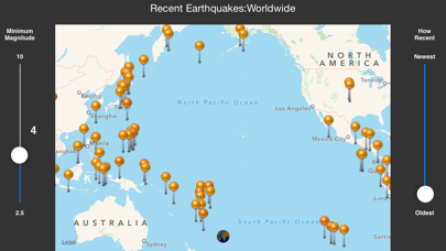
In addition to 20 region-specific event listings around the world (visit support page for a complete list), iFeltThat features a Nearby region, which uses your current location as a center point. Add an unlimited number of center points from your Address Book to keep an eye on seismic activity near your family and friends (or your own hometown while you travel) down to magnitude 1.0 in the U.S. (4.5 elsewhere). Or set a center point from any event location around the world to monitor earthquake swarms within 500 miles of the center point.
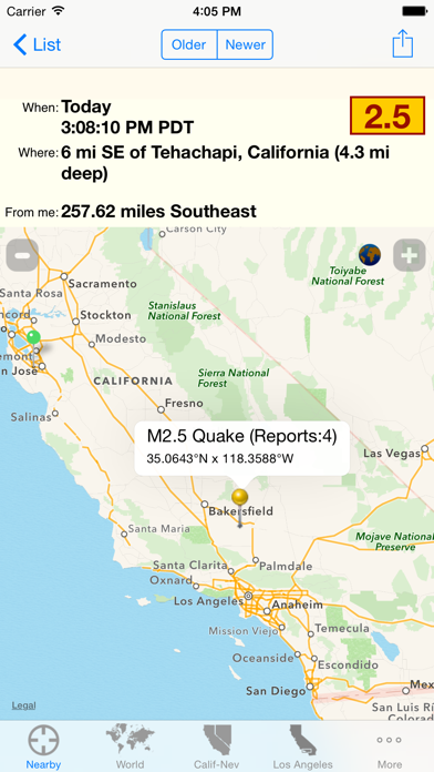
View single-event and interactive region-wide maps in roadmap or satellite hybrid styles. All maps are pinch-zoomable and draggable, just like the Maps app. Optional one-touch zoom buttons in detail maps let you zoom in and out quickly for one-handed operation while on the go. Tap the Newer and Older buttons to navigate instantly from quake detail to quake detail without having to go back to the list.
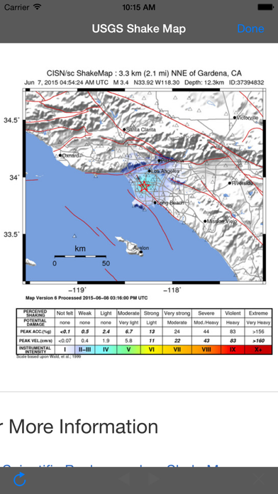
Whenever a ••USGS Shake Map•• is available for an event, a special icon appears in that event's detail view. Tap the icon to see the Shake Map within iFeltThat. In fact, all related web pages (including direct access to North American and Pacific/Indian Ocean ••Tsunami Warnings••) appear inside the app. Also from inside the app, send an email with info, links, and a screenshot of an event detail screen/map to anyone you like.
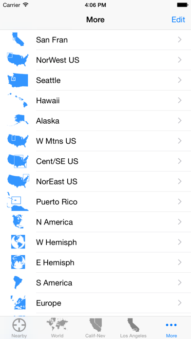
Customize which four regions are ready to view at a single tap on the bottom bar. For each region list, set the minimum magnitude threshold and default map zoom level.
One earthquake may have brought you to iFeltThat. You'll be so intrigued monitoring unexpected earth movements near you and around the world that you may find yourself using IFeltThat more often than you check the weather or news.
iFeltThat retrieves information directly from official USGS sources to show you seven days of microquake activity as low as magnitude 1.0 in most U.S. regions. Earthquake lists for U.S. regions show you precisely where an event occurred (not just "Northern California," but "5 mi SE of Santa Rosa, CA"). Rotate any list view to see the region-wide map. You can also see at a glance how many citizens reported the event to the USGS "Did You Feel It?" service
In addition to 20 region-specific event listings around the world (visit support page for a complete list), iFeltThat features a Nearby region, which uses your current location as a center point. Add an unlimited number of center points from your Address Book to keep an eye on seismic activity near your family and friends (or your own hometown while you travel) down to magnitude 1.0 in the U.S. (4.5 elsewhere). Or set a center point from any event location around the world to monitor earthquake swarms within 500 miles of the center point.
View single-event and interactive region-wide maps in roadmap or satellite hybrid styles. All maps are pinch-zoomable and draggable, just like the Maps app. Optional one-touch zoom buttons in detail maps let you zoom in and out quickly for one-handed operation while on the go. Tap the Newer and Older buttons to navigate instantly from quake detail to quake detail without having to go back to the list.
Whenever a ••USGS Shake Map•• is available for an event, a special icon appears in that event's detail view. Tap the icon to see the Shake Map within iFeltThat. In fact, all related web pages (including direct access to North American and Pacific/Indian Ocean ••Tsunami Warnings••) appear inside the app. Also from inside the app, send an email with info, links, and a screenshot of an event detail screen/map to anyone you like.
Customize which four regions are ready to view at a single tap on the bottom bar. For each region list, set the minimum magnitude threshold and default map zoom level.
One earthquake may have brought you to iFeltThat. You'll be so intrigued monitoring unexpected earth movements near you and around the world that you may find yourself using IFeltThat more often than you check the weather or news.
カテゴリー
ニュース
ニュース
リリース
2009/2/9
2009/2/9
更新
2015/9/18
2015/9/18
バージョン
2.5.1
2.5.1
言語
英語
英語
サイズ
4.7 MB
4.7 MB
条件
iPhone、iPod touch および iPad 互換iOS 3.0 以降が必要
iPhone、iPod touch および iPad 互換iOS 3.0 以降が必要
このバージョンの新機能
iOS 9 Compatibility.
iOS 9 Compatibility.
スクリーンショット
Danny Goodman の他のアプリ » もっと見る
» 目的別iPhoneアプリ検索
- 辞書 » 日本語対応の辞書 » 英和辞典
- 学習 » 英単語 » 英会話 » クイズで楽しく
- スケジュール » 管理 » Googleカレンダー


ニュースもマンガも全て無料/総合ニュースアプリ グノシー(G..
Gunosy Inc.無料
Yahoo! JAPAN - ニュースに検索、必要な情報がこ..
Yahoo Japan Corp.無料
スマートニュース
SmartNews, Inc.無料
Yahoo!ニュース
Yahoo Japan Corp.無料
NewsPicks [ニューズピックス] - ソーシャル経済..
UZABASE, Inc.無料
リアルタイム検索 - Twitter検索の決定版
Yahoo Japan Corp.無料
NHKネットラジオ らじるらじる
NHK (Japan Broadcasting Corpor..無料
LINE公式ニュースアプリ / LINE NEWS
LINE Corporation無料
日本経済新聞 紙面ビューアー
NIKKEI INC.無料
特典電子版
株式会社 朝日新聞社無料


CatchApp新着アプリレビュー
 日本縦断てつどうの旅」")
様々な楽しみ方で運転士として成長していく鉄道運転士育成RPG「プラチナ・トレイン(プラトレ) 日本縦断てつどうの旅」
2016-05-17 00:00

日本語にはない英語発音のリスニングを楽しく学べる「発音どっち?英語リスニング 」
2014-12-20 12:00

指先の瞬発力が試されるカジュアルゲーム「早撃ちパニック」をリリース!
2014-12-08 15:21
新着アプリ動画
-
 ¥1500
¥1500
-
 ¥600
¥600
-
 ¥3000
¥3000