


このアプリのYoutube動画がある場合はURLを送信してください。詳細 »
APPLICATION INFO - iPhoneアプリの詳細情報
Your iPhone or iPad becomes a high-performance GPS receiver with USGS, US Forest Service & Canadian topo maps, even where there is no cell signal!
Headed into the wilderness? Always know where you've been, where you are, and where you’re going. Highest quality track recording, best route navigation and most accurate Estimated Time of Arrival of any available hiking app. No sign-up, ads, subscription or in-app purchase required, making this less expensive, less hassle & more privacy respecting than the “free” or subscription apps.
Use for hiking, backpacking, biking, canoeing, kayaking, geocaching, camping, sightseeing, 4WD exploring & hunting. Recommended as the top choice in “Essential Gear for Safe Hiking”.
TRACKS, WAYPOINTS & ROUTES
Record a track as you walk, even in the background. View it on the map. Trip Timer & Odometer.
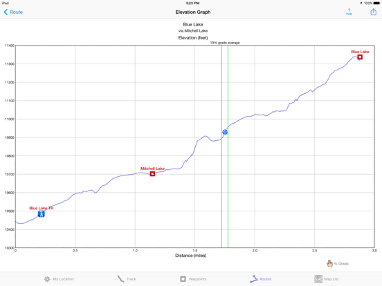
Show an elevation graph of your track or a route. View date, time, average speed and % grade of track points. Measure the area inside a closed path.
Mark waypoints by their position on a topo or satellite map, by searching for a place name or address, by tapping a geotagged photo, or by projecting from a known point. Refine a waypoint position when you arrive.
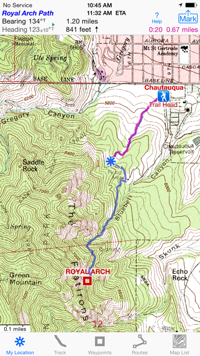
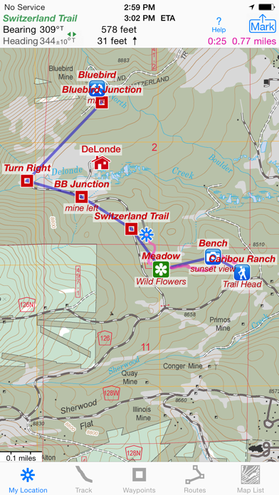
Set a quick GoTo waypoint or a full route & see the heading, direction, distance, elevation change & Estimated Time of Arrival at your destination & intermediate waypoints along the trail.
Create routes using waypoints, recorded tracks, or imported GPX, KML or TCX files. Advanced route editing.
Export GPX and KML waypoint, route, track, and map list files via eMail, Messages, Copy To, AirDrop, iCloud Drive, Google Drive, or the Mac Finder.
Send data to Google Earth.
View and share the sun and moon position and rise & set times for any time and any place on earth.
NO EXTRA CHARGE FOR TOPO MAPS
USA: Newest (2015 or later) US Forest Service FSTopo 24K maps
USGS 24K maps for all 50 states, Guam, Puerto Rico & the US Virgin Islands
USGS 250K & 100K (63K for Alaska) maps for all states
Canada south of 54° latitude: National Resources Canada 50K maps for Alberta, British Columbia, New Brunswick, Nova Scotia & Prince Edward Island, and 18 Canadian National Parks
Download using WiFi or cell service.
Stitches beautiful richly detailed offline topographic map images for seamless coverage across map boundaries.
Store up to 1024 maps to use in the wilderness without cell service. Maps from our server download faster & use less of your monthly data allotment.
Includes map legends.
Print & Share map images overlaid with waypoints, routes & tracks.
Measure distance and direction between any 2 points.
USE THE UNITS YOU PREFER
miles, nautical miles or km. ft or meters
Degrees, Degrees/Minutes, Degrees/Minutes/Seconds or UTM
°True or °Magnetic
HOW TOS
Tap Help in the App
Online Manual on iHikeGPS.com
Twitter: @iHikeGPS
Email developer: lwjames@iHikeGPS.com
WHAT OTHERS SAY
“I am VERY impressed!!!…It pretty much blows…, my previous fave GPS app, out of the water. Your track recording features, fast map downloads, and well thought out interface make it a real winner. It's very sophisticated software, and makes my iPhone just about as good as $600 Garmin… Actually better, in a lot of ways”-John in OR
“Perfect for anyone camping, fishing & hiking, it'll provide great detail when you need it the most…for anyone who takes the great outdoors seriously”-David on HandheldItems.com
“…thank you for developing IHIKE GPS…what a great product it is. I am impressed!…I use it hiking, biking, skiing & Jeeping”-Ammon in CO
DEVICE REQUIREMENTS
No device requires a cellular data plan to use iHikeGPS.
WiFi+cellular iPad 2 & later, and iPhone 4S & later support full navigation.
WiFi-only iPad 2 & later, and iPod touch (5th gen) & later require an iOS-compatible external GPS receiver to show your location in the wilderness & record tracks. View maps using the iOS device alone.
Your dream of hiking adventures reaches new heights with iHikeGPS!
Headed into the wilderness? Always know where you've been, where you are, and where you’re going. Highest quality track recording, best route navigation and most accurate Estimated Time of Arrival of any available hiking app. No sign-up, ads, subscription or in-app purchase required, making this less expensive, less hassle & more privacy respecting than the “free” or subscription apps.
Use for hiking, backpacking, biking, canoeing, kayaking, geocaching, camping, sightseeing, 4WD exploring & hunting. Recommended as the top choice in “Essential Gear for Safe Hiking”.
TRACKS, WAYPOINTS & ROUTES
Record a track as you walk, even in the background. View it on the map. Trip Timer & Odometer.
Show an elevation graph of your track or a route. View date, time, average speed and % grade of track points. Measure the area inside a closed path.
Mark waypoints by their position on a topo or satellite map, by searching for a place name or address, by tapping a geotagged photo, or by projecting from a known point. Refine a waypoint position when you arrive.
Set a quick GoTo waypoint or a full route & see the heading, direction, distance, elevation change & Estimated Time of Arrival at your destination & intermediate waypoints along the trail.
Create routes using waypoints, recorded tracks, or imported GPX, KML or TCX files. Advanced route editing.
Export GPX and KML waypoint, route, track, and map list files via eMail, Messages, Copy To, AirDrop, iCloud Drive, Google Drive, or the Mac Finder.
Send data to Google Earth.
View and share the sun and moon position and rise & set times for any time and any place on earth.
NO EXTRA CHARGE FOR TOPO MAPS
USA: Newest (2015 or later) US Forest Service FSTopo 24K maps
USGS 24K maps for all 50 states, Guam, Puerto Rico & the US Virgin Islands
USGS 250K & 100K (63K for Alaska) maps for all states
Canada south of 54° latitude: National Resources Canada 50K maps for Alberta, British Columbia, New Brunswick, Nova Scotia & Prince Edward Island, and 18 Canadian National Parks
Download using WiFi or cell service.
Stitches beautiful richly detailed offline topographic map images for seamless coverage across map boundaries.
Store up to 1024 maps to use in the wilderness without cell service. Maps from our server download faster & use less of your monthly data allotment.
Includes map legends.
Print & Share map images overlaid with waypoints, routes & tracks.
Measure distance and direction between any 2 points.
USE THE UNITS YOU PREFER
miles, nautical miles or km. ft or meters
Degrees, Degrees/Minutes, Degrees/Minutes/Seconds or UTM
°True or °Magnetic
HOW TOS
Tap Help in the App
Online Manual on iHikeGPS.com
Twitter: @iHikeGPS
Email developer: lwjames@iHikeGPS.com
WHAT OTHERS SAY
“I am VERY impressed!!!…It pretty much blows…, my previous fave GPS app, out of the water. Your track recording features, fast map downloads, and well thought out interface make it a real winner. It's very sophisticated software, and makes my iPhone just about as good as $600 Garmin… Actually better, in a lot of ways”-John in OR
“Perfect for anyone camping, fishing & hiking, it'll provide great detail when you need it the most…for anyone who takes the great outdoors seriously”-David on HandheldItems.com
“…thank you for developing IHIKE GPS…what a great product it is. I am impressed!…I use it hiking, biking, skiing & Jeeping”-Ammon in CO
DEVICE REQUIREMENTS
No device requires a cellular data plan to use iHikeGPS.
WiFi+cellular iPad 2 & later, and iPhone 4S & later support full navigation.
WiFi-only iPad 2 & later, and iPod touch (5th gen) & later require an iOS-compatible external GPS receiver to show your location in the wilderness & record tracks. View maps using the iOS device alone.
Your dream of hiking adventures reaches new heights with iHikeGPS!
 このアプリはiPhone、iPadの両方に対応しています。
カテゴリー
ナビゲーション
ナビゲーション
リリース
2010/2/12
2010/2/12
更新
2021/7/8
2021/7/8
バージョン
9.2.5
9.2.5
言語
英語
英語
サイズ
13.5 MB
13.5 MB
条件
iPhone、iPod touch および iPad 互換 iOS 4.3 以降が必要 iPhone 5 用に最適化済み
iPhone、iPod touch および iPad 互換 iOS 4.3 以降が必要 iPhone 5 用に最適化済み
このバージョンの新機能
I use this app daily on trails in Colorado. I'm continually improving it so it will be even more useful! With this version you can view the moon's phase and you can create a waypoint by simply entering an address.
What's new in iHikeGPS when compared wit
I use this app daily on trails in Colorado. I'm continually improving it so it will be even more useful! With this version you can view the moon's phase and you can create a waypoint by simply entering an address.
What's new in iHikeGPS when compared wit
スクリーンショット - iPhone | iPad
スクリーンショット - iPhone | iPad
James Associates Inc. の他のアプリ » もっと見る
» 目的別iPhoneアプリ検索
- 辞書 » 日本語対応の辞書 » 英和辞典
- 学習 » 英単語 » 英会話 » クイズで楽しく
- スケジュール » 管理 » Googleカレンダー


Yahoo!乗換案内
Yahoo Japan Corp.無料
Google マップ - ナビ、乗換案内
Google LLC無料
Yahoo!カーナビ
Yahoo Japan Corp.無料
乗換NAVITIME(乗換ナビタイム) - 運行情報や路線図..
NAVITIME JAPAN CO.,LTD.無料
Yahoo! MAP-ヤフーマップ
Yahoo Japan Corp.無料
乗換案内
Jorudan Co.,Ltd.無料
賃貸物件検索 SUUMO(スーモ)でお部屋探し
Recruit Co.,Ltd.無料
NAVITIME(乗換と地図の総合ナビ)
NAVITIME JAPAN CO.,LTD.無料
NAVITIMEドライブサポーター - カーナビ&渋滞情報&..
NAVITIME JAPAN CO.,LTD.無料
お部屋探しはライフルホームズ賃貸・マンション・不動産物件検索
LIFULL Co., Ltd無料


CatchApp新着アプリレビュー
 日本縦断てつどうの旅」")
様々な楽しみ方で運転士として成長していく鉄道運転士育成RPG「プラチナ・トレイン(プラトレ) 日本縦断てつどうの旅」
2016-05-17 00:00

日本語にはない英語発音のリスニングを楽しく学べる「発音どっち?英語リスニング 」
2014-12-20 12:00

指先の瞬発力が試されるカジュアルゲーム「早撃ちパニック」をリリース!
2014-12-08 15:21
新着アプリ動画
-
 ¥1500
¥1500
-
 ¥600
¥600
-
 ¥3000
¥3000