


このアプリのYoutube動画がある場合はURLを送信してください。詳細 »
APPLICATION INFO - iPhoneアプリの詳細情報
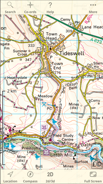
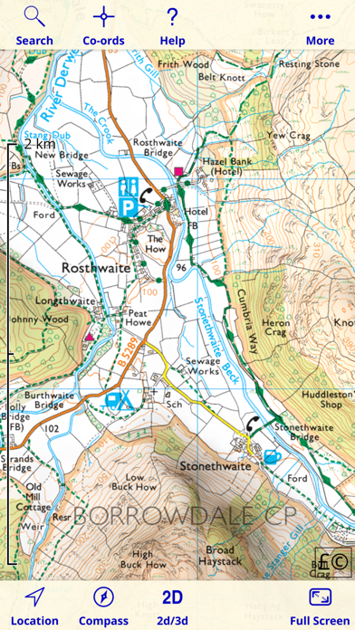
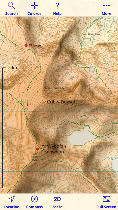
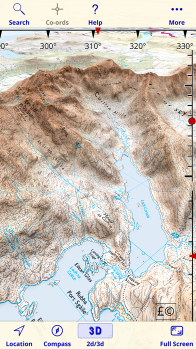
* Unlimited free map downloads based on Ordnance Survey® OpenData, at 1:25,000 and 1:10,000 scales, and now also paid map downloads at 1:50,000, 1:25,000 and 1:10,000 scales, just like the paper maps. * 3D mode ideal for mountains. * Maps downloaded and saved for off-line use. * Mark waypoints, plan routes and record tracks. * Import and export GPX files. * Plot graphs of altitude and speed. * View your photos on the map. * Off-line place, street name and postcode search.
After installing the app, please touch the '?' button to view instructions including how to download detailed maps.
Northern Ireland is not included. The Isle of Man is included only at 1:250,000 (free) and 1:50,000 (paid).
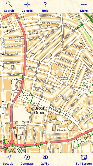
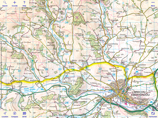
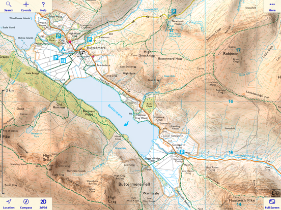
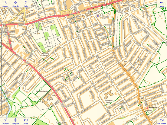
Since 2010, Britain's national mapping agency Ordnance Survey has released a large amount of free map data. UK Map makes much of that data available in a single app. It includes 1:1M MiniScale® and 1:250k road maps, which are built into the app, and 1:25k district maps and 1:10k street maps for the entire country which you can download in 5km by 5km tiles. As the free O.S. data does not include footpaths, this app superimposes footpaths derived from volunteer-collected data from OpenStreetMap.org. These downloads are free of charge.
In addition to the free maps, you can also purchase and download 1:50,000 and 1:25,000 maps that are just like the Ordnance Survey paper maps. You can also purchase 1:10,000 maps for selected urban areas which show more detail than the free 1:10,000 maps.
Once you've downloaded the detailed maps that you need, an internet connection is not required.
The app can load GPX files (for example, from websites, other apps and from nearby devices via AirDrop) and display waypoints, tracks and routes. You can also mark waypoints, plan routes and record tracks within the app, and export them.
You can view graphs of altitude or speed along recorded tracks and routes.
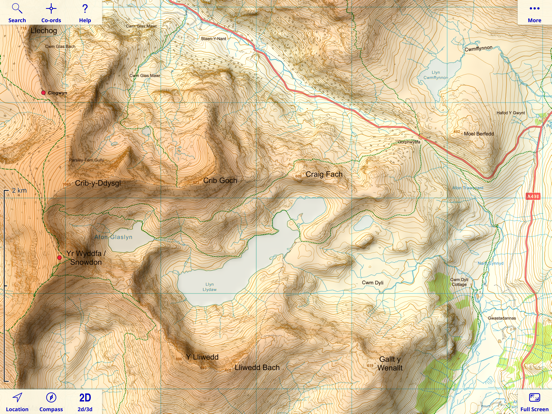
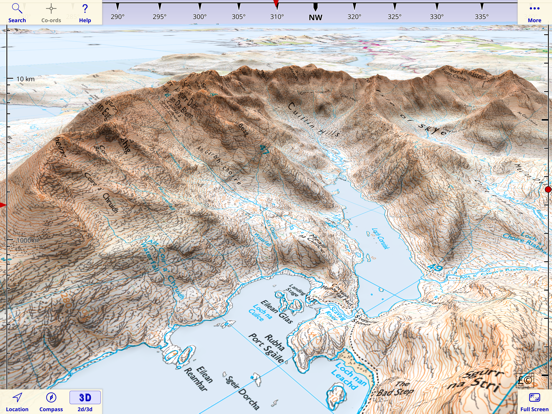
The app has a 3D mode that lets you view the terrain from any viewpoint, useful for visualising hills and mountains.
The app also includes a searchable gazetteer containing over 250,000 place names, 850,000 street names and 1.6 million post codes. All of this data is built in to the app, so this search also works when there is no network connection.
The app also supports the compass and GPS - on those devices that have them - to display your position, orientation and altitude.
Paid maps are licensed for personal and non-commercial use only.
Contains Ordnance Survey data © Crown copyright and database rights 2011 - 2021. Please visit the website for more information - https://ukmapapp.com/
After installing the app, please touch the '?' button to view instructions including how to download detailed maps.
Northern Ireland is not included. The Isle of Man is included only at 1:250,000 (free) and 1:50,000 (paid).
Since 2010, Britain's national mapping agency Ordnance Survey has released a large amount of free map data. UK Map makes much of that data available in a single app. It includes 1:1M MiniScale® and 1:250k road maps, which are built into the app, and 1:25k district maps and 1:10k street maps for the entire country which you can download in 5km by 5km tiles. As the free O.S. data does not include footpaths, this app superimposes footpaths derived from volunteer-collected data from OpenStreetMap.org. These downloads are free of charge.
In addition to the free maps, you can also purchase and download 1:50,000 and 1:25,000 maps that are just like the Ordnance Survey paper maps. You can also purchase 1:10,000 maps for selected urban areas which show more detail than the free 1:10,000 maps.
Once you've downloaded the detailed maps that you need, an internet connection is not required.
The app can load GPX files (for example, from websites, other apps and from nearby devices via AirDrop) and display waypoints, tracks and routes. You can also mark waypoints, plan routes and record tracks within the app, and export them.
You can view graphs of altitude or speed along recorded tracks and routes.
The app has a 3D mode that lets you view the terrain from any viewpoint, useful for visualising hills and mountains.
The app also includes a searchable gazetteer containing over 250,000 place names, 850,000 street names and 1.6 million post codes. All of this data is built in to the app, so this search also works when there is no network connection.
The app also supports the compass and GPS - on those devices that have them - to display your position, orientation and altitude.
Paid maps are licensed for personal and non-commercial use only.
Contains Ordnance Survey data © Crown copyright and database rights 2011 - 2021. Please visit the website for more information - https://ukmapapp.com/
 このアプリはiPhone、iPadの両方に対応しています。
カテゴリー
ナビゲーション
ナビゲーション
リリース
2010/4/13
2010/4/13
更新
2021/6/21
2021/6/21
バージョン
4.4
4.4
言語
英語
英語
サイズ
306 MB
306 MB
条件
iPhone、iPod touch および iPad 互換 iOS 4.0 以降が必要
iPhone、iPod touch および iPad 互換 iOS 4.0 以降が必要
このバージョンの新機能
This update provides new versions of the paid 1:25,000 maps.
The built-in 1:250,000 map has been updated to the latest version.
This update provides new versions of the paid 1:25,000 maps.
The built-in 1:250,000 map has been updated to the latest version.
スクリーンショット - iPhone | iPad
スクリーンショット - iPhone | iPad
Mappendix Limited の他のアプリ » もっと見る
» 目的別iPhoneアプリ検索
- 辞書 » 日本語対応の辞書 » 英和辞典
- 学習 » 英単語 » 英会話 » クイズで楽しく
- スケジュール » 管理 » Googleカレンダー


Yahoo!乗換案内
Yahoo Japan Corp.無料
Google マップ - ナビ、乗換案内
Google LLC無料
Yahoo!カーナビ
Yahoo Japan Corp.無料
乗換NAVITIME(乗換ナビタイム) - 運行情報や路線図..
NAVITIME JAPAN CO.,LTD.無料
Yahoo! MAP-ヤフーマップ
Yahoo Japan Corp.無料
乗換案内
Jorudan Co.,Ltd.無料
賃貸物件検索 SUUMO(スーモ)でお部屋探し
Recruit Co.,Ltd.無料
NAVITIME(乗換と地図の総合ナビ)
NAVITIME JAPAN CO.,LTD.無料
NAVITIMEドライブサポーター - カーナビ&渋滞情報&..
NAVITIME JAPAN CO.,LTD.無料
お部屋探しはライフルホームズ賃貸・マンション・不動産物件検索
LIFULL Co., Ltd無料


CatchApp新着アプリレビュー
 日本縦断てつどうの旅」")
様々な楽しみ方で運転士として成長していく鉄道運転士育成RPG「プラチナ・トレイン(プラトレ) 日本縦断てつどうの旅」
2016-05-17 00:00

日本語にはない英語発音のリスニングを楽しく学べる「発音どっち?英語リスニング 」
2014-12-20 12:00

指先の瞬発力が試されるカジュアルゲーム「早撃ちパニック」をリリース!
2014-12-08 15:21
新着アプリ動画
-
 ¥1500
¥1500
-
 ¥600
¥600
-
 ¥3000
¥3000