


このアプリのYoutube動画がある場合はURLを送信してください。詳細 »
APPLICATION INFO - iPhoneアプリの詳細情報

-

- Share on Tumblr
- Check
- ツイート
WingX Pro7's simple subscription model:
● $74.95 annual subscription (or $199.95 for 3 years)
● $74.95 for Advanced IFR Subscription
● Free: 30-day Free Period
● Free: Synthetic Vision and Fuel Prices (with current subscription)
Annual Subscription
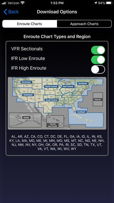
Includes VFR Sectionals, IFR Enroute Low and High, WACs, TACs, Flyway, Helicopter, Grand Canyon, and IFR Area charts plus APDs (geo-referenced), IAPs, etc
Advanced IFR Subscription
IAP geo-referencing, IAP Routing and ChartTouch
New!
● Aircraft Icons including a revolutionary helicopter!
● Stadium TFRs
● Download flight plans directly from AOPA
● FAA Airman Certification Standards (ACS) and Practical Test Standards (PTS) Documents
● Appy Awards (Mar 2016) - Best Mapping/Location-Based App
● Aviation Consumer (July 2013) - "WingX Pro7 is Best iPad App of 2012!"
● Aviation Consumer (Feb 2013) - "Five Top Apps - WingX Pro7 is a Standout"
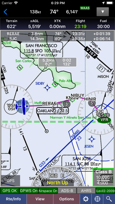
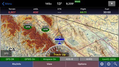
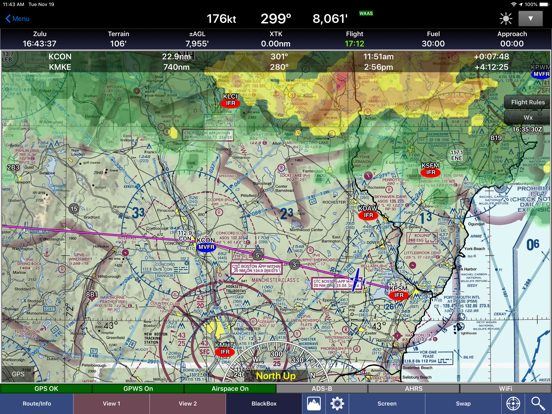
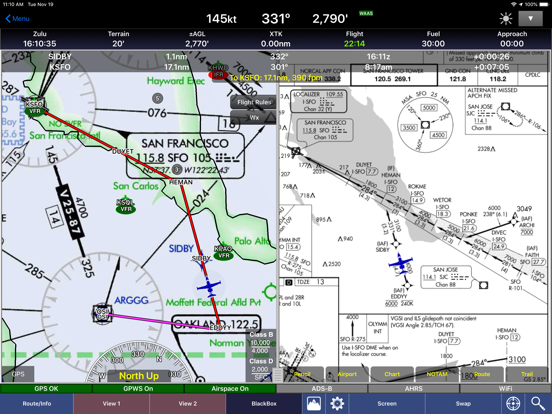
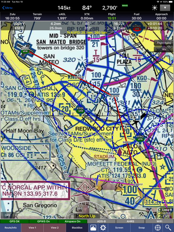
GPS-Enabled Moving Map
● VFR Sectionals, IFR Enroute Low and High, WACs, TACs, Flyways, Helicopter, Grand Canyon, and IFR Area charts
● Wx Overlays including NEXRAD composite and many other weather overlay types with animation, transparency, and low-bandwidth option (e.g. hotel rooms)
● DP, STAR, and IAP Routing (iPad only for now)
● North Up or Track Up
● Split Screen
● Business locations on Airport Diagrams
● ADS-B In-Flight Weather and Traffic
● Support for Pebble, Pebble Steel, and Pebble Time watches
● X-Plane and MS Flight Sim compatible
● Ground Proximity Warning System (GPWS) - terrain and obstacles
● SmartTaxi™ - advanced taxi warning system
● FlightShare™ - share routes on the ground or in the air!
● traca™ Technology - draw the route with your finger
● WingX Rewind™ - record and playback flights including GPS, AHRS, and Pitot-Static. email flights to friends and CFIs!
● Auto Airport Diagram (Auto APD) auto-switches to Airport Diagram
● Class B Transitions
● Search And Rescue Grids and Patterns (old/new format) - Parallel, Square, Sector, and Auto Fill Grid - supports MGRS
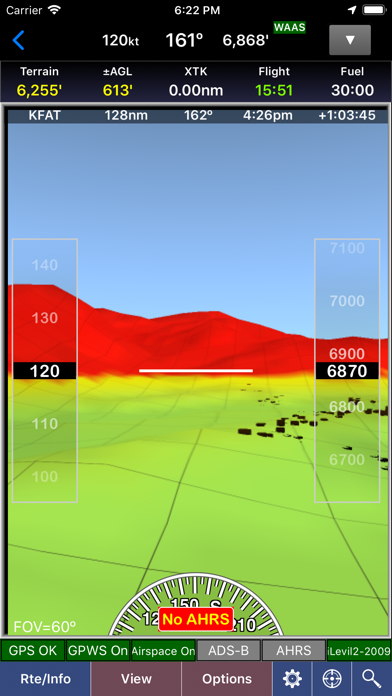
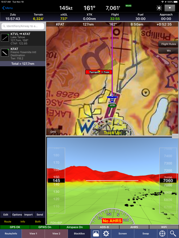
● Overlay terrain and obstacles (terrain up to 60N)
● Easy time/distance to point info
● State Lines
● Aspen Connected Panel
● Airspace Overlay and Information
● Airspace Notifications
● Passive RADAR Altimeter - Terrain Elevation or AGL
● Terrain Profile View - with climb angle and 500fpm descent lines
● AHRS-driven Attitude Indicator
● Built-in Simulator
● Extra dimming for night operations
● Rubber-Banding
● User-Defined Waypoints; e.g. SJC09015, N37.5W119.56 etc
● Multi-Page Notepad with Undo
● Knots, MPH, km/h
● Runway Extensions and Traffic Patterns
● Easy GPS Calibration - tap on moving map's altitude
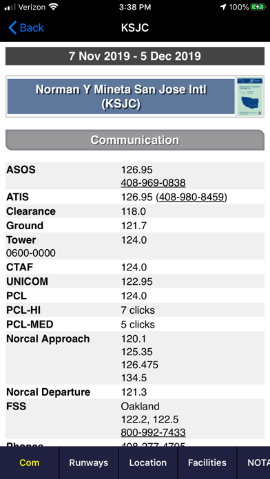
● Comprehensive A/FD and AOPA Directory
● Multiple Count-Up/Down timers
Approach Charts
● Print charts wirelessly
● Rotate DPs and STARs easily
● Draw on the approach chart with your finger
Wx Text
● Color-coded and decoded METARs, TAFs, winds/temps aloft
● Includes Alaska and Hawaii
● METAR Density Altitude and Freezing Levels
Route Planning
● Victor Airways, Jetways, DPs, STARs, and even IAPs!
● Waypoints automatically inserted in correct position
● Total and Longer Than Direct distances
● Flight Log shows Headings, GS, ETE, Fuel Burn using winds aloft
● Optimize Altitude for winds aloft
DUATS
● Flight Plans and Weather Briefings with DUATS. Can be reused for fast filing
● File, Close, and Cancel flight plans
● Route and Area Weather Briefings
● Aircraft Manager for auto-fill
● Part 135 friendly
E6B
● TAS
● Conversions
● Distance-Speed-Time
● Pressure/Density Altitude
● Winds Aloft
● Runway Winds
● IFR Climb
● Descent Rate
Documents
● FARs including Parts 1, 43, 61, 91, 119, 121, 135, 137, 141, NTSB 830, 1552, and 1562
● Parts of the AIM
● AC61-65E - Including Endorsements
● AC61-67C - Stall and Spin Awarenes
● Pilot/Controller Glossary
● Aeronautical Contractions
● User-Documents
Integrated Help System
● Built-in mini-manual
Note: Continued use of GPS running in the background can dramatically decrease battery life.
Follow us on twitter: mobilewingx
● $74.95 annual subscription (or $199.95 for 3 years)
● $74.95 for Advanced IFR Subscription
● Free: 30-day Free Period
● Free: Synthetic Vision and Fuel Prices (with current subscription)
Annual Subscription
Includes VFR Sectionals, IFR Enroute Low and High, WACs, TACs, Flyway, Helicopter, Grand Canyon, and IFR Area charts plus APDs (geo-referenced), IAPs, etc
Advanced IFR Subscription
IAP geo-referencing, IAP Routing and ChartTouch
New!
● Aircraft Icons including a revolutionary helicopter!
● Stadium TFRs
● Download flight plans directly from AOPA
● FAA Airman Certification Standards (ACS) and Practical Test Standards (PTS) Documents
● Appy Awards (Mar 2016) - Best Mapping/Location-Based App
● Aviation Consumer (July 2013) - "WingX Pro7 is Best iPad App of 2012!"
● Aviation Consumer (Feb 2013) - "Five Top Apps - WingX Pro7 is a Standout"
GPS-Enabled Moving Map
● VFR Sectionals, IFR Enroute Low and High, WACs, TACs, Flyways, Helicopter, Grand Canyon, and IFR Area charts
● Wx Overlays including NEXRAD composite and many other weather overlay types with animation, transparency, and low-bandwidth option (e.g. hotel rooms)
● DP, STAR, and IAP Routing (iPad only for now)
● North Up or Track Up
● Split Screen
● Business locations on Airport Diagrams
● ADS-B In-Flight Weather and Traffic
● Support for Pebble, Pebble Steel, and Pebble Time watches
● X-Plane and MS Flight Sim compatible
● Ground Proximity Warning System (GPWS) - terrain and obstacles
● SmartTaxi™ - advanced taxi warning system
● FlightShare™ - share routes on the ground or in the air!
● traca™ Technology - draw the route with your finger
● WingX Rewind™ - record and playback flights including GPS, AHRS, and Pitot-Static. email flights to friends and CFIs!
● Auto Airport Diagram (Auto APD) auto-switches to Airport Diagram
● Class B Transitions
● Search And Rescue Grids and Patterns (old/new format) - Parallel, Square, Sector, and Auto Fill Grid - supports MGRS
● Overlay terrain and obstacles (terrain up to 60N)
● Easy time/distance to point info
● State Lines
● Aspen Connected Panel
● Airspace Overlay and Information
● Airspace Notifications
● Passive RADAR Altimeter - Terrain Elevation or AGL
● Terrain Profile View - with climb angle and 500fpm descent lines
● AHRS-driven Attitude Indicator
● Built-in Simulator
● Extra dimming for night operations
● Rubber-Banding
● User-Defined Waypoints; e.g. SJC09015, N37.5W119.56 etc
● Multi-Page Notepad with Undo
● Knots, MPH, km/h
● Runway Extensions and Traffic Patterns
● Easy GPS Calibration - tap on moving map's altitude
● Comprehensive A/FD and AOPA Directory
● Multiple Count-Up/Down timers
Approach Charts
● Print charts wirelessly
● Rotate DPs and STARs easily
● Draw on the approach chart with your finger
Wx Text
● Color-coded and decoded METARs, TAFs, winds/temps aloft
● Includes Alaska and Hawaii
● METAR Density Altitude and Freezing Levels
Route Planning
● Victor Airways, Jetways, DPs, STARs, and even IAPs!
● Waypoints automatically inserted in correct position
● Total and Longer Than Direct distances
● Flight Log shows Headings, GS, ETE, Fuel Burn using winds aloft
● Optimize Altitude for winds aloft
DUATS
● Flight Plans and Weather Briefings with DUATS. Can be reused for fast filing
● File, Close, and Cancel flight plans
● Route and Area Weather Briefings
● Aircraft Manager for auto-fill
● Part 135 friendly
E6B
● TAS
● Conversions
● Distance-Speed-Time
● Pressure/Density Altitude
● Winds Aloft
● Runway Winds
● IFR Climb
● Descent Rate
Documents
● FARs including Parts 1, 43, 61, 91, 119, 121, 135, 137, 141, NTSB 830, 1552, and 1562
● Parts of the AIM
● AC61-65E - Including Endorsements
● AC61-67C - Stall and Spin Awarenes
● Pilot/Controller Glossary
● Aeronautical Contractions
● User-Documents
Integrated Help System
● Built-in mini-manual
Note: Continued use of GPS running in the background can dramatically decrease battery life.
Follow us on twitter: mobilewingx
 このアプリはiPhone、iPadの両方に対応しています。
カテゴリー
ナビゲーション
ナビゲーション
リリース
2010/6/30
2010/6/30
更新
2016/9/5
2016/9/5
バージョン
8.6.8
8.6.8
言語
英語
英語
サイズ
19.8 MB
19.8 MB
条件
iPhone、iPod touch および iPad 互換 iOS 4.3 以降が必要 iPhone 5 用に最適化済み
iPhone、iPod touch および iPad 互換 iOS 4.3 以降が必要 iPhone 5 用に最適化済み
このバージョンの新機能
Improvements and Fixes:
● Aircraft symbol in some cases might not initially appear
● Search and Rescue grid lines and labeling improvements and fixes
Improvements and Fixes:
● Aircraft symbol in some cases might not initially appear
● Search and Rescue grid lines and labeling improvements and fixes
スクリーンショット - iPhone | iPad
スクリーンショット - iPhone | iPad
» 目的別iPhoneアプリ検索
- 辞書 » 日本語対応の辞書 » 英和辞典
- 学習 » 英単語 » 英会話 » クイズで楽しく
- スケジュール » 管理 » Googleカレンダー


Yahoo!乗換案内
Yahoo Japan Corp.無料
Google マップ - ナビ、乗換案内
Google LLC無料
Yahoo!カーナビ
Yahoo Japan Corp.無料
乗換NAVITIME(乗換ナビタイム) - 運行情報や路線図..
NAVITIME JAPAN CO.,LTD.無料
Yahoo! MAP-ヤフーマップ
Yahoo Japan Corp.無料
乗換案内
Jorudan Co.,Ltd.無料
賃貸物件検索 SUUMO(スーモ)でお部屋探し
Recruit Co.,Ltd.無料
NAVITIME(乗換と地図の総合ナビ)
NAVITIME JAPAN CO.,LTD.無料
NAVITIMEドライブサポーター - カーナビ&渋滞情報&..
NAVITIME JAPAN CO.,LTD.無料
お部屋探しはライフルホームズ賃貸・マンション・不動産物件検索
LIFULL Co., Ltd無料


CatchApp新着アプリレビュー
 日本縦断てつどうの旅」")
様々な楽しみ方で運転士として成長していく鉄道運転士育成RPG「プラチナ・トレイン(プラトレ) 日本縦断てつどうの旅」
2016-05-17 00:00

日本語にはない英語発音のリスニングを楽しく学べる「発音どっち?英語リスニング 」
2014-12-20 12:00

指先の瞬発力が試されるカジュアルゲーム「早撃ちパニック」をリリース!
2014-12-08 15:21
新着アプリ動画
-
 ¥1500
¥1500
-
 ¥600
¥600
-
 ¥3000
¥3000