


このアプリのYoutube動画がある場合はURLを送信してください。詳細 »
APPLICATION INFO - iPhoneアプリの詳細情報
Sea Weather Professional provides nautical Information for the Atlantic, Pacific, North Sea, Baltic Sea and the Mediterranean Sea for professional planning and navigation. Open data from European & US weather services is enhanced for your mobile device.
Get weather reports, forecasts, maps, and NAVTEX radio messages from many nautical areas. Your One-stop-solution available for all devices (iPhone, iPad & iPod).
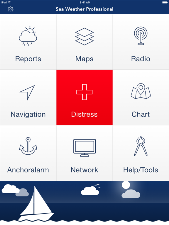
FEATURES:
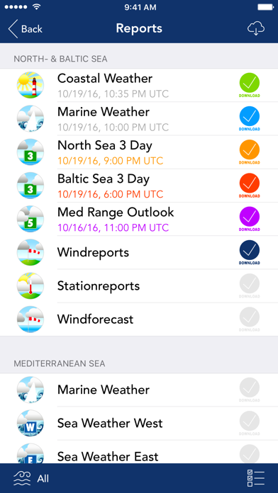
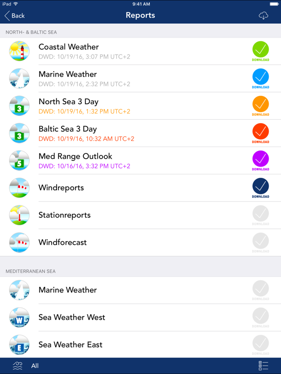
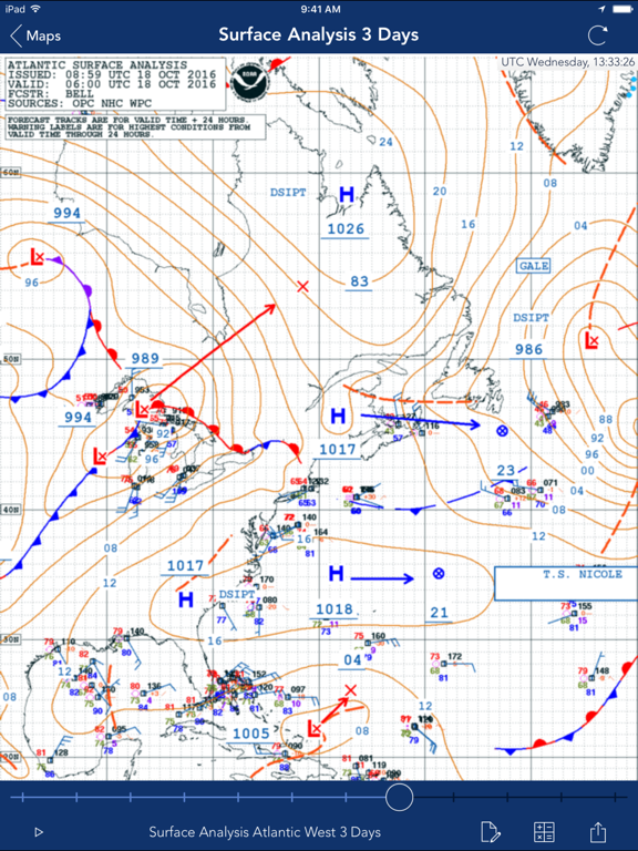
– Marine weather reports and maps for Atlantic, Pacific, North Sea, Baltic Sea and Mediterranean Sea
– e.g. Coastal Weather Report, Shipping Forecast, Station reports, Wind Forecast, 3 Day Sea Weather Preview
– Wind & wave information for all three nautical areas
– NAVTEX radio messages
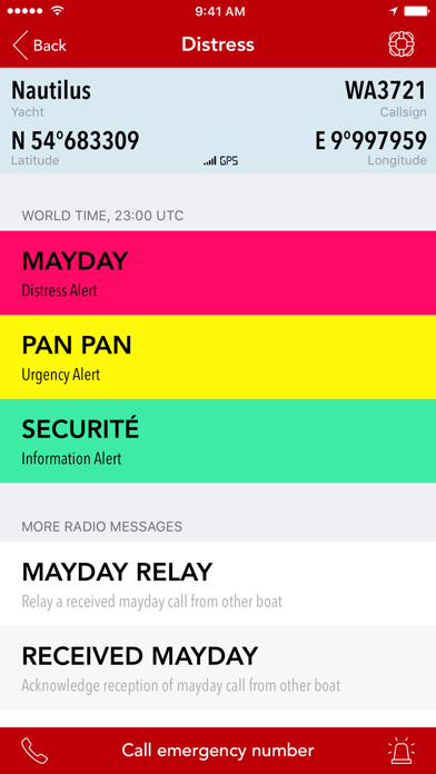
– Distress Assistant for calling MAYDAY / help & sending S O S
– Navigation Head Up Display
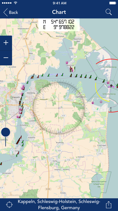
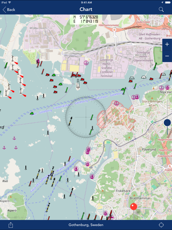
– OpenSeaMap the free nautical sea chart
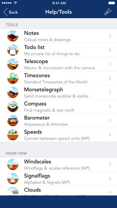
– Checklists, Windcalculator, Nautical Signal Flags, Morsecodes, Clouds
– Sharing of reports and maps
– Offline Datastorage: Store reports, maps and other resources to access when offline
– Turbo Download: One-tap-update of all weather data (reports, maps, NAVTEX radio messages)
– Night vision: Red-Light-Vision ensures that your eyes keep night vision
– Anchor alarm: Monitor and log safety of your yacht position in background
– Waterlevels: Get access to the latest levels of inshore waterways
– European Reports: Get access to all kind of available marine weather info in Europe
– USA Reports: Reports & maps for United States Atlantic, Pacific & Alaska regions
– Todolist: Keep track of what needs to be done on board & proritize with colorful tags
– Telescope: Use the built in camera to magnify things far away
– Timezones: World Timezones for a lot of major cities
– Morse telegraph: Morse any message via audio or LED flashlight
– Compass: Easy to use compass whenever needed
– Barometer: Measure air pressure & keep history of measurements
– Distress-Voice-Assistant: In case of distress let the app speak for you
– Weatherinformation for cities worldwide
– Unlimited use of Seaweather Professional Nautical Network
– Frequent servicedata updates for the app
REPORTS & MAPS COVER FOLLOWING SEA AREAS:
Atlantic, Pacific, Alaska, East Frisian coast, estuary, Helgoland, North Frisian coast, the river Elbe between Hamburg and Cuxhaven, Flensburg to Fehmarn Fehmarn to the east of Rügen, east of Rügen, German Bight, Western Baltic Sea, Southern Baltic Sea, Southwest North Sea, fishing, Forties, Viking, Utsira, Skagerrak, Kattegat, the Belts and the Sound, Bodden East, South-eastern Baltic Sea, central Baltic Sea, Northern Baltic Sea, Gulf of Riga, Engl.Kanal-West-East Engl.Kanal, IJsselmeer, Canary Islands, Alborán / Gibraltar, Palos (between Spain and South West Algeria), Balearic Islands, west of Corsica / Sardinia, Gulf of Lions, Ligurian sea, Tyrrhenian sea, Adriatic Sea, Ionian Sea, Aegean Sea, Taurus, Biscay
ATTENTION:
– Use of anchoralarm product is only recommended under safe conditions (i.e. strong GPS signal)
– Continuous use of the Locationservices/GPS (e.g. using anchoralarm and navigational instruments) will drain the battery significantly faster than under normal conditions.
LICENSE:
Product uses icons from http://icons8.com/ under Creative Commons Attribution-NoDerivs 3.0 Unported License.
Get weather reports, forecasts, maps, and NAVTEX radio messages from many nautical areas. Your One-stop-solution available for all devices (iPhone, iPad & iPod).
FEATURES:
– Marine weather reports and maps for Atlantic, Pacific, North Sea, Baltic Sea and Mediterranean Sea
– e.g. Coastal Weather Report, Shipping Forecast, Station reports, Wind Forecast, 3 Day Sea Weather Preview
– Wind & wave information for all three nautical areas
– NAVTEX radio messages
– Distress Assistant for calling MAYDAY / help & sending S O S
– Navigation Head Up Display
– OpenSeaMap the free nautical sea chart
– Checklists, Windcalculator, Nautical Signal Flags, Morsecodes, Clouds
– Sharing of reports and maps
– Offline Datastorage: Store reports, maps and other resources to access when offline
– Turbo Download: One-tap-update of all weather data (reports, maps, NAVTEX radio messages)
– Night vision: Red-Light-Vision ensures that your eyes keep night vision
– Anchor alarm: Monitor and log safety of your yacht position in background
– Waterlevels: Get access to the latest levels of inshore waterways
– European Reports: Get access to all kind of available marine weather info in Europe
– USA Reports: Reports & maps for United States Atlantic, Pacific & Alaska regions
– Todolist: Keep track of what needs to be done on board & proritize with colorful tags
– Telescope: Use the built in camera to magnify things far away
– Timezones: World Timezones for a lot of major cities
– Morse telegraph: Morse any message via audio or LED flashlight
– Compass: Easy to use compass whenever needed
– Barometer: Measure air pressure & keep history of measurements
– Distress-Voice-Assistant: In case of distress let the app speak for you
– Weatherinformation for cities worldwide
– Unlimited use of Seaweather Professional Nautical Network
– Frequent servicedata updates for the app
REPORTS & MAPS COVER FOLLOWING SEA AREAS:
Atlantic, Pacific, Alaska, East Frisian coast, estuary, Helgoland, North Frisian coast, the river Elbe between Hamburg and Cuxhaven, Flensburg to Fehmarn Fehmarn to the east of Rügen, east of Rügen, German Bight, Western Baltic Sea, Southern Baltic Sea, Southwest North Sea, fishing, Forties, Viking, Utsira, Skagerrak, Kattegat, the Belts and the Sound, Bodden East, South-eastern Baltic Sea, central Baltic Sea, Northern Baltic Sea, Gulf of Riga, Engl.Kanal-West-East Engl.Kanal, IJsselmeer, Canary Islands, Alborán / Gibraltar, Palos (between Spain and South West Algeria), Balearic Islands, west of Corsica / Sardinia, Gulf of Lions, Ligurian sea, Tyrrhenian sea, Adriatic Sea, Ionian Sea, Aegean Sea, Taurus, Biscay
ATTENTION:
– Use of anchoralarm product is only recommended under safe conditions (i.e. strong GPS signal)
– Continuous use of the Locationservices/GPS (e.g. using anchoralarm and navigational instruments) will drain the battery significantly faster than under normal conditions.
LICENSE:
Product uses icons from http://icons8.com/ under Creative Commons Attribution-NoDerivs 3.0 Unported License.
 このアプリはiPhone、iPadの両方に対応しています。
カテゴリー
天気
天気
リリース
2010/8/3
2010/8/3
更新
2017/10/2
2017/10/2
バージョン
6.3
6.3
言語
英語, ドイツ語
英語, ドイツ語
サイズ
101 MB
101 MB
条件
iPhone、iPod touch および iPad 互換 iOS 4.0 以降が必要
iPhone、iPod touch および iPad 互換 iOS 4.0 以降が必要
このバージョンの新機能
- Improvements and bugfixes
- Improvements and bugfixes
スクリーンショット - iPhone | iPad
スクリーンショット - iPhone | iPad
appdoctors UG の他のアプリ » もっと見る
» 目的別iPhoneアプリ検索
- 辞書 » 日本語対応の辞書 » 英和辞典
- 学習 » 英単語 » 英会話 » クイズで楽しく
- スケジュール » 管理 » Googleカレンダー


気象ライブ - 地域の天気予報
Easy Tiger Apps, LLC.無料
Yahoo!天気
Yahoo Japan Corp.無料
天気に関するリアルタイムの詳しいニュースをお届けします
The Weather Channel Interactiv..無料
おしゃれ天気
MEDIANO Co.,Ltd.無料
そら案内 4
feedtailor Inc.無料
Yahoo!防災速報
Yahoo Japan Corp.無料
ウェザーニュース
Weathernews Inc.無料
Weather Underground: Local Map
Weather Underground, LLC無料
湿度計
KYU TAE PARK無料
天気予報 - レインレーダー&地図
Tasmanic Editions無料


CatchApp新着アプリレビュー
 日本縦断てつどうの旅」")
様々な楽しみ方で運転士として成長していく鉄道運転士育成RPG「プラチナ・トレイン(プラトレ) 日本縦断てつどうの旅」
2016-05-17 00:00

日本語にはない英語発音のリスニングを楽しく学べる「発音どっち?英語リスニング 」
2014-12-20 12:00

指先の瞬発力が試されるカジュアルゲーム「早撃ちパニック」をリリース!
2014-12-08 15:21
新着アプリ動画
-
 ¥1500
¥1500
-
 ¥600
¥600
-
 ¥3000
¥3000