


このアプリのYoutube動画がある場合はURLを送信してください。詳細 »
APPLICATION INFO - iPhoneアプリの詳細情報
iGIS - The world's first and leading iOS GIS.
True GIS functionality is now available on the iPad! Your iPad. Your data. Your maps.
iGIS represents a new era in mobile GIS solutions by enabling users to load, view, investigate, create and export their own data over a background of map service imagery.
Importing data is easy with our unique data import facility supporting Mac, PC and Linux or via the USB cable. ESRI Shapefiles (.shp) are supported at the moment.
Great for field work as your spatial data is stored on the iPad, so there is no need for an Internet connection to see your data. We also support over 3000 projections, so there is no need for data re-projection.
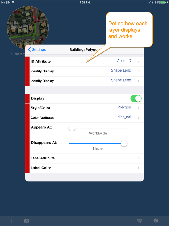
We include support for multiple layers of points, lines, and polygons and imagery – all styled as you like.
Add comments to your maps - A point layer is added with a name and description field. You can add or edit any of your layers - and even define your own data entry forms with dropdown lists for codes, etc.
Export your layers to ESRI shapefiles for use back in your enterprise.
Other features include:
- Great speed, using our multi-threaded map renderer.
- Support for large datasets.
- Add your own imagery
- Import and export of ESRI Shapefiles.
- Display current GPS location in your chosen projection ( + compass)
- Zoom to current location
- Zoom to data extent
- Map Pan, zoom in, zoom out
- Changeable drawing styles for a layer: size, color, transparency
- Set the draw order and visibility of map layers
- Set the zoom scale for layers via a simple slider
- Select and interrogate feature attributes via point and click
This application is designed for GIS professionals and an understanding of some basic GIS concepts such as layers, shapefiles, projections etc, would make using iGIS simpler. Please let us know if concepts in iGIS are unclear.
We know there’s a lot more functionality that we haven’t included. Let us know what features you’d like to see added or improved.
iGIS can use the GPS in the background. Continued use of GPS running in the background can dramatically decrease battery life.
Thanks for your interest,
The Geometry Team
True GIS functionality is now available on the iPad! Your iPad. Your data. Your maps.
iGIS represents a new era in mobile GIS solutions by enabling users to load, view, investigate, create and export their own data over a background of map service imagery.
Importing data is easy with our unique data import facility supporting Mac, PC and Linux or via the USB cable. ESRI Shapefiles (.shp) are supported at the moment.
Great for field work as your spatial data is stored on the iPad, so there is no need for an Internet connection to see your data. We also support over 3000 projections, so there is no need for data re-projection.
We include support for multiple layers of points, lines, and polygons and imagery – all styled as you like.
Add comments to your maps - A point layer is added with a name and description field. You can add or edit any of your layers - and even define your own data entry forms with dropdown lists for codes, etc.
Export your layers to ESRI shapefiles for use back in your enterprise.
Other features include:
- Great speed, using our multi-threaded map renderer.
- Support for large datasets.
- Add your own imagery
- Import and export of ESRI Shapefiles.
- Display current GPS location in your chosen projection ( + compass)
- Zoom to current location
- Zoom to data extent
- Map Pan, zoom in, zoom out
- Changeable drawing styles for a layer: size, color, transparency
- Set the draw order and visibility of map layers
- Set the zoom scale for layers via a simple slider
- Select and interrogate feature attributes via point and click
This application is designed for GIS professionals and an understanding of some basic GIS concepts such as layers, shapefiles, projections etc, would make using iGIS simpler. Please let us know if concepts in iGIS are unclear.
We know there’s a lot more functionality that we haven’t included. Let us know what features you’d like to see added or improved.
iGIS can use the GPS in the background. Continued use of GPS running in the background can dramatically decrease battery life.
Thanks for your interest,
The Geometry Team
※iPadでご利用できるアプリです。
カテゴリー
ナビゲーション
ナビゲーション
リリース
2010/8/25
2010/8/25
更新
2016/9/11
2016/9/11
バージョン
8.2.2
8.2.2
言語
英語
英語
サイズ
77.2 MB
77.2 MB
条件
iPad 互換iOS 4.0 以降が必要
iPad 互換iOS 4.0 以降が必要
このバージョンの新機能
- Works on iPad Pro in split screen mode
- Fixed issue with tracking GPS
- Works on iPad Pro in split screen mode
- Fixed issue with tracking GPS
スクリーンショット
» 目的別iPhoneアプリ検索
- 辞書 » 日本語対応の辞書 » 英和辞典
- 学習 » 英単語 » 英会話 » クイズで楽しく
- スケジュール » 管理 » Googleカレンダー


Yahoo!乗換案内
Yahoo Japan Corp.無料
Google マップ - ナビ、乗換案内
Google LLC無料
Yahoo!カーナビ
Yahoo Japan Corp.無料
乗換NAVITIME(乗換ナビタイム) - 運行情報や路線図..
NAVITIME JAPAN CO.,LTD.無料
Yahoo! MAP-ヤフーマップ
Yahoo Japan Corp.無料
乗換案内
Jorudan Co.,Ltd.無料
賃貸物件検索 SUUMO(スーモ)でお部屋探し
Recruit Co.,Ltd.無料
NAVITIME(乗換と地図の総合ナビ)
NAVITIME JAPAN CO.,LTD.無料
NAVITIMEドライブサポーター - カーナビ&渋滞情報&..
NAVITIME JAPAN CO.,LTD.無料
お部屋探しはライフルホームズ賃貸・マンション・不動産物件検索
LIFULL Co., Ltd無料


CatchApp新着アプリレビュー
 日本縦断てつどうの旅」")
様々な楽しみ方で運転士として成長していく鉄道運転士育成RPG「プラチナ・トレイン(プラトレ) 日本縦断てつどうの旅」
2016-05-17 00:00

日本語にはない英語発音のリスニングを楽しく学べる「発音どっち?英語リスニング 」
2014-12-20 12:00

指先の瞬発力が試されるカジュアルゲーム「早撃ちパニック」をリリース!
2014-12-08 15:21
新着アプリ動画
-
 ¥1500
¥1500
-
 ¥600
¥600
-
 ¥3000
¥3000