


このアプリのYoutube動画がある場合はURLを送信してください。詳細 »
APPLICATION INFO - iPhoneアプリの詳細情報
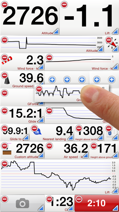
Flyskyhy forms your flight instrument during flight and shows all information you need for that. You get the normal data like altitude, climb rate, ground speed, and glide angle. But it also calculates and shows the current wind direction and strength, very important for your safety.
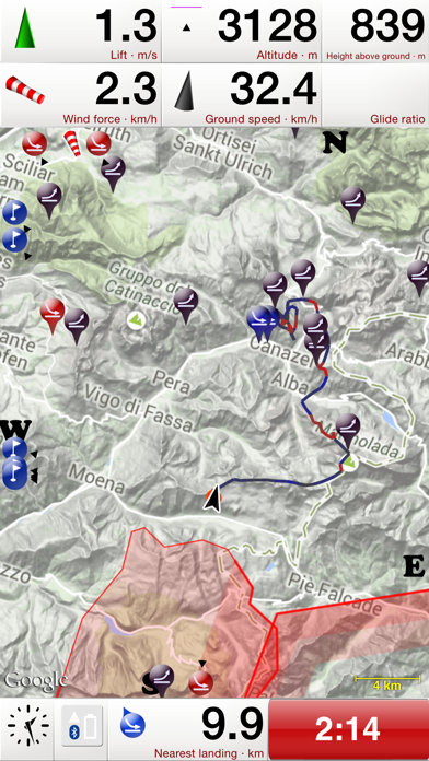
A moving and rotating map shows your current flying position and flight trail. It indicates where you have gone up (in a thermal), and where you have had faster than normal decline. With that, you can easily find back that thermal that you lost. The map also shows the nearest known landing spots, and whether they are reachable by normal glide, given your current altitude and wind direction.
Integration with Bluetooth varios SensBox, FlyNet, GoFly iPico, XC-Tracer, BlueFlyVario, or SkyDrop gives accurate altitude and lift information. That turns your iPhone into an full-fletched GPS-vario, including vario tones.
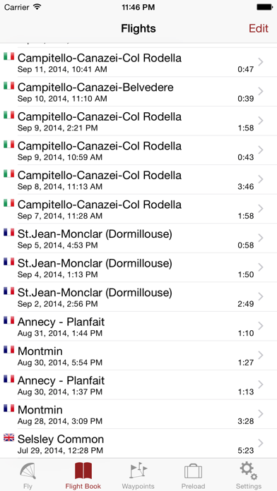
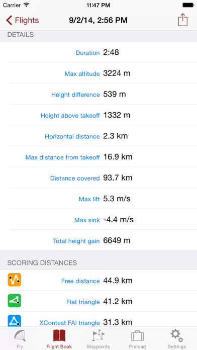
The app makes a full log of your flight, that can be analyzed afterwards. Besides normal data like start and landing positions, duration of flight, and an altitude graph of the flight, Flyskyhy also calculates the scoring distances for you. So you can immediately see whether you have broken that FAI triangle record.
Your live location is reported on livetrack24.com or loctome.com if you desire, so anybody can follow your flight while it is happening. If you are flying together with friends, then their location is shown on your map during your flight. So you never have to wonder anymore whether they are in front of or behind you.
The flight display has multiple screens which are all fully configurable. You can move all elements to other spots, delete and add elements, and resize them.
Through in-app purchases, the app also supports airspaces and waypoints.
The app is optimised for paragliding and hang gliders, but can be used with all kinds of airsports.
Main features during the flight;
• Altitude, climb rate, ground speed, air speed, direction, glide angle and many more
• Wind strength and direction
• Moving map of the flying area
• Spots where you have had lift, great for thermal coring
• Shows whether you can still reach a landing spot with the current altitude and wind
• Live tracking of your flight on livetrack24.com or loctome.com
• Shows live location of your friends during flight
After the flight:
• Full logbook of all your flights
• Basic flight data like start/landing, duration, height difference, distance flown, and many more
• Calculation of 5-points, open triangle, and FAI triangle distances
• Graph of altitude and climb rate
• Signed IGC and KML log files of flights
• Transfer the log to iTunes or send by email
• Upload the flight directly to XContest, ParaglidingForum, DHV-XC, and other Leonardo servers
• Open flight in Google Earth on the iPhone
• Replay the flight and relive it!
By purchasing the Waypoints Extension you get access to:
• A fully zoomable and scrollable map with the waypoints and optimised route. The map also shows start and landing spots, as well as restricted airspaces (with the Airspace Extension)
• Enter new waypoints, either on the map or by specifying the parameters
• Full route support with start time, goal, entry/exit points, etc.
• Many instruments to guide you along the route
• Visible and audible indication when a waypoint has been reached
• Complete waypoints organiser
• Import and export of various waypoint file formats
By purchasing the Airspace Extension you get access to:
• Airspaces of 30 countries
• Display of airspaces on the map with configurable colors and formats
• Display of your vertical position w.r.t. airspaces
• Visible and audible warnings when approaching and entering an airspace
• Shows local airspaces by touching a spot on the map
Note: a live internet connection is required for live tracking of your and your friends locations
Note: continuous GPS and screen usage makes the battery drain faster than normal
A moving and rotating map shows your current flying position and flight trail. It indicates where you have gone up (in a thermal), and where you have had faster than normal decline. With that, you can easily find back that thermal that you lost. The map also shows the nearest known landing spots, and whether they are reachable by normal glide, given your current altitude and wind direction.
Integration with Bluetooth varios SensBox, FlyNet, GoFly iPico, XC-Tracer, BlueFlyVario, or SkyDrop gives accurate altitude and lift information. That turns your iPhone into an full-fletched GPS-vario, including vario tones.
The app makes a full log of your flight, that can be analyzed afterwards. Besides normal data like start and landing positions, duration of flight, and an altitude graph of the flight, Flyskyhy also calculates the scoring distances for you. So you can immediately see whether you have broken that FAI triangle record.
Your live location is reported on livetrack24.com or loctome.com if you desire, so anybody can follow your flight while it is happening. If you are flying together with friends, then their location is shown on your map during your flight. So you never have to wonder anymore whether they are in front of or behind you.
The flight display has multiple screens which are all fully configurable. You can move all elements to other spots, delete and add elements, and resize them.
Through in-app purchases, the app also supports airspaces and waypoints.
The app is optimised for paragliding and hang gliders, but can be used with all kinds of airsports.
Main features during the flight;
• Altitude, climb rate, ground speed, air speed, direction, glide angle and many more
• Wind strength and direction
• Moving map of the flying area
• Spots where you have had lift, great for thermal coring
• Shows whether you can still reach a landing spot with the current altitude and wind
• Live tracking of your flight on livetrack24.com or loctome.com
• Shows live location of your friends during flight
After the flight:
• Full logbook of all your flights
• Basic flight data like start/landing, duration, height difference, distance flown, and many more
• Calculation of 5-points, open triangle, and FAI triangle distances
• Graph of altitude and climb rate
• Signed IGC and KML log files of flights
• Transfer the log to iTunes or send by email
• Upload the flight directly to XContest, ParaglidingForum, DHV-XC, and other Leonardo servers
• Open flight in Google Earth on the iPhone
• Replay the flight and relive it!
By purchasing the Waypoints Extension you get access to:
• A fully zoomable and scrollable map with the waypoints and optimised route. The map also shows start and landing spots, as well as restricted airspaces (with the Airspace Extension)
• Enter new waypoints, either on the map or by specifying the parameters
• Full route support with start time, goal, entry/exit points, etc.
• Many instruments to guide you along the route
• Visible and audible indication when a waypoint has been reached
• Complete waypoints organiser
• Import and export of various waypoint file formats
By purchasing the Airspace Extension you get access to:
• Airspaces of 30 countries
• Display of airspaces on the map with configurable colors and formats
• Display of your vertical position w.r.t. airspaces
• Visible and audible warnings when approaching and entering an airspace
• Shows local airspaces by touching a spot on the map
Note: a live internet connection is required for live tracking of your and your friends locations
Note: continuous GPS and screen usage makes the battery drain faster than normal
カテゴリー
スポーツ
スポーツ
リリース
2012/4/17
2012/4/17
更新
2021/6/30
2021/6/30
バージョン
7.3.2
7.3.2
言語
オランダ, 英語, フランス語, ドイツ語, スウェーデン語
オランダ, 英語, フランス語, ドイツ語, スウェーデン語
サイズ
25.8 MB
25.8 MB
条件
iPhone 3GS、iPhone 4、iPhone 4S、iPhone 5、iPod touch(第3世代)、iPod touch (第4世代)、iPod touch (第5世代)、およびiPad
iPhone 3GS、iPhone 4、iPhone 4S、iPhone 5、iPod touch(第3世代)、iPod touch (第4世代)、iPod touch (第5世代)、およびiPad
このバージョンの新機能
Bug fix that hopefully solves the startup problems that some of you are struggling with.
Bug fix that hopefully solves the startup problems that some of you are struggling with.
スクリーンショット
» 目的別iPhoneアプリ検索
- 辞書 » 日本語対応の辞書 » 英和辞典
- 学習 » 英単語 » 英会話 » クイズで楽しく
- スケジュール » 管理 » Googleカレンダー


YAMAP(ヤマップ) - GPS地図の定番アプリ!登山記録..
YAMAP無料
JRA-VAN競馬情報
JRA SYSTEM SERVICE CO.,LTD.無料
ゴルフスコア管理・ゴルフ動画 - ゴルフネットワーク プラス
YourGolf Online無料
ウゴトル
Ugotoru, Inc.無料
ゴルフスコアカード管理 - GDOスコア
GolfDigestOnline Inc.無料
Round1 お得なクーポン毎週配信!
Round1無料
日本相撲協会公式アプリ「大相撲」
DWANGO MOBILE Co., Ltd.無料
ゴルフ場予約 -GDO(ゴルフダイジェスト・オンライン)-
GolfDigestOnline Inc.無料
楽天GORA ゴルフ場予約
Rakuten Group, Inc.無料
ゴルフレッスン動画 - GolfTube(ゴルフチューブ)
Komorebi Inc.無料


CatchApp新着アプリレビュー
 日本縦断てつどうの旅」")
様々な楽しみ方で運転士として成長していく鉄道運転士育成RPG「プラチナ・トレイン(プラトレ) 日本縦断てつどうの旅」
2016-05-17 00:00

日本語にはない英語発音のリスニングを楽しく学べる「発音どっち?英語リスニング 」
2014-12-20 12:00

指先の瞬発力が試されるカジュアルゲーム「早撃ちパニック」をリリース!
2014-12-08 15:21
新着アプリ動画
-
 ¥1500
¥1500
-
 ¥600
¥600
-
 ¥3000
¥3000