


このアプリのYoutube動画がある場合はURLを送信してください。詳細 »
APPLICATION INFO - iPhoneアプリの詳細情報
Prepare your navigation and your landings : includes GSHHS shore lines, major lighthouses, GPS, AIS, magnetic variation, position of Sun and Moon, logbook.
Note : AIS display requires an AIS/Wifi gateway
-------
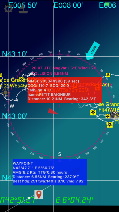
AIS : AtoN, MOB, ships
-------
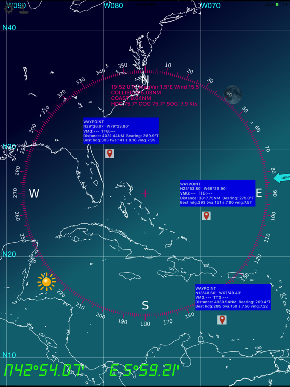
WayPoints
-------
Also embedded are the USCG database and NGA database of all marine lights around the world, that have a nominal range of 10 or more Nautical Miles.
IMPORTANTE NOTICE : Mariners should consult all sources of information they have before engaging their vessel to an unkwnow area, in particular notices to mariners.
NOTICE : NGA and USCG lights databases have been extracted in Feb 2013. This application will be updated in a regular basis.
-------
All major ligthhouses (landing) that have a distance at least 15 NM for the following countries :
Full world coverage.
--------
- based on the NOAA's GSHHS Shoreline Database Version 2.2.0
- world coverage from 75°S to 75°N (poles excluded)
- zoom in and zoom out : automatically selects between the 5 GSHHS databases : full, high, intermediate, low, crude
- mercator projection
- Precise positioning of your boat and other vessels (NMEA GPS and AIS frames)
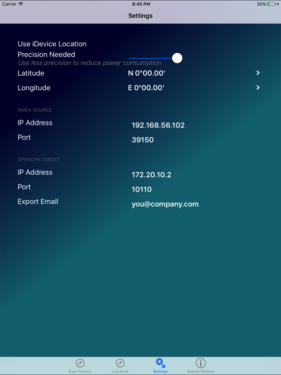
- you need a NMEA Wifi connection (TCP or UDP) with a NMEA repeater like Digital Yacht's iAIS
- log book (date,time,latitude,longitude,COG,SOG,Heading,Log,Water Depth,
TWA,TWS,Leeway,Stream Set, Stream Drift and your comments
- log book organized in passages
- log book export via email (csv format)
- NMEA protocol debug window
- magnetic variation computed with the algorithms from the NOAA's World Magnetic Model
- distance to coast
- distance to others vessels
- 'goto boat' function
- double tap for full screen display
- integrated solar compass : the rose displays the sun and moon positions in real time
Note : AIS display requires an AIS/Wifi gateway
-------
AIS : AtoN, MOB, ships
-------
WayPoints
-------
Also embedded are the USCG database and NGA database of all marine lights around the world, that have a nominal range of 10 or more Nautical Miles.
IMPORTANTE NOTICE : Mariners should consult all sources of information they have before engaging their vessel to an unkwnow area, in particular notices to mariners.
NOTICE : NGA and USCG lights databases have been extracted in Feb 2013. This application will be updated in a regular basis.
-------
All major ligthhouses (landing) that have a distance at least 15 NM for the following countries :
Full world coverage.
--------
- based on the NOAA's GSHHS Shoreline Database Version 2.2.0
- world coverage from 75°S to 75°N (poles excluded)
- zoom in and zoom out : automatically selects between the 5 GSHHS databases : full, high, intermediate, low, crude
- mercator projection
- Precise positioning of your boat and other vessels (NMEA GPS and AIS frames)
- you need a NMEA Wifi connection (TCP or UDP) with a NMEA repeater like Digital Yacht's iAIS
- log book (date,time,latitude,longitude,COG,SOG,Heading,Log,Water Depth,
TWA,TWS,Leeway,Stream Set, Stream Drift and your comments
- log book organized in passages
- log book export via email (csv format)
- NMEA protocol debug window
- magnetic variation computed with the algorithms from the NOAA's World Magnetic Model
- distance to coast
- distance to others vessels
- 'goto boat' function
- double tap for full screen display
- integrated solar compass : the rose displays the sun and moon positions in real time
 このアプリはiPhone、iPadの両方に対応しています。
カテゴリー
ナビゲーション
ナビゲーション
リリース
2012/4/30
2012/4/30
更新
2021/7/21
2021/7/21
バージョン
4.1
4.1
言語
英語
英語
サイズ
295.7 MB
295.7 MB
条件
iPhone 3GS、iPhone 4、iPhone 4S、iPhone 5、iPod touch(第3世代)、iPod touch (第4世代)、iPod touch (第5世代)、およびiPad
iPhone 3GS、iPhone 4、iPhone 4S、iPhone 5、iPod touch(第3世代)、iPod touch (第4世代)、iPod touch (第5世代)、およびiPad
このバージョンの新機能
- fix some display issues when in landscape
- SOG much more visible
- Text in white
- Don't display wind if info is not available
- Udp broadcast support (without ip address)
- fix some display issues when in landscape
- SOG much more visible
- Text in white
- Don't display wind if info is not available
- Udp broadcast support (without ip address)
スクリーンショット - iPhone | iPad
スクリーンショット - iPhone | iPad
DFR Editions の他のアプリ » もっと見る
» 目的別iPhoneアプリ検索
- 辞書 » 日本語対応の辞書 » 英和辞典
- 学習 » 英単語 » 英会話 » クイズで楽しく
- スケジュール » 管理 » Googleカレンダー


Yahoo!乗換案内
Yahoo Japan Corp.無料
Google マップ - ナビ、乗換案内
Google LLC無料
Yahoo!カーナビ
Yahoo Japan Corp.無料
乗換NAVITIME(乗換ナビタイム) - 運行情報や路線図..
NAVITIME JAPAN CO.,LTD.無料
Yahoo! MAP-ヤフーマップ
Yahoo Japan Corp.無料
乗換案内
Jorudan Co.,Ltd.無料
賃貸物件検索 SUUMO(スーモ)でお部屋探し
Recruit Co.,Ltd.無料
NAVITIME(乗換と地図の総合ナビ)
NAVITIME JAPAN CO.,LTD.無料
NAVITIMEドライブサポーター - カーナビ&渋滞情報&..
NAVITIME JAPAN CO.,LTD.無料
お部屋探しはライフルホームズ賃貸・マンション・不動産物件検索
LIFULL Co., Ltd無料


CatchApp新着アプリレビュー
 日本縦断てつどうの旅」")
様々な楽しみ方で運転士として成長していく鉄道運転士育成RPG「プラチナ・トレイン(プラトレ) 日本縦断てつどうの旅」
2016-05-17 00:00

日本語にはない英語発音のリスニングを楽しく学べる「発音どっち?英語リスニング 」
2014-12-20 12:00

指先の瞬発力が試されるカジュアルゲーム「早撃ちパニック」をリリース!
2014-12-08 15:21
新着アプリ動画
-
 ¥1500
¥1500
-
 ¥600
¥600
-
 ¥3000
¥3000