


このアプリのYoutube動画がある場合はURLを送信してください。詳細 »
APPLICATION INFO - iPhoneアプリの詳細情報
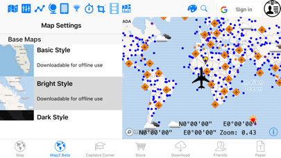
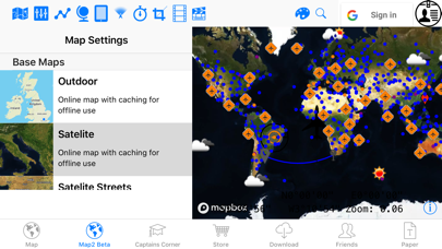
The Pilots Atlas App is an all-in-one map source, also useable offline. It includes topographical maps of the entire world scalable down to 1:1,6 Mio (SD-maps) and 1: 0,795 Mio (HD-maps). You can download one or both maps and in case you don´t need the HD-area, you can delete only the HD-part, the SD-maps will stay on the iPad. Of course thousands of cities, highways, rivers, boundaries, lakes, railways and ferry-routes are included. You can download either one or up to all 6 continents. Create your own map style by switching on/off the 17 different map layers and 21 different databases (aeronautical/ navigation-aids and Points of Interest´s etc.). Insert, store and/ or edit your flight planed route by using ICAO/ IATA-codes, waypoints, VOR´s NDB´s or Lat/ Long. Find positions with a separate Lat/ Long finder. The first 4 zoom levels are for free, for using all options please purchase one area.
Also includes:
- Trip planning (by Waypoints, VOR´s, airports, NDB´s, ICAO/ IATA codes or Lat/ Long).
- Share, copy, invert or export your trip, delete/ edit single trip-points or whole trips. The whole trip-length is shown and also the distance between single trip-points.
- Show all your trips (or select your specials) in the map by different colors.
- 5 different charts on board: planning chart, offline map and online maps (OSM), MapQuest and MapQuest Open Aerial
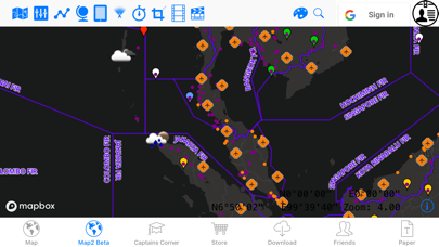
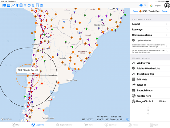
- Airports, waypoints, VOR´s, NDB´s, TACAN, ILS, DME and so on are color coded and you are able to switch on/off the "name/ freq.-labels". Also you can click the icon to get further information (Runway length, elevation, ICAO/ IATA, airport-name, city-name, Lat/ Long, frequencies, variation and much more).
- On each annotation (airport, waypoint, nav-aid, poi or favorite) you can adjust 2 different circles (e.g. one "range-circle" and one "ETOPS-circle".
Weather (METAR + TAF) is available by clicking on the airport-icon and you can create/edit your own weather-list (along your trip/route).
More than 10,000 points of interest. Bridge, building, glacier Lake, National park, mountain/peak, protected area, stadium, deep/sea/trench and volcano.
GPS-tracker position included. You are able to connect an external GPS-receiver with Bluetooth - the GPS-data which your iPad receives will be shown in our "GPS-Tracker-layer".
- Insert your favourites, photos or notes directly on the map
- Contour level by color (meter + feet).
- Email screenshots to friends
- Time alert
- FIR Boundaries including FIR name
- SUA areas (special use airspace)
- You can set the map-scale in: Km, nautical miles (nm), statue miles (sm) or feet (ft)
- You can scan all included aeronautical data by using the search option
- Captains Corner:
- Weather symbols
- Turbulence, VOLMET table
- SNOWTAM decoder (Notam + Metar)
- MEATAR decoder
- Aircraft country table (Capital city, reg.-code, ISO-code, dialing-prefix, time zone)
- ICAO prefix table
- Thumb rules
- Volcano warning
- Aeronautical abbreviations
- Morse codes
- Airport category
- Operating minima
- Operating minima CAT I + II
- Climbrate and Kerosin calculator
- Airport, Nav-aid, Waypoint, POI directory
- TAF decoder
- IATA delay codes
- Dangerous goods
- Military Interception signaling
- Military MEATAR color codes
- Aviation Converter: (temp., mass, area, volume, energy, speed power, pressure, length, force..)
You can download single continents or the whole world and in case of a world-download you are able to delete or re-download the areas you need whenever you like.
Additional weather-overlay as an in-App-subscription: 1-month free trial. Length of subscription: one year. Payment: once a year, charged to iTunes-account. Automatically renews unless auto-renew is turned off at least 24-h before end of period (account settings).
The Weather-Layer is an yearly autorenewing InApp-Subscription-Purchase for 3.99 USD with 30 days free trial.
Continued use of GPS running in the background can dramatically decrease battery life.
Also includes:
- Trip planning (by Waypoints, VOR´s, airports, NDB´s, ICAO/ IATA codes or Lat/ Long).
- Share, copy, invert or export your trip, delete/ edit single trip-points or whole trips. The whole trip-length is shown and also the distance between single trip-points.
- Show all your trips (or select your specials) in the map by different colors.
- 5 different charts on board: planning chart, offline map and online maps (OSM), MapQuest and MapQuest Open Aerial
- Airports, waypoints, VOR´s, NDB´s, TACAN, ILS, DME and so on are color coded and you are able to switch on/off the "name/ freq.-labels". Also you can click the icon to get further information (Runway length, elevation, ICAO/ IATA, airport-name, city-name, Lat/ Long, frequencies, variation and much more).
- On each annotation (airport, waypoint, nav-aid, poi or favorite) you can adjust 2 different circles (e.g. one "range-circle" and one "ETOPS-circle".
Weather (METAR + TAF) is available by clicking on the airport-icon and you can create/edit your own weather-list (along your trip/route).
More than 10,000 points of interest. Bridge, building, glacier Lake, National park, mountain/peak, protected area, stadium, deep/sea/trench and volcano.
GPS-tracker position included. You are able to connect an external GPS-receiver with Bluetooth - the GPS-data which your iPad receives will be shown in our "GPS-Tracker-layer".
- Insert your favourites, photos or notes directly on the map
- Contour level by color (meter + feet).
- Email screenshots to friends
- Time alert
- FIR Boundaries including FIR name
- SUA areas (special use airspace)
- You can set the map-scale in: Km, nautical miles (nm), statue miles (sm) or feet (ft)
- You can scan all included aeronautical data by using the search option
- Captains Corner:
- Weather symbols
- Turbulence, VOLMET table
- SNOWTAM decoder (Notam + Metar)
- MEATAR decoder
- Aircraft country table (Capital city, reg.-code, ISO-code, dialing-prefix, time zone)
- ICAO prefix table
- Thumb rules
- Volcano warning
- Aeronautical abbreviations
- Morse codes
- Airport category
- Operating minima
- Operating minima CAT I + II
- Climbrate and Kerosin calculator
- Airport, Nav-aid, Waypoint, POI directory
- TAF decoder
- IATA delay codes
- Dangerous goods
- Military Interception signaling
- Military MEATAR color codes
- Aviation Converter: (temp., mass, area, volume, energy, speed power, pressure, length, force..)
You can download single continents or the whole world and in case of a world-download you are able to delete or re-download the areas you need whenever you like.
Additional weather-overlay as an in-App-subscription: 1-month free trial. Length of subscription: one year. Payment: once a year, charged to iTunes-account. Automatically renews unless auto-renew is turned off at least 24-h before end of period (account settings).
The Weather-Layer is an yearly autorenewing InApp-Subscription-Purchase for 3.99 USD with 30 days free trial.
Continued use of GPS running in the background can dramatically decrease battery life.
※iPadでご利用できるアプリです。
カテゴリー
旅行
旅行
リリース
2013/7/23
2013/7/23
更新
2016/6/5
2016/6/5
バージョン
2.8.2
2.8.2
言語
サイズ
409 MB
409 MB
条件
このバージョンの新機能
Fix for NASA-Maps.
Fix for NASA-Maps.
スクリーンショット - iPhone | iPad
スクリーンショット - iPhone | iPad
» 目的別iPhoneアプリ検索
- 辞書 » 日本語対応の辞書 » 英和辞典
- 学習 » 英単語 » 英会話 » クイズで楽しく
- スケジュール » 管理 » Googleカレンダー


Google Earth
Google LLC無料
じゃらん
Recruit Co.,Ltd.無料
楽天トラベル
Rakuten Travel Inc.無料
ホテルズドットコム - 国内・海外のホテルをお得に予約
Hotels.com無料
ANA
ANA (All Nippon Airways)無料
アトラクション待ち時間
NORIHIKO HAYASAKA無料
エクスペディア - ホテル予約、格安航空券&現地ツアー予約
Expedia, Inc.無料
まっぷるリンク
Shobunsha Publications, Inc.無料
週刊じゃらん -旬の観光・グルメ・宿情報をまとめ読み
Recruit Co.,Ltd.無料
ホテル予約 厳選20社 旅比較ねっと
BIGLOBE Inc.無料


CatchApp新着アプリレビュー
 日本縦断てつどうの旅」")
様々な楽しみ方で運転士として成長していく鉄道運転士育成RPG「プラチナ・トレイン(プラトレ) 日本縦断てつどうの旅」
2016-05-17 00:00

日本語にはない英語発音のリスニングを楽しく学べる「発音どっち?英語リスニング 」
2014-12-20 12:00

指先の瞬発力が試されるカジュアルゲーム「早撃ちパニック」をリリース!
2014-12-08 15:21
新着アプリ動画
-
 ¥1500
¥1500
-
 ¥600
¥600
-
 ¥3000
¥3000