


このアプリのYoutube動画がある場合はURLを送信してください。詳細 »
APPLICATION INFO - iPhoneアプリの詳細情報
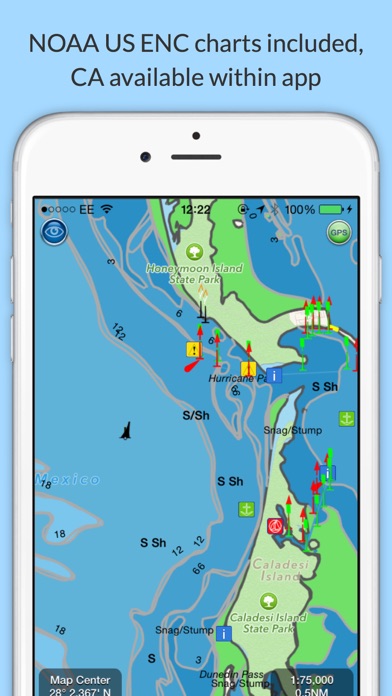
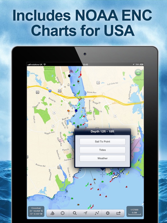
Explore, Plan and Navigate your boating trips in real time and outstanding high-resolution with the latest NOAA Marine charts covering the whole of the USA and US Great Lakes.
- Includes all US Coastal, Inland and Great Lakes Digital Vector Charts
- Buoys, lights etc. are tappable with bearing and distance
- Free Apple Watch app
- Seamless panning and zooming across charts
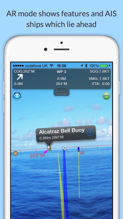
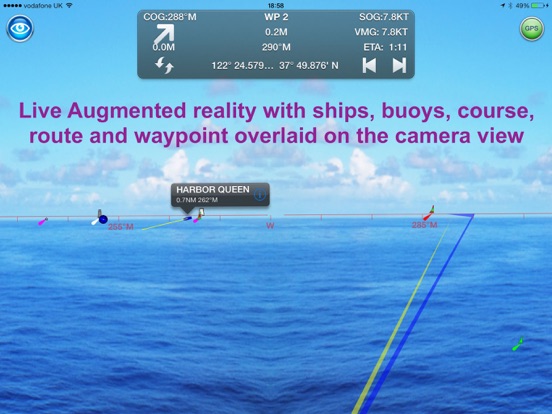
- Unique live Augmented Reality camera view
- Route Planning and tracking with Waypoints, ETA, XTE, etc.
- Offline charts
- Route export and import
- Live AIS Ship targets (requires Boat Beacon)
- ActiveCaptain Marinas, Anchorage, Hazards and reviews
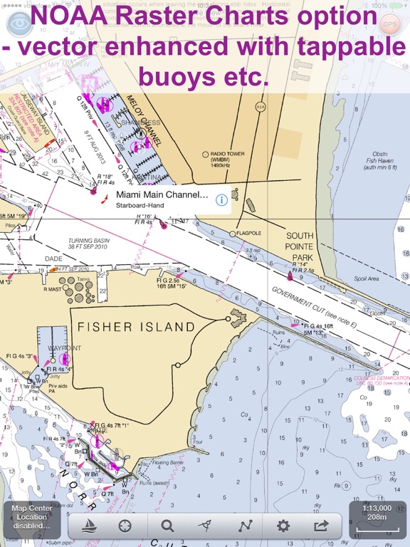
- US NOAA Raster charts available via IAP
- Canadian charts via IAP
- External NMEA over Wifi
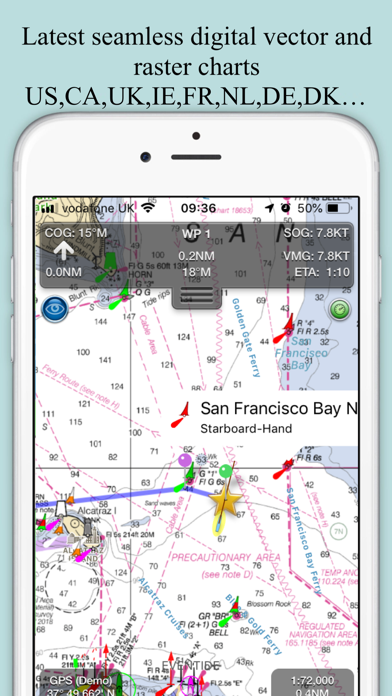
SeaNav is a Universal app, which works on iPad, iPhone and iPod.
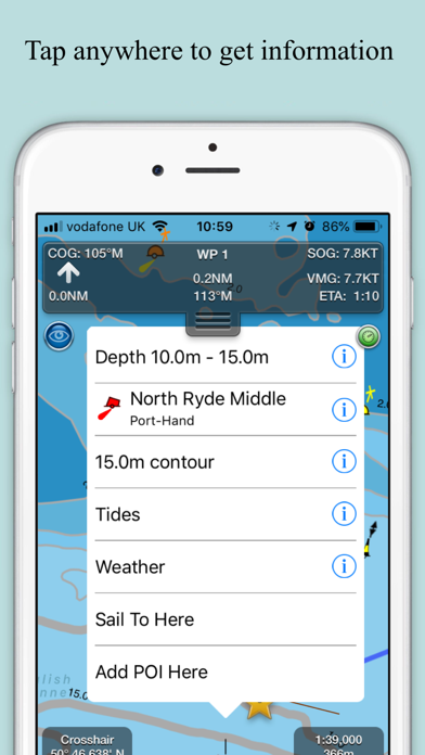
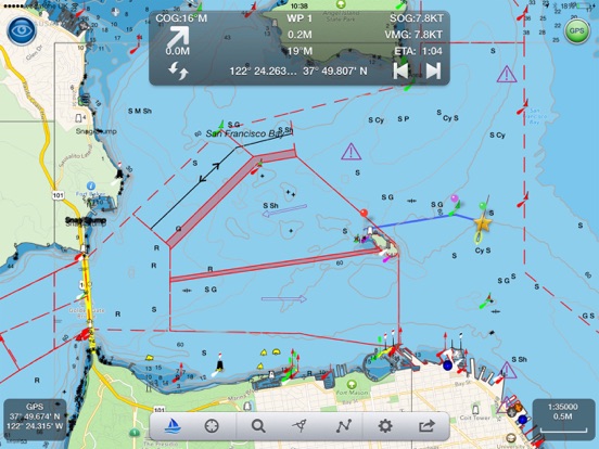
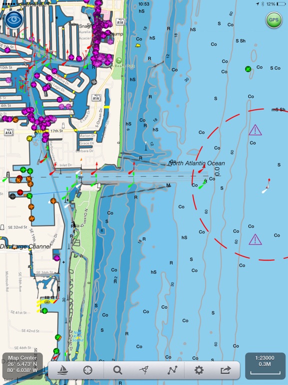
SeaNav uses Digital Vector charts providing a wealth of benefits and advantages. Buoys, Lights, Bridges, Depth Contours, Depth Soundings, Rocks, Anchorage areas, NOAA Weather Buoys etc. are all selectable and have real time distance, bearing and detail information. Turn off layers to de-clutter the display and only show what is important at the time. Tides, moon and sun times and weather are also all available at your fingertips.
SeaNav’s unique AR view mode allows you to view buoys, lights, ships, waypoints and track overlaid on your iPhone or iPad live camera view. With "AR LockOn" you can select a target on the chart and then be guided to it in the AR camera view.
SeaNav lets you measure distances and bearings and record waypoints on routes. When at sea, the app’s Sailing HUD shows your position, Course over ground (COG), Speed over ground (SOG), Vector Made Good (VMG), Estimated Time of Arrival (ETA), Distance and bearing to next Waypoint. Waypoint reached alerts, auto-routing to the next waypoint and collision alerts.
SeaNav has free Apple Watch and Pebble Smartwatch apps available.
Lowrance, Simrad and B&G GoFree support included.
Your purchase of SeaNav includes 12 months of free updates to the included US chart set. Further chart updates are then available via an in-app purchase. Charts for other regions including Canada may also be added to your product via optional in-app purchase.
Our in-app purchases are 1 year subscriptions, which automatically renew at the end of the subscription period unless auto-renew is turned off at least 24-hours before the end of the current period. Payment will be charged to your iTunes Account at confirmation of purchase, and will be charged for renewal within 24-hours prior to the end of the current period. Pricing for our 1 year US Charts update subscription is US$9.99.
Subscriptions may be managed by the iTunes account holder and auto-renewal may be turned off by going to Account Settings after purchase.
No cancellation of the current subscription is allowed during active subscription period.
Our Privacy Policy may be accessed via http://seanav.net/privacy.php
Requires iPhone or iPad. GPS only required for real time route navigation. Optional Real time AIS, Tides and Weather information require an active internet connection.
Real-time route navigation requires a GPS location. iPhone devices and iPads with a cellular modem already have a built-in GPS, even if they do not have an active service plan.
If you have a WiFi-only iPad or iPod you will need an external GPS receiver to enable navigation. Inexpensive 3rd Party units are available to add these accurate location capabilities to your device via bluetooth.
Please note that continued use of GPS running in the background can dramatically decrease battery life.
NOT FOR NAVIGATION
This program is distributed in the hope that it will be useful. SeaNav should only be used for basic navigation reference and should not be solely relied upon to determine precise locations, proximity, distance, or direction.
Third Party Licenses and Notices
NOTICE: US Marine Charts are derived from official NOAA Electronic Navigational Charts.
- Includes all US Coastal, Inland and Great Lakes Digital Vector Charts
- Buoys, lights etc. are tappable with bearing and distance
- Free Apple Watch app
- Seamless panning and zooming across charts
- Unique live Augmented Reality camera view
- Route Planning and tracking with Waypoints, ETA, XTE, etc.
- Offline charts
- Route export and import
- Live AIS Ship targets (requires Boat Beacon)
- ActiveCaptain Marinas, Anchorage, Hazards and reviews
- US NOAA Raster charts available via IAP
- Canadian charts via IAP
- External NMEA over Wifi
SeaNav is a Universal app, which works on iPad, iPhone and iPod.
SeaNav uses Digital Vector charts providing a wealth of benefits and advantages. Buoys, Lights, Bridges, Depth Contours, Depth Soundings, Rocks, Anchorage areas, NOAA Weather Buoys etc. are all selectable and have real time distance, bearing and detail information. Turn off layers to de-clutter the display and only show what is important at the time. Tides, moon and sun times and weather are also all available at your fingertips.
SeaNav’s unique AR view mode allows you to view buoys, lights, ships, waypoints and track overlaid on your iPhone or iPad live camera view. With "AR LockOn" you can select a target on the chart and then be guided to it in the AR camera view.
SeaNav lets you measure distances and bearings and record waypoints on routes. When at sea, the app’s Sailing HUD shows your position, Course over ground (COG), Speed over ground (SOG), Vector Made Good (VMG), Estimated Time of Arrival (ETA), Distance and bearing to next Waypoint. Waypoint reached alerts, auto-routing to the next waypoint and collision alerts.
SeaNav has free Apple Watch and Pebble Smartwatch apps available.
Lowrance, Simrad and B&G GoFree support included.
Your purchase of SeaNav includes 12 months of free updates to the included US chart set. Further chart updates are then available via an in-app purchase. Charts for other regions including Canada may also be added to your product via optional in-app purchase.
Our in-app purchases are 1 year subscriptions, which automatically renew at the end of the subscription period unless auto-renew is turned off at least 24-hours before the end of the current period. Payment will be charged to your iTunes Account at confirmation of purchase, and will be charged for renewal within 24-hours prior to the end of the current period. Pricing for our 1 year US Charts update subscription is US$9.99.
Subscriptions may be managed by the iTunes account holder and auto-renewal may be turned off by going to Account Settings after purchase.
No cancellation of the current subscription is allowed during active subscription period.
Our Privacy Policy may be accessed via http://seanav.net/privacy.php
Requires iPhone or iPad. GPS only required for real time route navigation. Optional Real time AIS, Tides and Weather information require an active internet connection.
Real-time route navigation requires a GPS location. iPhone devices and iPads with a cellular modem already have a built-in GPS, even if they do not have an active service plan.
If you have a WiFi-only iPad or iPod you will need an external GPS receiver to enable navigation. Inexpensive 3rd Party units are available to add these accurate location capabilities to your device via bluetooth.
Please note that continued use of GPS running in the background can dramatically decrease battery life.
NOT FOR NAVIGATION
This program is distributed in the hope that it will be useful. SeaNav should only be used for basic navigation reference and should not be solely relied upon to determine precise locations, proximity, distance, or direction.
Third Party Licenses and Notices
NOTICE: US Marine Charts are derived from official NOAA Electronic Navigational Charts.
 このアプリはiPhone、iPadの両方に対応しています。
カテゴリー
ナビゲーション
ナビゲーション
リリース
2013/4/18
2013/4/18
更新
2021/6/16
2021/6/16
バージョン
5.3.3
5.3.3
言語
英語
英語
サイズ
45.9 MB
45.9 MB
条件
iPhone 3GS、iPhone 4、iPhone 4S、iPhone 5 および iPad 互換 iOS 6.0 以降が必要 iPhone 5 用に最適化済み
iPhone 3GS、iPhone 4、iPhone 4S、iPhone 5 および iPad 互換 iOS 6.0 以降が必要 iPhone 5 用に最適化済み
このバージョンの新機能
Much faster chart drawing on newer Apple devices ( iPhone 9 and later and iPad 6th gen and later)
Support for iOS Dark mode - better for night time vision and use.
SeaNav iOS and its charts now works on the new MacBook M1.
Cardinal mark light patterns
Much faster chart drawing on newer Apple devices ( iPhone 9 and later and iPad 6th gen and later)
Support for iOS Dark mode - better for night time vision and use.
SeaNav iOS and its charts now works on the new MacBook M1.
Cardinal mark light patterns
スクリーンショット - iPhone | iPad
スクリーンショット - iPhone | iPad
Pocket Mariner Ltd. の他のアプリ » もっと見る
» 目的別iPhoneアプリ検索
- 辞書 » 日本語対応の辞書 » 英和辞典
- 学習 » 英単語 » 英会話 » クイズで楽しく
- スケジュール » 管理 » Googleカレンダー


Yahoo!乗換案内
Yahoo Japan Corp.無料
Google マップ - ナビ、乗換案内
Google LLC無料
Yahoo!カーナビ
Yahoo Japan Corp.無料
乗換NAVITIME(乗換ナビタイム) - 運行情報や路線図..
NAVITIME JAPAN CO.,LTD.無料
Yahoo! MAP-ヤフーマップ
Yahoo Japan Corp.無料
乗換案内
Jorudan Co.,Ltd.無料
賃貸物件検索 SUUMO(スーモ)でお部屋探し
Recruit Co.,Ltd.無料
NAVITIME(乗換と地図の総合ナビ)
NAVITIME JAPAN CO.,LTD.無料
NAVITIMEドライブサポーター - カーナビ&渋滞情報&..
NAVITIME JAPAN CO.,LTD.無料
お部屋探しはライフルホームズ賃貸・マンション・不動産物件検索
LIFULL Co., Ltd無料


CatchApp新着アプリレビュー
 日本縦断てつどうの旅」")
様々な楽しみ方で運転士として成長していく鉄道運転士育成RPG「プラチナ・トレイン(プラトレ) 日本縦断てつどうの旅」
2016-05-17 00:00

日本語にはない英語発音のリスニングを楽しく学べる「発音どっち?英語リスニング 」
2014-12-20 12:00

指先の瞬発力が試されるカジュアルゲーム「早撃ちパニック」をリリース!
2014-12-08 15:21
新着アプリ動画
-
 ¥1500
¥1500
-
 ¥600
¥600
-
 ¥3000
¥3000