


このアプリのYoutube動画がある場合はURLを送信してください。詳細 »
APPLICATION INFO - iPhoneアプリの詳細情報
Welcome to Map Map – Your Personal Cartographer!
Ever wished you could see where you were on a trail map, building diagram, or any other visual reference? How about knowing where a trail drops you off? Look no further! MapMap empowers you to create personalized MapMaps by overlaying your photos on Apple's dynamic maps, providing you with a unique and immersive navigation experience.
Capture and Import:
Take a photo of any map or import one from your photo library, the files app, or even heck even drag and drop it right in. Whether it's a hiking trail, a historical site, or a complex building layout, MapMap transforms your visuals into interactive maps.
Alignment Magic:
Did you snap a photo at a slight angle? No worries! MapMap's alignment feature lets you straighten and align your images effortlessly, ensuring accurate overlays every time.
MapMap Flexibility:
Map Maps rotate and scale with Apple Maps, ensuring a smooth and dynamic experience. Customize your maps to suit your preferences and explore your surroundings like never before.
Can't Bring Your Own Map?
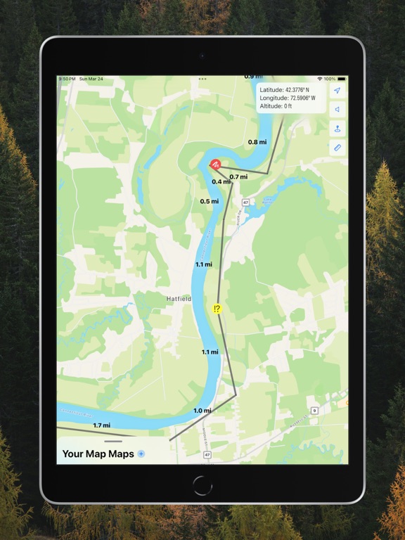
Need to get maps where nobody has gone before? Through the magic of GPS, you can create your own maps, and color-code segments as if it were the trail itself! You even get a Live Activity to see some stats about your journey.
Customizable Markers:
Enhance your MapMap with personalized markers! Choose from a variety of colors and symbols to mark points of interest, landmarks, or your favorite spots. You have the option to decide whether markers rotate with the map or stay fixed – tailor your experience to match your needs.
Distance Measuring:
Don’t know how long something like a trail is? Measure it with a tap and a drag! All measurements are latitude corrected, so you can make sure that your outdoor adventures are just right. And through the power of snapping, everything can be lined up nicely.
Marked up MapMaps:
Need to follow the "Red Trail" but keep losing where it goes on the map? Highlight the trail in red to have it stand out! Not sure where all the break rooms are in your building? Highlight them in green and put a big arrow on it to keep track of all the coffee makers.
Voice Alerts:
Are you flying down a trail, or even just walking, and OH you missed a left? Turn on voice alerts and get a heads up when that turn is coming. Drop a marker down on the spot, and MapMap will let you know when you're getting close.
Maps Integration:
Find a great spot, but don't know how to get there? MapMap integrates with the Maps app, so you can open the exact spot with a pin with just a long-press on a marker or the compass!
Real-Time Location Tracking:
See your current location seamlessly integrated into your MapMap in real-time. Navigate with ease as your position is displayed over your customized maps, providing a whole new perspective to your surroundings.
Your Position, Your Way:
Want to talk about your position, but hate reading out "44.4731º North, 73.2057º West? Swap those over to degrees, minutes, and seconds for smaller numbers in the compass!
Endless Possibilities:
MapMap is perfect for outdoor adventures, urban explorations, or simply navigating complex spaces. Create MapMaps for hiking, biking, exploring new cities, or mastering the layout of a building – the possibilities are as diverse as your interests.
Key Features:
Overlay photos on Apple Maps that rotate and scale.
Mark your path with GPS tracking, and tagging.
Effortless alignment for accurate overlays.
Customizable markers with various colors and symbols.
Measure distances freely and with snap and drag.
Markup your MapMaps for improved visibility.
Optional audio alerts when you're getting near a marker.
Integration with your Maps app.
Discover the world in a whole new way with MapMap – where your photos become personalized maps. Download now and embark on your next adventure with confidence!
Ever wished you could see where you were on a trail map, building diagram, or any other visual reference? How about knowing where a trail drops you off? Look no further! MapMap empowers you to create personalized MapMaps by overlaying your photos on Apple's dynamic maps, providing you with a unique and immersive navigation experience.
Capture and Import:
Take a photo of any map or import one from your photo library, the files app, or even heck even drag and drop it right in. Whether it's a hiking trail, a historical site, or a complex building layout, MapMap transforms your visuals into interactive maps.
Alignment Magic:
Did you snap a photo at a slight angle? No worries! MapMap's alignment feature lets you straighten and align your images effortlessly, ensuring accurate overlays every time.
MapMap Flexibility:
Map Maps rotate and scale with Apple Maps, ensuring a smooth and dynamic experience. Customize your maps to suit your preferences and explore your surroundings like never before.
Can't Bring Your Own Map?
Need to get maps where nobody has gone before? Through the magic of GPS, you can create your own maps, and color-code segments as if it were the trail itself! You even get a Live Activity to see some stats about your journey.
Customizable Markers:
Enhance your MapMap with personalized markers! Choose from a variety of colors and symbols to mark points of interest, landmarks, or your favorite spots. You have the option to decide whether markers rotate with the map or stay fixed – tailor your experience to match your needs.
Distance Measuring:
Don’t know how long something like a trail is? Measure it with a tap and a drag! All measurements are latitude corrected, so you can make sure that your outdoor adventures are just right. And through the power of snapping, everything can be lined up nicely.
Marked up MapMaps:
Need to follow the "Red Trail" but keep losing where it goes on the map? Highlight the trail in red to have it stand out! Not sure where all the break rooms are in your building? Highlight them in green and put a big arrow on it to keep track of all the coffee makers.
Voice Alerts:
Are you flying down a trail, or even just walking, and OH you missed a left? Turn on voice alerts and get a heads up when that turn is coming. Drop a marker down on the spot, and MapMap will let you know when you're getting close.
Maps Integration:
Find a great spot, but don't know how to get there? MapMap integrates with the Maps app, so you can open the exact spot with a pin with just a long-press on a marker or the compass!
Real-Time Location Tracking:
See your current location seamlessly integrated into your MapMap in real-time. Navigate with ease as your position is displayed over your customized maps, providing a whole new perspective to your surroundings.
Your Position, Your Way:
Want to talk about your position, but hate reading out "44.4731º North, 73.2057º West? Swap those over to degrees, minutes, and seconds for smaller numbers in the compass!
Endless Possibilities:
MapMap is perfect for outdoor adventures, urban explorations, or simply navigating complex spaces. Create MapMaps for hiking, biking, exploring new cities, or mastering the layout of a building – the possibilities are as diverse as your interests.
Key Features:
Overlay photos on Apple Maps that rotate and scale.
Mark your path with GPS tracking, and tagging.
Effortless alignment for accurate overlays.
Customizable markers with various colors and symbols.
Measure distances freely and with snap and drag.
Markup your MapMaps for improved visibility.
Optional audio alerts when you're getting near a marker.
Integration with your Maps app.
Discover the world in a whole new way with MapMap – where your photos become personalized maps. Download now and embark on your next adventure with confidence!
 このアプリはiPhone、iPadの両方に対応しています。
カテゴリー
ナビゲーション
ナビゲーション
リリース
2024/4/2
2024/4/2
更新
2024/4/10
2024/4/10
バージョン
2.2.1
2.2.1
言語
サイズ
2.9 MB
2.9 MB
条件
このバージョンの新機能
Fixes:
- Distances over 100m displayed "km" label without converting to kilometers
Thanks u/Photograph-Silver for catching it!
Fixes:
- Distances over 100m displayed "km" label without converting to kilometers
Thanks u/Photograph-Silver for catching it!
スクリーンショット - iPhone | iPad
スクリーンショット - iPhone | iPad
» 目的別iPhoneアプリ検索
- 辞書 » 日本語対応の辞書 » 英和辞典
- 学習 » 英単語 » 英会話 » クイズで楽しく
- スケジュール » 管理 » Googleカレンダー


Yahoo!乗換案内
Yahoo Japan Corp.無料
Google マップ - ナビ、乗換案内
Google LLC無料
Yahoo!カーナビ
Yahoo Japan Corp.無料
乗換NAVITIME(乗換ナビタイム) - 運行情報や路線図..
NAVITIME JAPAN CO.,LTD.無料
Yahoo! MAP-ヤフーマップ
Yahoo Japan Corp.無料
乗換案内
Jorudan Co.,Ltd.無料
賃貸物件検索 SUUMO(スーモ)でお部屋探し
Recruit Co.,Ltd.無料
NAVITIME(乗換と地図の総合ナビ)
NAVITIME JAPAN CO.,LTD.無料
NAVITIMEドライブサポーター - カーナビ&渋滞情報&..
NAVITIME JAPAN CO.,LTD.無料
お部屋探しはライフルホームズ賃貸・マンション・不動産物件検索
LIFULL Co., Ltd無料


CatchApp新着アプリレビュー
 日本縦断てつどうの旅」")
様々な楽しみ方で運転士として成長していく鉄道運転士育成RPG「プラチナ・トレイン(プラトレ) 日本縦断てつどうの旅」
2016-05-17 00:00

日本語にはない英語発音のリスニングを楽しく学べる「発音どっち?英語リスニング 」
2014-12-20 12:00

指先の瞬発力が試されるカジュアルゲーム「早撃ちパニック」をリリース!
2014-12-08 15:21
新着アプリ動画
-
 ¥1500
¥1500
-
 ¥600
¥600
-
 ¥3000
¥3000