


このアプリのYoutube動画がある場合はURLを送信してください。詳細 »
APPLICATION INFO - iPhoneアプリの詳細情報
World’s Most Popular Marine & Lakes App! A favorite among cruisers, sailors, fishermen and divers. Find the same detailed charts as on the best GPS plotters. Download the app, then go to Menu>Charts and select your region to get two weeks free trial to the overwhelming value of Navionics+.
Navionics+ includes:
√ Download of the following chart layers that will reside on your device even after expiration:
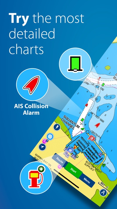
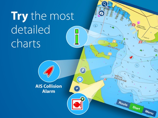
-NAUTICAL CHART for all essential cartographic reference detail. The most accurate and thorough set of information based on Hydrographic Office data, Notices to Mariners, new publications, our own surveys, and reports from users. It provides port plans, safety depth contours, marine services info, tides & currents, navigation aids and more.
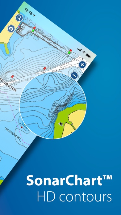
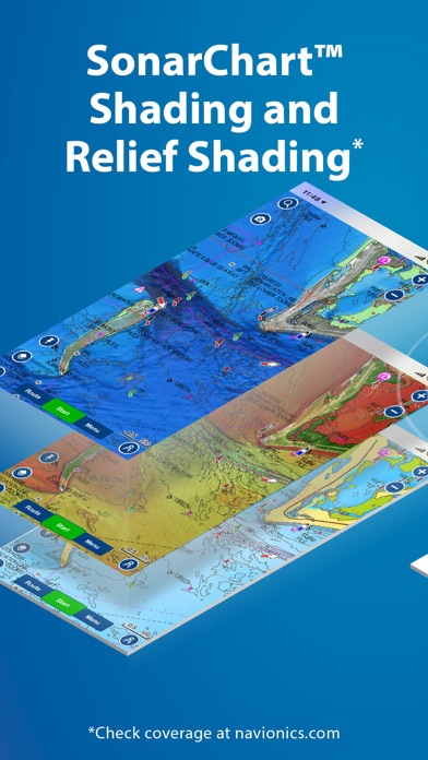
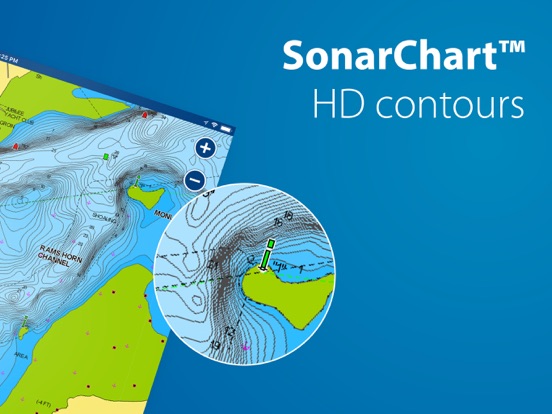
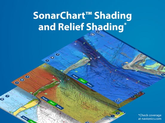
-SONARCHART™ the award-winning 1 ft/ 0,5 m HD bathymetry map that reflects ever-changing conditions. Be part of the community and contribute by uploading your sonar logs to enhance it.
- COMMUNITY EDITS made by users (rocks, wrecks, etc.) and shared for all to benefit.
√ CHART UPDATES: we deliver more than 2,000 updates every day! Take advantage of our updates as frequently as you like.
√ ADVANCED MAP OPTIONS to highlight Shallow Areas, select Depth Shading, filter Depth Contours, and adjust shorelines to selected Water Level. Includes a Fishing Mode.
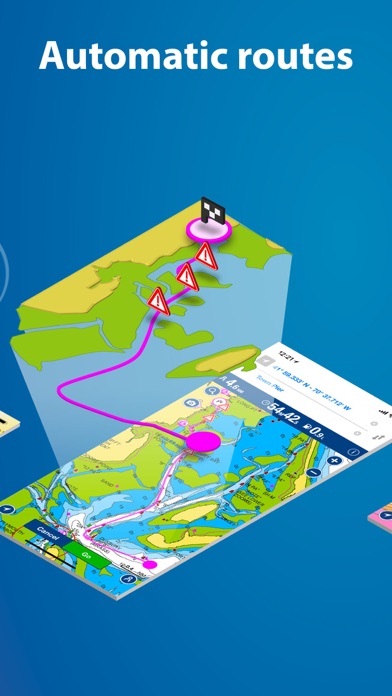
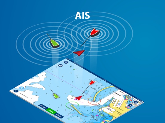
√ NAVIGATION MODULE for advanced route planning with ETA, distance to arrival, heading to WP, fuel consumption and more!
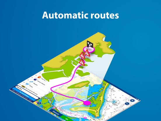
√ DOCK-TO-DOCK AUTOROUTING quickly creates detailed routes even through narrow waterways and channels, based on chart data and navigation aids. POIs are automatically shown nearby your destination.
√ WEATHER & TIDES provides real-time weather data and forecasts. Access daily and hourly forecasts for your favorite locations and get wind, weather buoys, Tides & Currents overlaid on your map. Buoy data is retrieved from NOAA and can include wind speed, gust and direction as well as air pressure, water temperature, wave height and other relevant marine data.
Note: Download detailed maps by zooming in or from Menu>Download Map. Check navionics.com for coverage.
Navionics+ is a one year subscription. At expiration you can renew with a discount of up to 50%. If you don’t renew, you can still use the charts you previously downloaded, along with several free features:
TRACK your journey, view speed, distance, start, stop and total time and COG. Save, see stats and playback.
ROUTES: create and edit, based on speed and fuel consumption.
Measure DISTANCE, add MARKERS, get WIND FORECASTS and sun/moon cycles.
MAP OPTIONS: Satellite/Terrain, Safety Depth and Easy View (not on Govt. Charts).
SYNC Tracks, Routes & Markers among your mobile devices.
MAGAZINES & GUIDES for location-based articles.
GOVT. CHART in US.
SONARCHART™ LIVE allows you to create new personal 1ft/0.5 m HD bathymetry maps that display in real time while navigating. Upload your sonar logs to build even better local charts for your area connecting wirelessly to a compatible sounder/plotter
PLOTTER SYNC - Raymarine Wi-Fi enabled plotter owners can transfer routes and markers, upload sonar logs for improved SonarChart™ and update their eligible plotter card connecting to Navionics through this mobile app.
Updates are available with iOS 7.0 or higher devices. GPS running in the background can dramatically decrease battery life
To enjoy our charts in HD, search our apps for iPad.
Navionics+ includes:
√ Download of the following chart layers that will reside on your device even after expiration:
-NAUTICAL CHART for all essential cartographic reference detail. The most accurate and thorough set of information based on Hydrographic Office data, Notices to Mariners, new publications, our own surveys, and reports from users. It provides port plans, safety depth contours, marine services info, tides & currents, navigation aids and more.
-SONARCHART™ the award-winning 1 ft/ 0,5 m HD bathymetry map that reflects ever-changing conditions. Be part of the community and contribute by uploading your sonar logs to enhance it.
- COMMUNITY EDITS made by users (rocks, wrecks, etc.) and shared for all to benefit.
√ CHART UPDATES: we deliver more than 2,000 updates every day! Take advantage of our updates as frequently as you like.
√ ADVANCED MAP OPTIONS to highlight Shallow Areas, select Depth Shading, filter Depth Contours, and adjust shorelines to selected Water Level. Includes a Fishing Mode.
√ NAVIGATION MODULE for advanced route planning with ETA, distance to arrival, heading to WP, fuel consumption and more!
√ DOCK-TO-DOCK AUTOROUTING quickly creates detailed routes even through narrow waterways and channels, based on chart data and navigation aids. POIs are automatically shown nearby your destination.
√ WEATHER & TIDES provides real-time weather data and forecasts. Access daily and hourly forecasts for your favorite locations and get wind, weather buoys, Tides & Currents overlaid on your map. Buoy data is retrieved from NOAA and can include wind speed, gust and direction as well as air pressure, water temperature, wave height and other relevant marine data.
Note: Download detailed maps by zooming in or from Menu>Download Map. Check navionics.com for coverage.
Navionics+ is a one year subscription. At expiration you can renew with a discount of up to 50%. If you don’t renew, you can still use the charts you previously downloaded, along with several free features:
TRACK your journey, view speed, distance, start, stop and total time and COG. Save, see stats and playback.
ROUTES: create and edit, based on speed and fuel consumption.
Measure DISTANCE, add MARKERS, get WIND FORECASTS and sun/moon cycles.
MAP OPTIONS: Satellite/Terrain, Safety Depth and Easy View (not on Govt. Charts).
SYNC Tracks, Routes & Markers among your mobile devices.
MAGAZINES & GUIDES for location-based articles.
GOVT. CHART in US.
SONARCHART™ LIVE allows you to create new personal 1ft/0.5 m HD bathymetry maps that display in real time while navigating. Upload your sonar logs to build even better local charts for your area connecting wirelessly to a compatible sounder/plotter
PLOTTER SYNC - Raymarine Wi-Fi enabled plotter owners can transfer routes and markers, upload sonar logs for improved SonarChart™ and update their eligible plotter card connecting to Navionics through this mobile app.
Updates are available with iOS 7.0 or higher devices. GPS running in the background can dramatically decrease battery life
To enjoy our charts in HD, search our apps for iPad.
カテゴリー
ナビゲーション
ナビゲーション
リリース
2014/1/2
2014/1/2
更新
2016/7/18
2016/7/18
バージョン
9.0.4
9.0.4
言語
サイズ
89.7 MB
89.7 MB
条件
このバージョンの新機能
· Bug fixing and optimizations
· Bug fixing and optimizations
スクリーンショット - iPhone | iPad
スクリーンショット - iPhone | iPad
» 目的別iPhoneアプリ検索
- 辞書 » 日本語対応の辞書 » 英和辞典
- 学習 » 英単語 » 英会話 » クイズで楽しく
- スケジュール » 管理 » Googleカレンダー


Yahoo!乗換案内
Yahoo Japan Corp.無料
Google マップ - ナビ、乗換案内
Google LLC無料
Yahoo!カーナビ
Yahoo Japan Corp.無料
乗換NAVITIME(乗換ナビタイム) - 運行情報や路線図..
NAVITIME JAPAN CO.,LTD.無料
Yahoo! MAP-ヤフーマップ
Yahoo Japan Corp.無料
乗換案内
Jorudan Co.,Ltd.無料
賃貸物件検索 SUUMO(スーモ)でお部屋探し
Recruit Co.,Ltd.無料
NAVITIME(乗換と地図の総合ナビ)
NAVITIME JAPAN CO.,LTD.無料
NAVITIMEドライブサポーター - カーナビ&渋滞情報&..
NAVITIME JAPAN CO.,LTD.無料
お部屋探しはライフルホームズ賃貸・マンション・不動産物件検索
LIFULL Co., Ltd無料


CatchApp新着アプリレビュー
 日本縦断てつどうの旅」")
様々な楽しみ方で運転士として成長していく鉄道運転士育成RPG「プラチナ・トレイン(プラトレ) 日本縦断てつどうの旅」
2016-05-17 00:00

日本語にはない英語発音のリスニングを楽しく学べる「発音どっち?英語リスニング 」
2014-12-20 12:00

指先の瞬発力が試されるカジュアルゲーム「早撃ちパニック」をリリース!
2014-12-08 15:21
新着アプリ動画
-
 ¥1500
¥1500
-
 ¥600
¥600
-
 ¥3000
¥3000