


このアプリのYoutube動画がある場合はURLを送信してください。詳細 »
APPLICATION INFO - iPhoneアプリの詳細情報
Make the most of your adventures in the great outdoors with OS Locate. Used alongside your Ordnance Survey map, OS Locate is a fast and highly accurate means of pinpointing your exact location on the map, anywhere in Great Britain. If you have lost your bearings or simply would like a little reassurance, OS Locate is the ideal companion for all enthusiasts of the great outdoors.
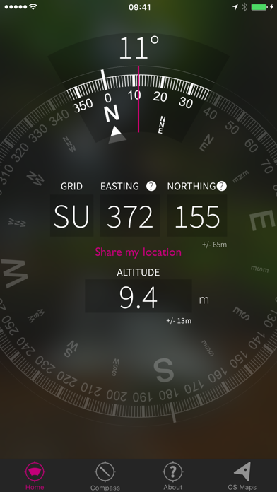
The app converts GPS location readings from your mobile phone to Ordnance Survey National Grid references, enabling you to determine precisely where you are on an Ordnance Survey map. No mobile signal? No problem; OS Locate does not require a mobile signal to function – the inbuilt GPS system can be relied upon, even in the most remote areas.
Simply download the app and switch on your device’s location services (Settings – Privacy – Location services).
OS Locate is packed with additional features. The ‘Share’ button allows you to connect with friends and family via messaging and social media – let them know where you are, how your adventure is progressing and what time you will be home. Use the handy digital compass to take your bearings – always ensuring you are on the right track. For those who are keen to learn more about maps and navigation, the ‘About’ button hosts a wealth of information including hints and tips and a guide to map reading. In addition, you will find simple yet comprehensive guides on how to use eastings and northings.
OS Locate – know where you are.
OS Locate is a complementary tool for Ordnance Survey paper maps. You should always have an Ordnance Survey paper map and baseplate compass when exploring the great outdoors.
Continued use of GPS running in the background can dramatically decrease battery life.
Please ensure your Location Services are turned on.
OS Locate has been updated to provide even greater peace of mind by providing accurate altitude information. As this is taken from the GPS signal, it will always be available.
Also new for version 1.1, OS Locate will automatically detect whether you are outside Great Britain, and convert Ordnance Survey’s Northing and Easting location information into internationally recognised Latitude and Longitude readings, which can be used anywhere in the world.
Finally, Ordnance Survey has partnered with Silva Compasses to update the virtual compass feature to use Silva’s trademarked design for greater usability.
カテゴリー
ナビゲーション
ナビゲーション
リリース
2014/2/12
2014/2/12
更新
2016/7/1
2016/7/1
バージョン
1.3
1.3
言語
サイズ
13.8 MB
13.8 MB
条件
このバージョンの新機能
• Shared location links now open in OS Maps
• All heights and distances now respect feet/metres preference
• New compass design
• Shared location links now open in OS Maps
• All heights and distances now respect feet/metres preference
• New compass design
スクリーンショット
» 目的別iPhoneアプリ検索
- 辞書 » 日本語対応の辞書 » 英和辞典
- 学習 » 英単語 » 英会話 » クイズで楽しく
- スケジュール » 管理 » Googleカレンダー


Yahoo!乗換案内
Yahoo Japan Corp.無料
Google マップ - ナビ、乗換案内
Google LLC無料
Yahoo!カーナビ
Yahoo Japan Corp.無料
乗換NAVITIME(乗換ナビタイム) - 運行情報や路線図..
NAVITIME JAPAN CO.,LTD.無料
Yahoo! MAP-ヤフーマップ
Yahoo Japan Corp.無料
乗換案内
Jorudan Co.,Ltd.無料
賃貸物件検索 SUUMO(スーモ)でお部屋探し
Recruit Co.,Ltd.無料
NAVITIME(乗換と地図の総合ナビ)
NAVITIME JAPAN CO.,LTD.無料
NAVITIMEドライブサポーター - カーナビ&渋滞情報&..
NAVITIME JAPAN CO.,LTD.無料
お部屋探しはライフルホームズ賃貸・マンション・不動産物件検索
LIFULL Co., Ltd無料


CatchApp新着アプリレビュー
 日本縦断てつどうの旅」")
様々な楽しみ方で運転士として成長していく鉄道運転士育成RPG「プラチナ・トレイン(プラトレ) 日本縦断てつどうの旅」
2016-05-17 00:00

日本語にはない英語発音のリスニングを楽しく学べる「発音どっち?英語リスニング 」
2014-12-20 12:00

指先の瞬発力が試されるカジュアルゲーム「早撃ちパニック」をリリース!
2014-12-08 15:21
新着アプリ動画
-
 ¥1500
¥1500
-
 ¥600
¥600
-
 ¥3000
¥3000