


このアプリのYoutube動画がある場合はURLを送信してください。詳細 »
APPLICATION INFO - iPhoneアプリの詳細情報
Your iPhone or iPad becomes a high-performance GPS receiver with NZ Mariner Nautical Charts, even where there is no cell signal!
On the water in a bad storm and your chart plotter just failed? Download this app now. iSailGPS NZ' s code size is kept very small by efficient programming so in an emergency, you can download it easily even over a weak cell connection. Better yet, buy iSailGPS NZ today so you will already have it if you find yourself in this situation, even in an area with no cell service.
TRACKS, WAYPOINTS & ROUTES
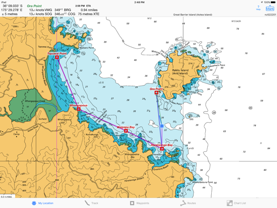
Record a track. View it on the chart, and in a speed and course graph. Record in the background. View date & time of track points.
Mark waypoints by their position on a chart or satellite map, by searching for a place name or address, by tapping a geotagged photo, or by projecting from a known point. Refine a waypoint position when you arrive.
Set a quick GoTo waypoint or a full route and see the course (COG), heading (HDG), bearing (BRG), direction, distance, cross track error (XTE), Velocity Made Good (VMG) and Estimated Time of Arrival (ETA) at your destination and intermediate points.
Man Overboard. With one button push, mark your current position & start navigating to it.
Create routes using waypoints, recorded tracks, or imported GPX, KML or TCX files. Advanced route editing.
Export GPX and KML waypoint, route & track files via eMail, Messages, Copy to, AirDrop, iCloud Drive, Dropbox or iTunes.
Send data to display immediately in Google Earth.
View and share the sun and moon position and rise & set times for any time and any place on earth.
LAND INFORMATION NEW ZEALAND NZ MARINER CHARTS
No extra charge for access to all LINZ NZ Mariner Raster Nautical Charts, with no sign up, no subscription, no in-app purchase required. Download using WiFi or cell service. Charts from our server have a shorter download time and use less of your monthly data allotment.
Store a few charts or charts for the whole country to use anytime at sea without cell service.
Switches automatically between downloaded charts as you sail. Choose detailed or overview charts.
Stitches Mercator charts for seamless coverage across chart boundaries.
Enjoy the high resolution and what's-all-around detail of the NZMariner Raster Nautical Charts (RNC). They are a welcome advantage over Vector Charts, which only show a coastline, depths, navigation aids, and minimal details.
Print and Share chart images overlaid with waypoints, routes & tracks.
Measure distance between any two points.
USE THE UNITS YOU PREFER
Kilometers, Miles, or Nautical Miles. Meters or Feet.
Degrees, Degrees/Minutes, Degrees/Minutes/Seconds, UTM, or NZTM2000 grid.
°True or °Magnetic.
HOW TOS
Tap Help in the app.
Online Manual on iSailGPS.com/nz
Email developer: lwjames@isailgps.com
RASTER CHARTS VS. VECTOR CHARTS
The Land Information New Zealand raster nautical charts in iSailGPS NZ differ from computer-drawn vector charts in that each chart covers a specific area, the same way a paper nautical chart does. Switches automatically to a new chart when your boat leaves the area covered by the previous chart. For many locations, there are multiple charts at different scales with different levels of detail & areas of coverage.
Paper charts can contain multiple panels, each showing a different area or scale. Each digital panel is individually displayed by iSailGPS NZ with a north-up orientation.
iSail GPS NZ is priced to make it readily available to all boating enthusiasts.
DEVICE REQUIREMENTS for this version
No device requires a cellular data plan to use iSail GPS NZ.
iPhone 4S or later, and all WiFi+cellular iPads (iPad 2 or later) support full navigation.
iPad 2 or later with WiFi-only, and iPod touch (5th gen or later) require an iOS-compatible external GPS receiver to show your location on the water and to record tracks. View charts using the iOS device alone.
Sailing becomes safer and more fun with iSail GPS NZ!
On the water in a bad storm and your chart plotter just failed? Download this app now. iSailGPS NZ' s code size is kept very small by efficient programming so in an emergency, you can download it easily even over a weak cell connection. Better yet, buy iSailGPS NZ today so you will already have it if you find yourself in this situation, even in an area with no cell service.
TRACKS, WAYPOINTS & ROUTES
Record a track. View it on the chart, and in a speed and course graph. Record in the background. View date & time of track points.
Mark waypoints by their position on a chart or satellite map, by searching for a place name or address, by tapping a geotagged photo, or by projecting from a known point. Refine a waypoint position when you arrive.
Set a quick GoTo waypoint or a full route and see the course (COG), heading (HDG), bearing (BRG), direction, distance, cross track error (XTE), Velocity Made Good (VMG) and Estimated Time of Arrival (ETA) at your destination and intermediate points.
Man Overboard. With one button push, mark your current position & start navigating to it.
Create routes using waypoints, recorded tracks, or imported GPX, KML or TCX files. Advanced route editing.
Export GPX and KML waypoint, route & track files via eMail, Messages, Copy to, AirDrop, iCloud Drive, Dropbox or iTunes.
Send data to display immediately in Google Earth.
View and share the sun and moon position and rise & set times for any time and any place on earth.
LAND INFORMATION NEW ZEALAND NZ MARINER CHARTS
No extra charge for access to all LINZ NZ Mariner Raster Nautical Charts, with no sign up, no subscription, no in-app purchase required. Download using WiFi or cell service. Charts from our server have a shorter download time and use less of your monthly data allotment.
Store a few charts or charts for the whole country to use anytime at sea without cell service.
Switches automatically between downloaded charts as you sail. Choose detailed or overview charts.
Stitches Mercator charts for seamless coverage across chart boundaries.
Enjoy the high resolution and what's-all-around detail of the NZMariner Raster Nautical Charts (RNC). They are a welcome advantage over Vector Charts, which only show a coastline, depths, navigation aids, and minimal details.
Print and Share chart images overlaid with waypoints, routes & tracks.
Measure distance between any two points.
USE THE UNITS YOU PREFER
Kilometers, Miles, or Nautical Miles. Meters or Feet.
Degrees, Degrees/Minutes, Degrees/Minutes/Seconds, UTM, or NZTM2000 grid.
°True or °Magnetic.
HOW TOS
Tap Help in the app.
Online Manual on iSailGPS.com/nz
Email developer: lwjames@isailgps.com
RASTER CHARTS VS. VECTOR CHARTS
The Land Information New Zealand raster nautical charts in iSailGPS NZ differ from computer-drawn vector charts in that each chart covers a specific area, the same way a paper nautical chart does. Switches automatically to a new chart when your boat leaves the area covered by the previous chart. For many locations, there are multiple charts at different scales with different levels of detail & areas of coverage.
Paper charts can contain multiple panels, each showing a different area or scale. Each digital panel is individually displayed by iSailGPS NZ with a north-up orientation.
iSail GPS NZ is priced to make it readily available to all boating enthusiasts.
DEVICE REQUIREMENTS for this version
No device requires a cellular data plan to use iSail GPS NZ.
iPhone 4S or later, and all WiFi+cellular iPads (iPad 2 or later) support full navigation.
iPad 2 or later with WiFi-only, and iPod touch (5th gen or later) require an iOS-compatible external GPS receiver to show your location on the water and to record tracks. View charts using the iOS device alone.
Sailing becomes safer and more fun with iSail GPS NZ!
 このアプリはiPhone、iPadの両方に対応しています。
カテゴリー
ナビゲーション
ナビゲーション
リリース
2014/9/14
2014/9/14
更新
2021/7/8
2021/7/8
バージョン
9.2.5
9.2.5
言語
サイズ
11.9 MB
11.9 MB
条件
このバージョンの新機能
I'm continually improving this app so it will be even more useful! With this version you can view the moon's phase and you can create a waypoint by simply entering an address.
iSailGPS NZ' s code size is kept very small by efficient programming so in an
I'm continually improving this app so it will be even more useful! With this version you can view the moon's phase and you can create a waypoint by simply entering an address.
iSailGPS NZ' s code size is kept very small by efficient programming so in an
スクリーンショット - iPhone | iPad
スクリーンショット - iPhone | iPad
James Associates Inc. の他のアプリ » もっと見る
» 目的別iPhoneアプリ検索
- 辞書 » 日本語対応の辞書 » 英和辞典
- 学習 » 英単語 » 英会話 » クイズで楽しく
- スケジュール » 管理 » Googleカレンダー


Yahoo!乗換案内
Yahoo Japan Corp.無料
Google マップ - ナビ、乗換案内
Google LLC無料
Yahoo!カーナビ
Yahoo Japan Corp.無料
乗換NAVITIME(乗換ナビタイム) - 運行情報や路線図..
NAVITIME JAPAN CO.,LTD.無料
Yahoo! MAP-ヤフーマップ
Yahoo Japan Corp.無料
乗換案内
Jorudan Co.,Ltd.無料
賃貸物件検索 SUUMO(スーモ)でお部屋探し
Recruit Co.,Ltd.無料
NAVITIME(乗換と地図の総合ナビ)
NAVITIME JAPAN CO.,LTD.無料
NAVITIMEドライブサポーター - カーナビ&渋滞情報&..
NAVITIME JAPAN CO.,LTD.無料
お部屋探しはライフルホームズ賃貸・マンション・不動産物件検索
LIFULL Co., Ltd無料


CatchApp新着アプリレビュー
 日本縦断てつどうの旅」")
様々な楽しみ方で運転士として成長していく鉄道運転士育成RPG「プラチナ・トレイン(プラトレ) 日本縦断てつどうの旅」
2016-05-17 00:00

日本語にはない英語発音のリスニングを楽しく学べる「発音どっち?英語リスニング 」
2014-12-20 12:00

指先の瞬発力が試されるカジュアルゲーム「早撃ちパニック」をリリース!
2014-12-08 15:21
新着アプリ動画
-
 ¥1500
¥1500
-
 ¥600
¥600
-
 ¥3000
¥3000