


このアプリのYoutube動画がある場合はURLを送信してください。詳細 »
APPLICATION INFO - iPhoneアプリの詳細情報
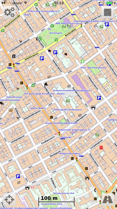
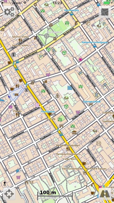
Vectorial Map allows you to view Mapsforge (OpenStreetMap) offline vector maps and record GPS tracks in the background. It supports different map styles, basic track editing and route planning, and online maps.
Features:
- View Mapsforge offline vector maps (.map).
- Change the map's look and feel on the fly using custom Mapsforge XML style sheets.
-* Record GPS tracks in the background.
- Support for slippy format online tile sources (such as OpenStreetMap.org, OpenCycleMaps, Mapquest Aerial/Satellit).
-* Import and edit tracks and waypoints (GPX, KML, KMZ).
-* Draw your own tracks and waypoints (e.g. for trip planning).
-* Calculate routes along up to 50 anchors points (requires internet connection).
- Search for POIs (requires internet connection).
- Capture map screenshots.
- Maps, styles, and track files can be imported using iTunes file sharing and with the iOS "Open in" feature (e.g. using Dropbox, Safari, etc.).
-* Open recorded tracks with other apps using "Open in" feature.
- Support for OSMAnd/Locus offline raster maps (*.sqlitedb).
- Download maps (free) and styles directly in Vectorial Map.
* The features marked with "*" can be enabled with a single one-time in-app-purchase.
More information: http://www.vectorialmap.com/
Vectorial Map Help and Support: http://www.vectorialmap.com/ioshelp
### Manage tracks and waypoints on a Mac/PC ###
The desktop version of Vectorial Map available on the Vectorial Map website (http://www.vectorialmap.com/download) includes a database manager which can be used to easily export, import, and view tracks and waypoints which were recorded with the mobile version of Vectorial Map. More information: http://www.vectorialmap.com/mobiledbmanager
### Contact ###
Please contact us using the contact form if you have questions, feedback, or bug reports: http://www.vectorialmap.com/contact
### Mapsforge ###
Mapsforge is a popular offline vector map format which provides small, but high quality maps which can be easily adapted to custom needs using style sheets.
DISCLAIMER
Vectorial Map uses continuous GPS during tracking. Continued use of GPS running in the background can dramatically decrease battery life.
 このアプリはiPhone、iPadの両方に対応しています。
カテゴリー
ナビゲーション
ナビゲーション
リリース
2014/10/15
2014/10/15
更新
2016/7/3
2016/7/3
バージョン
1.59
1.59
言語
サイズ
17.9 MB
17.9 MB
条件
このバージョンの新機能
Bug fixes
Bug fixes
スクリーンショット - iPhone | iPad
スクリーンショット - iPhone | iPad
Harald Meyer の他のアプリ » もっと見る
» 目的別iPhoneアプリ検索
- 辞書 » 日本語対応の辞書 » 英和辞典
- 学習 » 英単語 » 英会話 » クイズで楽しく
- スケジュール » 管理 » Googleカレンダー


CatchApp新着アプリレビュー
 日本縦断てつどうの旅」")
様々な楽しみ方で運転士として成長していく鉄道運転士育成RPG「プラチナ・トレイン(プラトレ) 日本縦断てつどうの旅」
2016-05-17 00:00

日本語にはない英語発音のリスニングを楽しく学べる「発音どっち?英語リスニング 」
2014-12-20 12:00

指先の瞬発力が試されるカジュアルゲーム「早撃ちパニック」をリリース!
2014-12-08 15:21
新着アプリ動画
-
 ¥1500
¥1500

-
 ¥600
¥600
-
 ¥3000
¥3000