


このアプリのYoutube動画がある場合はURLを送信してください。詳細 »
APPLICATION INFO - iPhoneアプリの詳細情報
[DESCRIPTION]
Elevate your tactical planning and navigation with Achilleus 3D Tactical Map. Designed for military professionals, this cutting-edge app provides unparalleled situational awareness and precision. With 3D terrain visualization, real-time data, and advanced features, you can confidently execute missions and operations.
Key Features:
- 3D Terrain Maps: Visualize your surroundings with lifelike 3D terrain maps for precise planning.
- Real-Time Data: Solunar data, GPS coordinates and mission-critical updates.
- Waypoint Navigation: Easily set waypoints and navigate with utmost accuracy.
- Offline Maps: Download maps for offline use in remote locations.
- Secure & Encrypted: Your data's security is our top priority.
- Custom Tools: Tailor the app to your mission's specific requirements.
Achilleus 3D Tactical Map is your trusted companion in the field, ensuring you're always in control. Upgrade your military navigation – download now!
*** Achilleus 3D is under active development and will have new features and improvements in the future. ***
- Achilleus 3D is a Tactical Map and Navigation tool, designed to maximize situational awareness and operational readiness.
- Simple, intuitive interface that can be operated easily with one hand.
Plan and organize your mission!
[MAPPING]
- 2D maps and 3D maps with elevation.
- Online and Offline Maps (Virtual Earth, Google Satellite, OpenTopo, OpenStreetMap, ArcGIS Satellite, Nokia).
- Tool for cache map and elevation data for offline use.
- Automatically cache Map and Elevation data and can be used when you are offline.
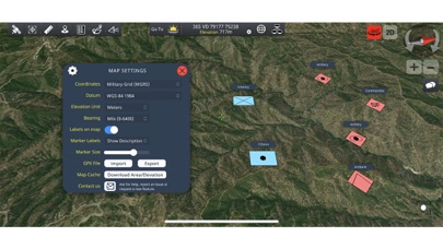
- Military Grid Reference System (MGRS) & United States National Grid (USNG).
- British National Grid (BNG)
- Supports various map DATUM formats.
- Latitude/Longitude degrees.
- Universal Transverse Mercator (UTM).
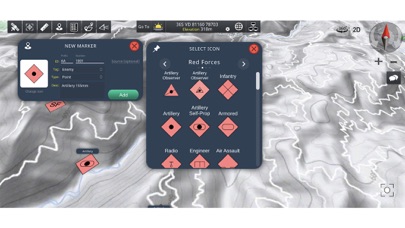
- Create and navigate to waypoints.
- Use the crosshair to position new waypoints.
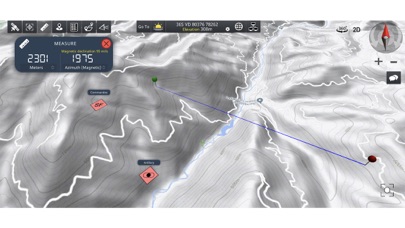
- Measure distances.
- Measure bearings (mils, degrees).
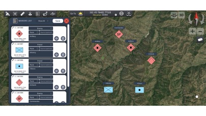
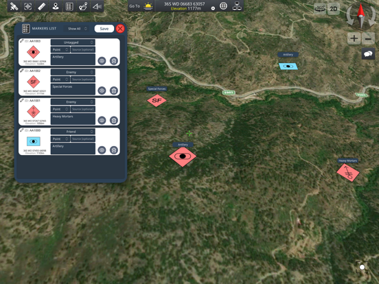
- Markers Management tool (Add ID, description, tags etc...).
[GPS NAVIGATION]
- 2D and 3D Navigation. Draw your route to destination.
- Use compass to rotate map, while you travel.
- Get speed, total distance and time to destination.
- GPS current location and altitude in real time.
[NETWORK]
With the new Network feature, users can share their map status and chat at the same time over a TCP/IP network. No external server needed! You can use your iOS device as a Server OR connect to a network as a client.
Military leaders must be able to command and control the many activities of their forces to accomplish their missions.
- LIVE Monitoring Map of users activity over the network.
- SHARE your map markers with other users.
- CHAT with other users over the network.
- No server needed! Achilleus 3D network is working through TCP/IP. No external server needed! Use your iOS device as a Server OR connect to a network as a client.
- Due to cellular providers restriction, you cannot host a local area network from your iOS device while you are connected to a cellular connection. Please use a local network wifi or connect to another server.
[MILITARY SYMBOLOGY]
- Includes basic Joint Military Symbology (MIL-STD-2525D).
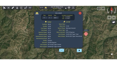
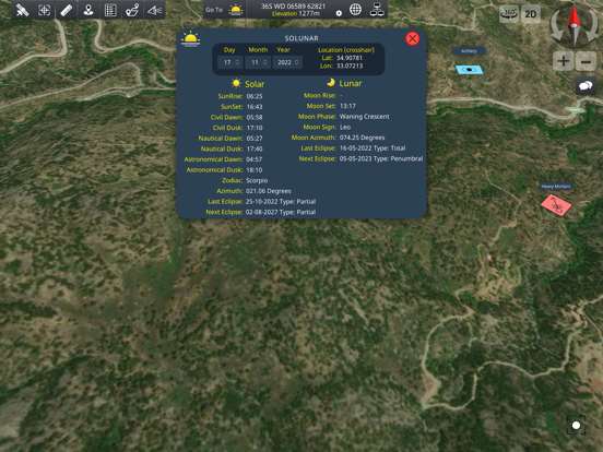
[SOLAR & LUNAR INFORMATION]
- Wide array of location based Solar/Lunar information such as Rise/Set times, phase info and more (works offline).
NOTE: Using GPS will shorten battery life.
Elevate your tactical planning and navigation with Achilleus 3D Tactical Map. Designed for military professionals, this cutting-edge app provides unparalleled situational awareness and precision. With 3D terrain visualization, real-time data, and advanced features, you can confidently execute missions and operations.
Key Features:
- 3D Terrain Maps: Visualize your surroundings with lifelike 3D terrain maps for precise planning.
- Real-Time Data: Solunar data, GPS coordinates and mission-critical updates.
- Waypoint Navigation: Easily set waypoints and navigate with utmost accuracy.
- Offline Maps: Download maps for offline use in remote locations.
- Secure & Encrypted: Your data's security is our top priority.
- Custom Tools: Tailor the app to your mission's specific requirements.
Achilleus 3D Tactical Map is your trusted companion in the field, ensuring you're always in control. Upgrade your military navigation – download now!
*** Achilleus 3D is under active development and will have new features and improvements in the future. ***
- Achilleus 3D is a Tactical Map and Navigation tool, designed to maximize situational awareness and operational readiness.
- Simple, intuitive interface that can be operated easily with one hand.
Plan and organize your mission!
[MAPPING]
- 2D maps and 3D maps with elevation.
- Online and Offline Maps (Virtual Earth, Google Satellite, OpenTopo, OpenStreetMap, ArcGIS Satellite, Nokia).
- Tool for cache map and elevation data for offline use.
- Automatically cache Map and Elevation data and can be used when you are offline.
- Military Grid Reference System (MGRS) & United States National Grid (USNG).
- British National Grid (BNG)
- Supports various map DATUM formats.
- Latitude/Longitude degrees.
- Universal Transverse Mercator (UTM).
- Create and navigate to waypoints.
- Use the crosshair to position new waypoints.
- Measure distances.
- Measure bearings (mils, degrees).
- Markers Management tool (Add ID, description, tags etc...).
[GPS NAVIGATION]
- 2D and 3D Navigation. Draw your route to destination.
- Use compass to rotate map, while you travel.
- Get speed, total distance and time to destination.
- GPS current location and altitude in real time.
[NETWORK]
With the new Network feature, users can share their map status and chat at the same time over a TCP/IP network. No external server needed! You can use your iOS device as a Server OR connect to a network as a client.
Military leaders must be able to command and control the many activities of their forces to accomplish their missions.
- LIVE Monitoring Map of users activity over the network.
- SHARE your map markers with other users.
- CHAT with other users over the network.
- No server needed! Achilleus 3D network is working through TCP/IP. No external server needed! Use your iOS device as a Server OR connect to a network as a client.
- Due to cellular providers restriction, you cannot host a local area network from your iOS device while you are connected to a cellular connection. Please use a local network wifi or connect to another server.
[MILITARY SYMBOLOGY]
- Includes basic Joint Military Symbology (MIL-STD-2525D).
[SOLAR & LUNAR INFORMATION]
- Wide array of location based Solar/Lunar information such as Rise/Set times, phase info and more (works offline).
NOTE: Using GPS will shorten battery life.
 このアプリはiPhone、iPadの両方に対応しています。
カテゴリー
ナビゲーション
ナビゲーション
リリース
2020/5/3
2020/5/3
更新
2023/11/20
2023/11/20
バージョン
3.4.3
3.4.3
言語
サイズ
173.4 MB
173.4 MB
条件
このバージョンの新機能
- [NEW] Change Terrain elevation 3D scale.
- [NEW] Added the possibility to add Polar coordinates from GPS Location to target tool. You can set Polar coordinates (distance and bearing) and view on map the calculated position. Bearing can be true or azimut
- [NEW] Change Terrain elevation 3D scale.
- [NEW] Added the possibility to add Polar coordinates from GPS Location to target tool. You can set Polar coordinates (distance and bearing) and view on map the calculated position. Bearing can be true or azimut
スクリーンショット - iPhone | iPad
スクリーンショット - iPhone | iPad
Savvas Petrou の他のアプリ » もっと見る
» 目的別iPhoneアプリ検索
- 辞書 » 日本語対応の辞書 » 英和辞典
- 学習 » 英単語 » 英会話 » クイズで楽しく
- スケジュール » 管理 » Googleカレンダー


Yahoo!乗換案内
Yahoo Japan Corp.無料
Google マップ - ナビ、乗換案内
Google LLC無料
Yahoo!カーナビ
Yahoo Japan Corp.無料
乗換NAVITIME(乗換ナビタイム) - 運行情報や路線図..
NAVITIME JAPAN CO.,LTD.無料
Yahoo! MAP-ヤフーマップ
Yahoo Japan Corp.無料
乗換案内
Jorudan Co.,Ltd.無料
賃貸物件検索 SUUMO(スーモ)でお部屋探し
Recruit Co.,Ltd.無料
NAVITIME(乗換と地図の総合ナビ)
NAVITIME JAPAN CO.,LTD.無料
NAVITIMEドライブサポーター - カーナビ&渋滞情報&..
NAVITIME JAPAN CO.,LTD.無料
お部屋探しはライフルホームズ賃貸・マンション・不動産物件検索
LIFULL Co., Ltd無料


CatchApp新着アプリレビュー
 日本縦断てつどうの旅」")
様々な楽しみ方で運転士として成長していく鉄道運転士育成RPG「プラチナ・トレイン(プラトレ) 日本縦断てつどうの旅」
2016-05-17 00:00

日本語にはない英語発音のリスニングを楽しく学べる「発音どっち?英語リスニング 」
2014-12-20 12:00

指先の瞬発力が試されるカジュアルゲーム「早撃ちパニック」をリリース!
2014-12-08 15:21
新着アプリ動画
-
 ¥1500
¥1500
-
 ¥600
¥600
-
 ¥3000
¥3000