


このアプリのYoutube動画がある場合はURLを送信してください。詳細 »
APPLICATION INFO - iPhoneアプリの詳細情報
From the producers of GB Maps (featured in Ordnance Survey's OS OpenData innovative application showcase)
Beautifully detailed maps supplied by Ordnance Survey and optimally styled for mobile devices by our highly skilled cartography specialists.
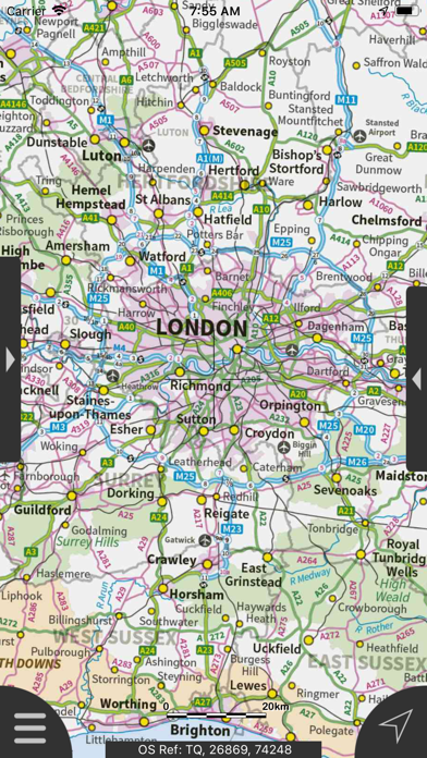
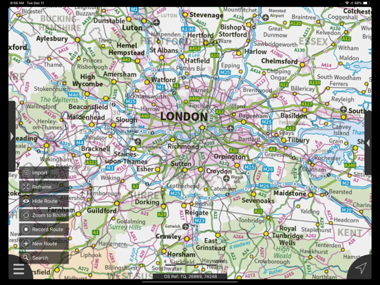
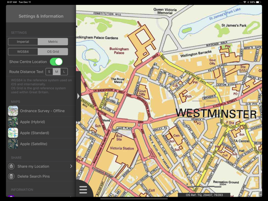
London Maps Offline provides a useful offline mapping reference and navigation aid whilst travelling throughout London by roadside, road, rail, canal, lake and river. A powerful offline search facility can locate places, roads, post codes and hills within the region. It also provides worldwide online Apple maps (Standard, Satellite and Hybrid). Map features that you are used to with Apple maps are available on both offline and online maps as well as providing 3D buildings on Apple maps (where available).
Map features:
- 7 different levels of offline 2014/2015 Ordnance Survey map detail from national overview to street view within the region. (No data connection required)
Progressively more detailed maps are automatically loaded as the map view is zoomed. The maps seamlessly transition from one level of detail to the next. The OS recommended viewing scales for the more detailed maps are approximately as follows:
1:1000,000 (Whole of GB)
1:250,000
1:50,000
1:25,000
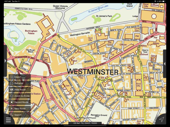
1:10,000 (Roads/streets are labelled)
The map region of the more detailed maps covers a rectangular region around the M25 orbital motorway, The following locations, which are outside of the M25 are included : Woking, Guildford, Fetcham, Leatherhead, Dorking, Redhill, Reigate, Sevenoaks, Epping, Amersham, Beaconsfield, Slough & Windsor .
London Underground stations, hospitals, airports and other features are marked on some of the more detailed maps.
App features:
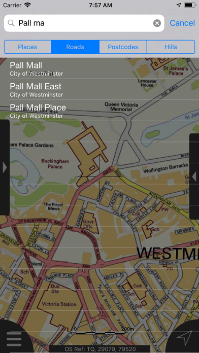
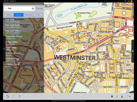
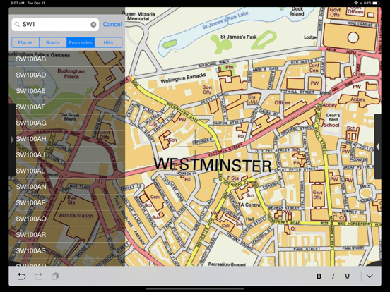
- Offline search functionality with searchable locations (places, roads, post codes and hills). (For the place search a location's latitude and longitude is accurate to 0.1 of a minute of the centre point of the 1x1 km National Grid square in which the name falls)
- Detailed hill information, including height, OS Grid Ref, latitude and longitude, region, parent, classification, drop and hill specific links to Streetmap, Geograph and Hill Bagging web sites
- Display of current GPS position as OS Grid Reference or WGS84 latitude and longitude
- "Share My Location" allowing users to share an image of their current location and location references. Buttons are provided to share location information by Facebook, Twitter, iMessage/SMS and e-mail
- Online access to worldwide Apple Standard, Satellite and Hybrid maps
- Apple 3D Buildings are displayed on Apple Standard maps
- Apple maps contain Points of Interest
- User location can be tracked with or without heading on all online and offline maps (GPS capable devices only)
- Display of scale bar in either metric or imperial units
- Display of current speed
- Zoom, pan, rotation of all maps
- Pitch of Apple Standard and Ordnance Survey maps
- Selection of current location annotation for display of speed and location data
- User setting for speed display in Miles per Hour (mph) or Kilometres per Hour (kph)
- Selection of search result pin annotations to display location information
- Collective deletion of search result annotation pins
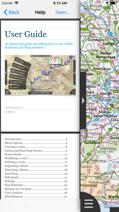
- A user guide is provided within the app information
Further application details.
The post code, place name and road name data was published by Ordnance Survey in 2014.
Extracts from "The Database of British and Irish Hills" v14 published 22/04/2014 (ref. http://www.hills-database.co.uk/index.html )
Disclaimers
The data is as supplied by Apple, Ordnance Survey and Database of British and Irish Hills. Maps have been custom styled and transformed to the Spherical Mercator Coordinate Reference System (CRS). JOMO Solutions does not guarantee the accuracy of any of the data within the application.
Beautifully detailed maps supplied by Ordnance Survey and optimally styled for mobile devices by our highly skilled cartography specialists.
London Maps Offline provides a useful offline mapping reference and navigation aid whilst travelling throughout London by roadside, road, rail, canal, lake and river. A powerful offline search facility can locate places, roads, post codes and hills within the region. It also provides worldwide online Apple maps (Standard, Satellite and Hybrid). Map features that you are used to with Apple maps are available on both offline and online maps as well as providing 3D buildings on Apple maps (where available).
Map features:
- 7 different levels of offline 2014/2015 Ordnance Survey map detail from national overview to street view within the region. (No data connection required)
Progressively more detailed maps are automatically loaded as the map view is zoomed. The maps seamlessly transition from one level of detail to the next. The OS recommended viewing scales for the more detailed maps are approximately as follows:
1:1000,000 (Whole of GB)
1:250,000
1:50,000
1:25,000
1:10,000 (Roads/streets are labelled)
The map region of the more detailed maps covers a rectangular region around the M25 orbital motorway, The following locations, which are outside of the M25 are included : Woking, Guildford, Fetcham, Leatherhead, Dorking, Redhill, Reigate, Sevenoaks, Epping, Amersham, Beaconsfield, Slough & Windsor .
London Underground stations, hospitals, airports and other features are marked on some of the more detailed maps.
App features:
- Offline search functionality with searchable locations (places, roads, post codes and hills). (For the place search a location's latitude and longitude is accurate to 0.1 of a minute of the centre point of the 1x1 km National Grid square in which the name falls)
- Detailed hill information, including height, OS Grid Ref, latitude and longitude, region, parent, classification, drop and hill specific links to Streetmap, Geograph and Hill Bagging web sites
- Display of current GPS position as OS Grid Reference or WGS84 latitude and longitude
- "Share My Location" allowing users to share an image of their current location and location references. Buttons are provided to share location information by Facebook, Twitter, iMessage/SMS and e-mail
- Online access to worldwide Apple Standard, Satellite and Hybrid maps
- Apple 3D Buildings are displayed on Apple Standard maps
- Apple maps contain Points of Interest
- User location can be tracked with or without heading on all online and offline maps (GPS capable devices only)
- Display of scale bar in either metric or imperial units
- Display of current speed
- Zoom, pan, rotation of all maps
- Pitch of Apple Standard and Ordnance Survey maps
- Selection of current location annotation for display of speed and location data
- User setting for speed display in Miles per Hour (mph) or Kilometres per Hour (kph)
- Selection of search result pin annotations to display location information
- Collective deletion of search result annotation pins
- A user guide is provided within the app information
Further application details.
The post code, place name and road name data was published by Ordnance Survey in 2014.
Extracts from "The Database of British and Irish Hills" v14 published 22/04/2014 (ref. http://www.hills-database.co.uk/index.html )
Disclaimers
The data is as supplied by Apple, Ordnance Survey and Database of British and Irish Hills. Maps have been custom styled and transformed to the Spherical Mercator Coordinate Reference System (CRS). JOMO Solutions does not guarantee the accuracy of any of the data within the application.
 このアプリはiPhone、iPadの両方に対応しています。
カテゴリー
ナビゲーション
ナビゲーション
リリース
2015/2/10
2015/2/10
更新
2015/5/4
2015/5/4
バージョン
1.3.0
1.3.0
言語
サイズ
297.3 MB
297.3 MB
条件
このバージョンの新機能
This new release showcases all the apps in the current collection of app offerings. Please have a look at the "Product Range" within the app's information section to view our extensive range of National Park map apps which are proving to be popular. We
This new release showcases all the apps in the current collection of app offerings. Please have a look at the "Product Range" within the app's information section to view our extensive range of National Park map apps which are proving to be popular. We
スクリーンショット - iPhone | iPad
スクリーンショット - iPhone | iPad
JOMO Solutions Ltd の他のアプリ » もっと見る
» 目的別iPhoneアプリ検索
- 辞書 » 日本語対応の辞書 » 英和辞典
- 学習 » 英単語 » 英会話 » クイズで楽しく
- スケジュール » 管理 » Googleカレンダー


Yahoo!乗換案内
Yahoo Japan Corp.無料
Google マップ - ナビ、乗換案内
Google LLC無料
Yahoo!カーナビ
Yahoo Japan Corp.無料
乗換NAVITIME(乗換ナビタイム) - 運行情報や路線図..
NAVITIME JAPAN CO.,LTD.無料
Yahoo! MAP-ヤフーマップ
Yahoo Japan Corp.無料
乗換案内
Jorudan Co.,Ltd.無料
賃貸物件検索 SUUMO(スーモ)でお部屋探し
Recruit Co.,Ltd.無料
NAVITIME(乗換と地図の総合ナビ)
NAVITIME JAPAN CO.,LTD.無料
NAVITIMEドライブサポーター - カーナビ&渋滞情報&..
NAVITIME JAPAN CO.,LTD.無料
お部屋探しはライフルホームズ賃貸・マンション・不動産物件検索
LIFULL Co., Ltd無料


CatchApp新着アプリレビュー
 日本縦断てつどうの旅」")
様々な楽しみ方で運転士として成長していく鉄道運転士育成RPG「プラチナ・トレイン(プラトレ) 日本縦断てつどうの旅」
2016-05-17 00:00

日本語にはない英語発音のリスニングを楽しく学べる「発音どっち?英語リスニング 」
2014-12-20 12:00

指先の瞬発力が試されるカジュアルゲーム「早撃ちパニック」をリリース!
2014-12-08 15:21
新着アプリ動画
-
 ¥1500
¥1500
-
 ¥600
¥600
-
 ¥3000
¥3000