


このアプリのYoutube動画がある場合はURLを送信してください。詳細 »
APPLICATION INFO - iPhoneアプリの詳細情報
TOP > ヘルスケア/フィットネス > San Diego Hikes
Paper Maps — Hike & Bike in San Diego's premier open space parks. A Paper Map is needed for every trail.
Use your GPS to see your location on the trail.
Features
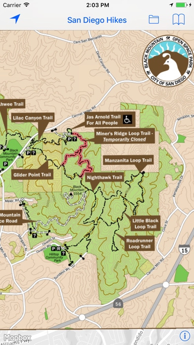
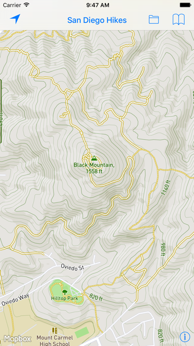
— Topo maps and contour maps of San Diego Bike and Hike trails
— Contours in Imperial units (feet instead of meters)
— Hikes added for:
— Torrey Pines State Natural Reserve
— Black Mountain Open Space Preserve
— Mission Trails Regional Park
— Mount Woodson
— Iron Mountain
With over 7,000 acres, Mission Trails is one of the largest urban parks in the country, providing opportunities for recreation as well as native flora and fauna viewing. Mission Trails is home to Cowles Mountain, East Fortuna Staging Area (Equestrian Staging Area), Kumeyaay Lake and Campground, Old Mission Dam Historic Site, Kwaay Paay Peak, and many additional areas to hike, bike, observe and explore.
Black Mountain Open Space Park is owned and managed by the City of San Diego and is made up of a series of chaparral and sage covered hills, ridges, and canyons. The park is currently 2,352 acres.
Mount Woodson and Iron Mountain are located in Poway.
Usage
— Pan to move
— Pinch to zoom
— Use two fingers to rotate
— Double-tap to zoom in one level
— Two-finger single-tap to zoom out one level
— Double-tap, long-pressing the second, then pan up and down to "quick zoom" (one hand mode)
Legal —
This application and its supporting data are provided as a free service to hikers and bikers. We believe the information, its presentation and the computations based upon it are accurate but they may contain errors. This application and its supporting data are distributed in the hope they will be useful, but are conveyed WITHOUT ANY WARRANTY and without implied warranty of MERCHANTABILITY or FITNESS FOR A PARTICULAR PURPOSE.
Publisher assumes no liability for safety or condition of roads or trails. Map is not intended for navigational use and is not represented to be correct in every aspect. Consult federal, state, and local laws for current regulations.
Paper Maps — Hiking responsible since 2015. Paper Maps is powered by Mapbox. Maps use Mapbox GL with high performance vector based maps.
Black Mountain and Mission Trails maps are © City of San Diego
Use your GPS to see your location on the trail.
Features
— Topo maps and contour maps of San Diego Bike and Hike trails
— Contours in Imperial units (feet instead of meters)
— Hikes added for:
— Torrey Pines State Natural Reserve
— Black Mountain Open Space Preserve
— Mission Trails Regional Park
— Mount Woodson
— Iron Mountain
With over 7,000 acres, Mission Trails is one of the largest urban parks in the country, providing opportunities for recreation as well as native flora and fauna viewing. Mission Trails is home to Cowles Mountain, East Fortuna Staging Area (Equestrian Staging Area), Kumeyaay Lake and Campground, Old Mission Dam Historic Site, Kwaay Paay Peak, and many additional areas to hike, bike, observe and explore.
Black Mountain Open Space Park is owned and managed by the City of San Diego and is made up of a series of chaparral and sage covered hills, ridges, and canyons. The park is currently 2,352 acres.
Mount Woodson and Iron Mountain are located in Poway.
Usage
— Pan to move
— Pinch to zoom
— Use two fingers to rotate
— Double-tap to zoom in one level
— Two-finger single-tap to zoom out one level
— Double-tap, long-pressing the second, then pan up and down to "quick zoom" (one hand mode)
Legal —
This application and its supporting data are provided as a free service to hikers and bikers. We believe the information, its presentation and the computations based upon it are accurate but they may contain errors. This application and its supporting data are distributed in the hope they will be useful, but are conveyed WITHOUT ANY WARRANTY and without implied warranty of MERCHANTABILITY or FITNESS FOR A PARTICULAR PURPOSE.
Publisher assumes no liability for safety or condition of roads or trails. Map is not intended for navigational use and is not represented to be correct in every aspect. Consult federal, state, and local laws for current regulations.
Paper Maps — Hiking responsible since 2015. Paper Maps is powered by Mapbox. Maps use Mapbox GL with high performance vector based maps.
Black Mountain and Mission Trails maps are © City of San Diego
 このアプリはiPhone、iPadの両方に対応しています。
カテゴリー
ヘルスケア/フィットネス
ヘルスケア/フィットネス
リリース
2016/1/29
2016/1/29
更新
2016/6/9
2016/6/9
バージョン
2.28
2.28
言語
サイズ
31 MB
31 MB
条件
このバージョンの新機能
— Topo maps and contour maps of San Diego Bike and Hike trails
— Contours in Imperial units (feet instead of meters)
— New hikes added for:
— Torrey Pines State Natural Reserve
— Powered by Mapbox for iOS SDK 3.2.2
— Topo maps and contour maps of San Diego Bike and Hike trails
— Contours in Imperial units (feet instead of meters)
— New hikes added for:
— Torrey Pines State Natural Reserve
— Powered by Mapbox for iOS SDK 3.2.2
スクリーンショット - iPhone | iPad
スクリーンショット - iPhone | iPad
ePi Rational, Inc. の他のアプリ » もっと見る
» 目的別iPhoneアプリ検索
- 辞書 » 日本語対応の辞書 » 英和辞典
- 学習 » 英単語 » 英会話 » クイズで楽しく
- スケジュール » 管理 » Googleカレンダー


快眠の森〜寝言を解析します〜
ASD Corporation無料
Sleep Meister - 睡眠サイクルアラーム Lit..
Naoya Araki無料
簡単ダイエット!おさんぽハローキティ
sanrio無料
どこでもミラー 300万人愛用 便利な鏡アプリ
and factory, Inc無料
ルナルナ : 無料で生理/排卵日予測 生理日管理アプリ
MTI Ltd.無料
睡眠アプリ
koikoi.biz100 円
シンプル・ダイエット 〜 記録するだけ!かんたん体重管理 〜
i-mobile Co.,Ltd無料
快眠サイクル時計 [目覚ましアラーム]
Ateam Entertainment Inc.無料
ラルーン -生理の管理から妊活も 生理周期、生理管理アプリ
Medley, Inc.無料
あすけん ダイエットアプリで無料のカロリー計算・体重管理・食..
asken inc. (Tokyo)無料


CatchApp新着アプリレビュー
 日本縦断てつどうの旅」")
様々な楽しみ方で運転士として成長していく鉄道運転士育成RPG「プラチナ・トレイン(プラトレ) 日本縦断てつどうの旅」
2016-05-17 00:00

日本語にはない英語発音のリスニングを楽しく学べる「発音どっち?英語リスニング 」
2014-12-20 12:00

指先の瞬発力が試されるカジュアルゲーム「早撃ちパニック」をリリース!
2014-12-08 15:21
新着アプリ動画
-
 ¥1500
¥1500
-
 ¥600
¥600
-
 ¥3000
¥3000