


このアプリのYoutube動画がある場合はURLを送信してください。詳細 »
APPLICATION INFO - iPhoneアプリの詳細情報

-

- Share on Tumblr
- Check
- ツイート
This App offers access to CHS marine vector & raster charts. First marine GPS app to have route assistance with Voice Prompts for marine navigation. You can create new boating routes or import existing GPX/KML routes. It supports Nautical Charts course up orientation. Includes Tide & Currents prediction.
(Includes coverage for Trent Severn Waterway incl. lake Simcoe etc.)
►FEATURES
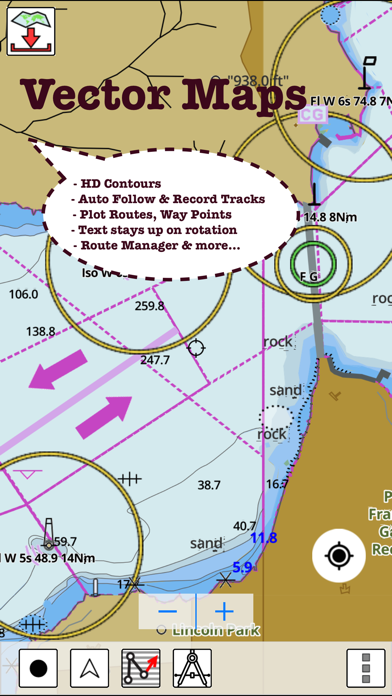
√ Beautiful and detailed Hardware/GPU accelerated vector charts (text stays upright on rotation)
√ Long press to query the details of Marine object (Buoy, Lights, Obstruction etc).
√ Customizable depth(Ft/Fathom/Meter) and distance units (km/mi/NM)
√ Customizable Shallow Depth.
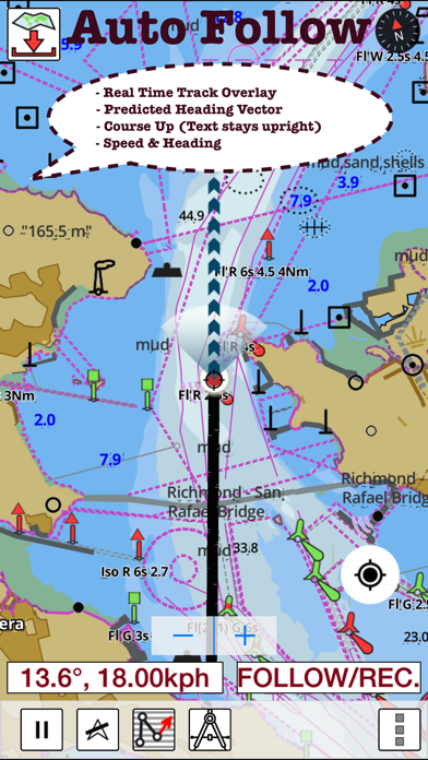
√ Record tracks, Autofollow with real-time track overlay & predicted path vector.
√ Voice Prompts for marine navigation (requires GPS )
√ 1ft / 3ft depth contour maps for anglers for selected lake maps.
√ Supports GPX/KML for boating route editing/import.
√ Tide & Currents prediction.
√ Seamless chart quilting of marine charts
√ Enter or import Waypoints.
► MAPS
The maps include coverage of Pacific Coast, Central Canada(incl. Great Lakes, Trent Severn Waterway, Ontario Lakes), Atlantic coast derived from CHS data.
►ROUTE MANAGEMENT / TRIP PLANNING
√ Create New Route/Edit Existing Routes
√ Move Points
√ Add points to an existing route leg
√ Delete / Rename points
√ Import GPX, KML & KMZ files
√ Plot/Edit Routes
√ Enter Waypoints
√ Share/Export Routes, Tracks & Markers
√ Reverse Routes
►GPS FEATURES
√ Auto Follow
* Real Time Track Overlay
* Predicted Path Vector
* Course Up (Text stays upright)
* Speed & Heading
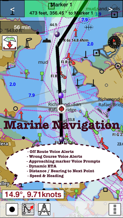
√ Route Assistance With Voice Prompts
* Prompts when approaching a boating route marker
* Continous distance and ETA updates
* Alerts when sailing/boating off route
* Alerts when boating in wrong direction
√ Record Tracks
►TIDE & CURRENTS
* For US, Canada, UK, Germany & New Zealand
* High/Low Tides
* Tidal Current Prediction
* Active Current Stations
►Instrumentation
√ Marine AIS & (NMEA AIS and GPS over TCP/UDP)
√ Wind direction & Speed,Sonar depth,Water temperature
► SHARING
* Share tracks/routes/markers on Facebook & Twitter
* Export tracks/routes/markers as compressed GPX files.
Sample Nautical Charts
►Rainy Lake and Lake of the Woods
►Quebec to Anticosti Island West
►Gulf of St. Lawrence South
►Ontario Lakes
►Trent-Severn Waterway
►Labrador Coast
►Lac Saint Jean
►Rideau Canal - Ottawa River
►Georgian Bay
►Newfoundland East and South
►Great lakes Canada and St. Lawrence river
►Lakes and Rivers in Manitoba and Saskatchewan
►Lakes and Rivers of British Columbia
►Pacific Coast - Vancouver Island East & West - Haida Gwaii
►Lakes around Georgian Bay
►Gulf of St. Lawrence North - Newfoundland West
►Alberta Lakes
►Nova Scotia South - Bay of Fundy
Vancouver Island Ile de Vancouver, Juan de Fuca Strait Queen Charlotte Sound
Strait of Georgia, Southern Portion Partie Sud
Lake Ontario Lac Ontario
LAKE SIMCOE
Strait of Georgia, Central Portion Partie Centrale
BIG CHUTE MARINE RAILWAYS BER ROULANT
Strait of Georgia, Northern Portion Partie Nord
Georgian Bay Baie Georgienne
Strait of Georgia, Central Portion Partie Centrale
North Pender Island to a Thetis Island
Thetis Island to a Nanaimo
Juan de Fuca Strait to a Strait of Georgia
Howe Sound
Active Pass
Nanaimo Harbour and et Departure Bay
LAKE ROSSEAU AND/ET LAKE JOSEPH
Haro Strait, Boundary Pass and et Satellite Channel
Approaches to Approches a Vancouver Harbour
Vancouver Harbour, Western Portion Partie Ouest
Telegraph Harbour and et Preedy Harbour
Ganges Harbour and et Long Harbour
Dodd Narrows to a Flat Top Islands
Baynes Sound
Approaches to Approches a Sidney
Desolation Sound and et Sutil Channel
Porlier Pass
Fraser River Fleuve Fraser, Strait of Georgia Mitchell Island
Fraser River
Battery Disclaimer: Continued use of GPS running in the background can dramatically decrease battery life.
(Includes coverage for Trent Severn Waterway incl. lake Simcoe etc.)
►FEATURES
√ Beautiful and detailed Hardware/GPU accelerated vector charts (text stays upright on rotation)
√ Long press to query the details of Marine object (Buoy, Lights, Obstruction etc).
√ Customizable depth(Ft/Fathom/Meter) and distance units (km/mi/NM)
√ Customizable Shallow Depth.
√ Record tracks, Autofollow with real-time track overlay & predicted path vector.
√ Voice Prompts for marine navigation (requires GPS )
√ 1ft / 3ft depth contour maps for anglers for selected lake maps.
√ Supports GPX/KML for boating route editing/import.
√ Tide & Currents prediction.
√ Seamless chart quilting of marine charts
√ Enter or import Waypoints.
► MAPS
The maps include coverage of Pacific Coast, Central Canada(incl. Great Lakes, Trent Severn Waterway, Ontario Lakes), Atlantic coast derived from CHS data.
►ROUTE MANAGEMENT / TRIP PLANNING
√ Create New Route/Edit Existing Routes
√ Move Points
√ Add points to an existing route leg
√ Delete / Rename points
√ Import GPX, KML & KMZ files
√ Plot/Edit Routes
√ Enter Waypoints
√ Share/Export Routes, Tracks & Markers
√ Reverse Routes
►GPS FEATURES
√ Auto Follow
* Real Time Track Overlay
* Predicted Path Vector
* Course Up (Text stays upright)
* Speed & Heading
√ Route Assistance With Voice Prompts
* Prompts when approaching a boating route marker
* Continous distance and ETA updates
* Alerts when sailing/boating off route
* Alerts when boating in wrong direction
√ Record Tracks
►TIDE & CURRENTS
* For US, Canada, UK, Germany & New Zealand
* High/Low Tides
* Tidal Current Prediction
* Active Current Stations
►Instrumentation
√ Marine AIS & (NMEA AIS and GPS over TCP/UDP)
√ Wind direction & Speed,Sonar depth,Water temperature
► SHARING
* Share tracks/routes/markers on Facebook & Twitter
* Export tracks/routes/markers as compressed GPX files.
Sample Nautical Charts
►Rainy Lake and Lake of the Woods
►Quebec to Anticosti Island West
►Gulf of St. Lawrence South
►Ontario Lakes
►Trent-Severn Waterway
►Labrador Coast
►Lac Saint Jean
►Rideau Canal - Ottawa River
►Georgian Bay
►Newfoundland East and South
►Great lakes Canada and St. Lawrence river
►Lakes and Rivers in Manitoba and Saskatchewan
►Lakes and Rivers of British Columbia
►Pacific Coast - Vancouver Island East & West - Haida Gwaii
►Lakes around Georgian Bay
►Gulf of St. Lawrence North - Newfoundland West
►Alberta Lakes
►Nova Scotia South - Bay of Fundy
Vancouver Island Ile de Vancouver, Juan de Fuca Strait Queen Charlotte Sound
Strait of Georgia, Southern Portion Partie Sud
Lake Ontario Lac Ontario
LAKE SIMCOE
Strait of Georgia, Central Portion Partie Centrale
BIG CHUTE MARINE RAILWAYS BER ROULANT
Strait of Georgia, Northern Portion Partie Nord
Georgian Bay Baie Georgienne
Strait of Georgia, Central Portion Partie Centrale
North Pender Island to a Thetis Island
Thetis Island to a Nanaimo
Juan de Fuca Strait to a Strait of Georgia
Howe Sound
Active Pass
Nanaimo Harbour and et Departure Bay
LAKE ROSSEAU AND/ET LAKE JOSEPH
Haro Strait, Boundary Pass and et Satellite Channel
Approaches to Approches a Vancouver Harbour
Vancouver Harbour, Western Portion Partie Ouest
Telegraph Harbour and et Preedy Harbour
Ganges Harbour and et Long Harbour
Dodd Narrows to a Flat Top Islands
Baynes Sound
Approaches to Approches a Sidney
Desolation Sound and et Sutil Channel
Porlier Pass
Fraser River Fleuve Fraser, Strait of Georgia Mitchell Island
Fraser River
Battery Disclaimer: Continued use of GPS running in the background can dramatically decrease battery life.
 このアプリはiPhone、iPadの両方に対応しています。
カテゴリー
ナビゲーション
ナビゲーション
リリース
2015/8/3
2015/8/3
更新
2016/6/22
2016/6/22
バージョン
60.0.0
60.0.0
言語
サイズ
22.7 MB
22.7 MB
条件
このバージョンの新機能
►Instrumentation
√ Marine AIS & (NMEA AIS and GPS over TCP/UDP)
√ Wind direction & Speed,Sonar depth,Water temperature
►Support for Aerial Imagery, Regular Street maps
►Instrumentation
√ Marine AIS & (NMEA AIS and GPS over TCP/UDP)
√ Wind direction & Speed,Sonar depth,Water temperature
►Support for Aerial Imagery, Regular Street maps
スクリーンショット - iPhone | iPad
スクリーンショット - iPhone | iPad
Bist LLC の他のアプリ » もっと見る
» 目的別iPhoneアプリ検索
- 辞書 » 日本語対応の辞書 » 英和辞典
- 学習 » 英単語 » 英会話 » クイズで楽しく
- スケジュール » 管理 » Googleカレンダー


Yahoo!乗換案内
Yahoo Japan Corp.無料
Google マップ - ナビ、乗換案内
Google LLC無料
Yahoo!カーナビ
Yahoo Japan Corp.無料
乗換NAVITIME(乗換ナビタイム) - 運行情報や路線図..
NAVITIME JAPAN CO.,LTD.無料
Yahoo! MAP-ヤフーマップ
Yahoo Japan Corp.無料
乗換案内
Jorudan Co.,Ltd.無料
賃貸物件検索 SUUMO(スーモ)でお部屋探し
Recruit Co.,Ltd.無料
NAVITIME(乗換と地図の総合ナビ)
NAVITIME JAPAN CO.,LTD.無料
NAVITIMEドライブサポーター - カーナビ&渋滞情報&..
NAVITIME JAPAN CO.,LTD.無料
お部屋探しはライフルホームズ賃貸・マンション・不動産物件検索
LIFULL Co., Ltd無料


CatchApp新着アプリレビュー
 日本縦断てつどうの旅」")
様々な楽しみ方で運転士として成長していく鉄道運転士育成RPG「プラチナ・トレイン(プラトレ) 日本縦断てつどうの旅」
2016-05-17 00:00

日本語にはない英語発音のリスニングを楽しく学べる「発音どっち?英語リスニング 」
2014-12-20 12:00

指先の瞬発力が試されるカジュアルゲーム「早撃ちパニック」をリリース!
2014-12-08 15:21
新着アプリ動画
-
 ¥1500
¥1500
-
 ¥600
¥600
-
 ¥3000
¥3000