


このアプリのYoutube動画がある場合はURLを送信してください。詳細 »
APPLICATION INFO - iPhoneアプリの詳細情報
GPS Marine Charts App offers access to charts covering South African waters (derived from SANHO data). First marine GPS app to have route assistance with Voice Prompts for marine navigation. You can create new boating routes or import existing GPX/KML routes. It supports Nautical Charts course up orientation. Includes Tide & Currents prediction.
►FEATURES
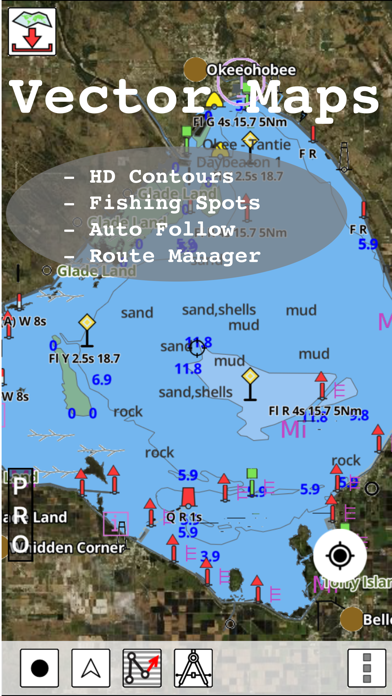
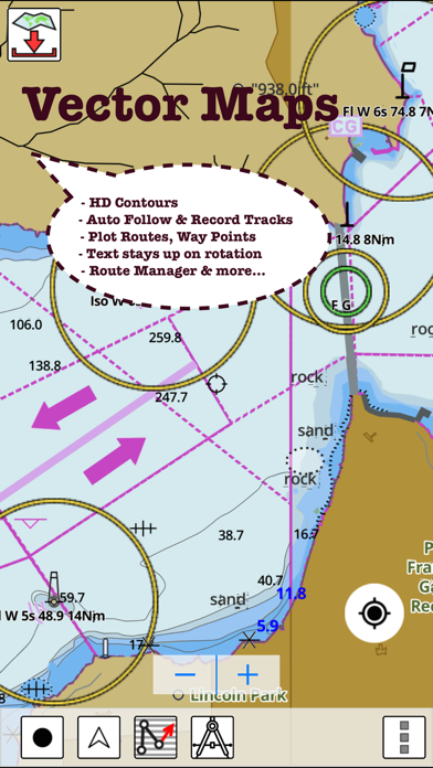
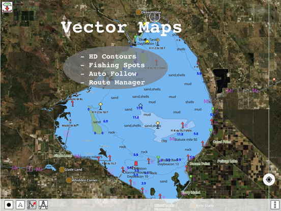
√ Download Beautiful & detailed Hardware/GPU accelerated vector charts (text stays upright on rotation)
√ Query details of Maritime object (Buoy, Lights, Obstruction etc).
√ Custom depth(Ft/Fathom/Meter) & distance units (km/mi/NM)
√ Custom Shallow Depth.
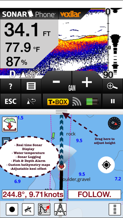
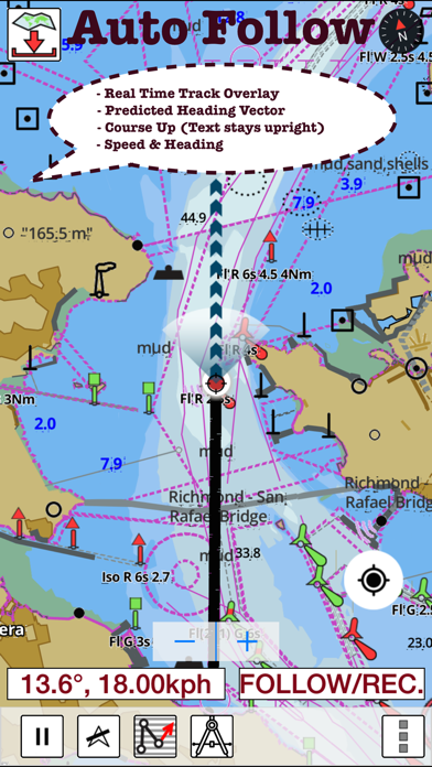
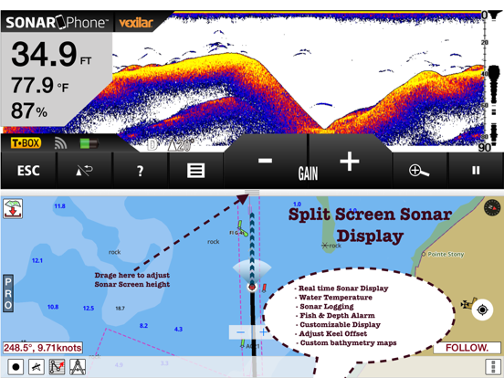
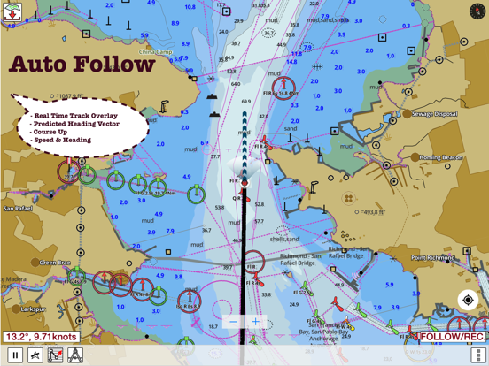
√ Record tracks, Autofollow with real-time track overlay & predicted path vector.
√ Voice Prompts for marine navigation (requires GPS )
√ 1ft / 3ft depth contour maps for anglers for selected lake maps. Useful for fishing/trolling(freshwater/saltwater).
√ Supports GPX/KML for boating route editing/import.
√ Tide & Currents.
√ Seamless chart quilting. Map details from Coastal, Approaches,Harbour, Inland Encs(rivers), and general ENC (Electronic Marine Charts) are automatically mapped to correct zoomlevel
√ Enter / import Waypoints.
► MAPS
Get all the details that you find in your chartplotters!
The maps include coverage of coast of South Africa (derived from SANHO data).
►ROUTE MANAGEMENT / TRIP PLANNING
√ Create New /Edit Routes
√ Reverse Routes
√ Enter,Move, Add, Delete, Rename Waypoints
√ Import GPX, KML & KMZ files
√ Plot/Edit Routes
√ Share/Export Routes, Tracks & Markers
►GPS FEATURES
√ Auto Follow
* Real Time Track Overlay
* Predicted Path Vector
* Course Up (Text stays upright)
* Speed & Heading
√ Route Assistance With Voice Prompts
* Prompts when approaching a boating route marker
* Continous distance & ETA updates
* Alerts when sailing/boating off route
* Alerts when boating in wrong direction
√ Record Tracks
►TIDE & CURRENTS
* For US, Canada, UK,Germany&New Zealand
* High/Low Tides
* Tidal Current Prediction
* Active Current Stations
► SHARING
* Share tracks/routes/markers on Facebook & Twitter
* Export tracks/routes/markers as compressed GPX files.
Sample Maps (See http://goo.gl/IoQsog for full list)
A East London
Agulhas Plateau to Discovery Seamounts
A Lambert's Bay
A Port Elizabeth
Approaches to Durban
Approaches to East London
Approaches to Luderitz
Approaches to Mossel Bay
Approaches to Port Elizabeth
Approaches to Richards Bay
Approaches to Saldanha Bay
Approaches to Table Bay
Approaches to Walvis Bay
A Walvis Bay Harbour
Baia dos Tigres to Conception Bay
B Bird Island Passage
B Oranjemund
Bouvetoya
Cape Agulhas to Cape St Blaize
Cape Columbine to Cape Seal
Cape Columbine to Table Bay
Cape Cross to Conception Bay
Cape Deseada to Table Bay
Cape S. Blaize to Port S. Johns
Cape St Blaize to Cape St Francis
Cape St Francis to Great Fish Point
Chamais Bay to Port Nolloth
C Hondeklipbaai
Conception Point to Hottentot Point
D Port Nolloth
Durban Harbour
Durban to Cape Vidal
E Alexander Bay
East London to Port S Johns
Edinburgh Anchorage
Gough Island
Great Fish Point to Mbashe Point
Green Point to Tongaat Bluff
Hollandsbird Island to Cape Columbine
Hottentot Point to Chamais Bay
House Bay Dasseneiland
Island Point to Cape Deseada
Jesser Point to Boa Paz
Kunene River to Sand Table Hill
Luderitz
Mbashe Point to Maputo
Mossel Bay
Murrays Bay Harbour
Ngqura Harbour
Ponta Grossa to Kunene River
Port Nolloth to Island Point
Port Shepstone to Cooper Light
Port S Johns to Port Shepstone
Port St John's to Durban
Richards Bay Harbour
Saldanha Bay
Saldanha Bay Harbour
Sand Table Hill to Cape Cross
Shixini Point to Port S Johns
Simon's Bay
Table Bay
Table Bay to Cape Agulhas
Table Bay to Valsbaai
Tristan da Cunha Group
Tugela River to Ponta do Ouro
Please Note: “Continued use of GPS running in the background can dramatically decrease battery life.”
►FEATURES
√ Download Beautiful & detailed Hardware/GPU accelerated vector charts (text stays upright on rotation)
√ Query details of Maritime object (Buoy, Lights, Obstruction etc).
√ Custom depth(Ft/Fathom/Meter) & distance units (km/mi/NM)
√ Custom Shallow Depth.
√ Record tracks, Autofollow with real-time track overlay & predicted path vector.
√ Voice Prompts for marine navigation (requires GPS )
√ 1ft / 3ft depth contour maps for anglers for selected lake maps. Useful for fishing/trolling(freshwater/saltwater).
√ Supports GPX/KML for boating route editing/import.
√ Tide & Currents.
√ Seamless chart quilting. Map details from Coastal, Approaches,Harbour, Inland Encs(rivers), and general ENC (Electronic Marine Charts) are automatically mapped to correct zoomlevel
√ Enter / import Waypoints.
► MAPS
Get all the details that you find in your chartplotters!
The maps include coverage of coast of South Africa (derived from SANHO data).
►ROUTE MANAGEMENT / TRIP PLANNING
√ Create New /Edit Routes
√ Reverse Routes
√ Enter,Move, Add, Delete, Rename Waypoints
√ Import GPX, KML & KMZ files
√ Plot/Edit Routes
√ Share/Export Routes, Tracks & Markers
►GPS FEATURES
√ Auto Follow
* Real Time Track Overlay
* Predicted Path Vector
* Course Up (Text stays upright)
* Speed & Heading
√ Route Assistance With Voice Prompts
* Prompts when approaching a boating route marker
* Continous distance & ETA updates
* Alerts when sailing/boating off route
* Alerts when boating in wrong direction
√ Record Tracks
►TIDE & CURRENTS
* For US, Canada, UK,Germany&New Zealand
* High/Low Tides
* Tidal Current Prediction
* Active Current Stations
► SHARING
* Share tracks/routes/markers on Facebook & Twitter
* Export tracks/routes/markers as compressed GPX files.
Sample Maps (See http://goo.gl/IoQsog for full list)
A East London
Agulhas Plateau to Discovery Seamounts
A Lambert's Bay
A Port Elizabeth
Approaches to Durban
Approaches to East London
Approaches to Luderitz
Approaches to Mossel Bay
Approaches to Port Elizabeth
Approaches to Richards Bay
Approaches to Saldanha Bay
Approaches to Table Bay
Approaches to Walvis Bay
A Walvis Bay Harbour
Baia dos Tigres to Conception Bay
B Bird Island Passage
B Oranjemund
Bouvetoya
Cape Agulhas to Cape St Blaize
Cape Columbine to Cape Seal
Cape Columbine to Table Bay
Cape Cross to Conception Bay
Cape Deseada to Table Bay
Cape S. Blaize to Port S. Johns
Cape St Blaize to Cape St Francis
Cape St Francis to Great Fish Point
Chamais Bay to Port Nolloth
C Hondeklipbaai
Conception Point to Hottentot Point
D Port Nolloth
Durban Harbour
Durban to Cape Vidal
E Alexander Bay
East London to Port S Johns
Edinburgh Anchorage
Gough Island
Great Fish Point to Mbashe Point
Green Point to Tongaat Bluff
Hollandsbird Island to Cape Columbine
Hottentot Point to Chamais Bay
House Bay Dasseneiland
Island Point to Cape Deseada
Jesser Point to Boa Paz
Kunene River to Sand Table Hill
Luderitz
Mbashe Point to Maputo
Mossel Bay
Murrays Bay Harbour
Ngqura Harbour
Ponta Grossa to Kunene River
Port Nolloth to Island Point
Port Shepstone to Cooper Light
Port S Johns to Port Shepstone
Port St John's to Durban
Richards Bay Harbour
Saldanha Bay
Saldanha Bay Harbour
Sand Table Hill to Cape Cross
Shixini Point to Port S Johns
Simon's Bay
Table Bay
Table Bay to Cape Agulhas
Table Bay to Valsbaai
Tristan da Cunha Group
Tugela River to Ponta do Ouro
Please Note: “Continued use of GPS running in the background can dramatically decrease battery life.”
 このアプリはiPhone、iPadの両方に対応しています。
カテゴリー
ナビゲーション
ナビゲーション
リリース
2016/1/4
2016/1/4
更新
2022/6/25
2022/6/25
バージョン
122.0.0
122.0.0
言語
サイズ
61.7 MB
61.7 MB
条件
このバージョンの新機能
- Compiled with latest version of Xcode
- Auto Routing Support
- Compiled with latest version of Xcode
- Auto Routing Support
スクリーンショット - iPhone | iPad
スクリーンショット - iPhone | iPad
Bist LLC の他のアプリ » もっと見る
» 目的別iPhoneアプリ検索
- 辞書 » 日本語対応の辞書 » 英和辞典
- 学習 » 英単語 » 英会話 » クイズで楽しく
- スケジュール » 管理 » Googleカレンダー


Yahoo!乗換案内
Yahoo Japan Corp.無料
Google マップ - ナビ、乗換案内
Google LLC無料
Yahoo!カーナビ
Yahoo Japan Corp.無料
乗換NAVITIME(乗換ナビタイム) - 運行情報や路線図..
NAVITIME JAPAN CO.,LTD.無料
Yahoo! MAP-ヤフーマップ
Yahoo Japan Corp.無料
乗換案内
Jorudan Co.,Ltd.無料
賃貸物件検索 SUUMO(スーモ)でお部屋探し
Recruit Co.,Ltd.無料
NAVITIME(乗換と地図の総合ナビ)
NAVITIME JAPAN CO.,LTD.無料
NAVITIMEドライブサポーター - カーナビ&渋滞情報&..
NAVITIME JAPAN CO.,LTD.無料
お部屋探しはライフルホームズ賃貸・マンション・不動産物件検索
LIFULL Co., Ltd無料


CatchApp新着アプリレビュー
 日本縦断てつどうの旅」")
様々な楽しみ方で運転士として成長していく鉄道運転士育成RPG「プラチナ・トレイン(プラトレ) 日本縦断てつどうの旅」
2016-05-17 00:00

日本語にはない英語発音のリスニングを楽しく学べる「発音どっち?英語リスニング 」
2014-12-20 12:00

指先の瞬発力が試されるカジュアルゲーム「早撃ちパニック」をリリース!
2014-12-08 15:21
新着アプリ動画
-
 ¥1500
¥1500
-
 ¥600
¥600
-
 ¥3000
¥3000