


このアプリのYoutube動画がある場合はURLを送信してください。詳細 »
APPLICATION INFO - iPhoneアプリの詳細情報
This App offers offline nautical charts, lake & river navigation maps covering inland rivers & waterways in Europe for fishing, kayaking, boating and sailing. First marine GPS app to have route assistance with Voice Prompts for marine navigation. You can create new boating routes or import existing GPX/KML routes. It supports Nautical Charts course up orientation. Includes Tide & Currents prediction.
►FEATURES
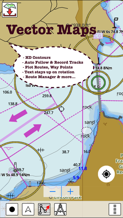
√ Beautiful and detailed Hardware/GPU accelerated vector charts (text stays upright on rotation)
√ Query details of Marine object (Buoy, Lights, Obstruction etc).
√ Customizable depth(Ft/Fathom/Meter) and distance units (km/mi/NM)
√ Customizable Shallow Depth.
√ Record tracks, Autofollow with real-time track overlay & predicted path vector.
√ Voice Prompts for marine navigation (requires GPS )
√ 1ft / 3ft depth contour maps for anglers for selected lake maps.
√ Supports GPX/KML for boating route editing/import.
√ Tide & Currents prediction.
√ Seamless chart quilting. Map details from Coastal, Approaches,Harbour, Inland Encs(rivers), and general ENC charts are automatically mapped to correct zoomlevel
√ Enter or import Waypoints.
► MAPS
Get all the details that you find in your chart plotters!
(More regions are added every week) Please check website. Includes unlimited updates for 1 year.
Europe Inland Rivers & Waterways: Donau/Danube/Dunaja,Rhine,Rhein,Garonne,Moselle,Drava,Sava,etc.
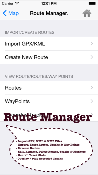
►ROUTE MANAGEMENT / TRIP PLANNING
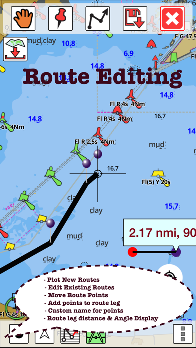
√ Create New Route/Edit Routes
√ Reverse Routes
√ Enter,Move, Add, Delete, Rename Waypoints
√ Import GPX, KML & KMZ files
√ Plot/Edit Routes
√ Share/Export Routes, Tracks & Markers
►GPS FEATURES
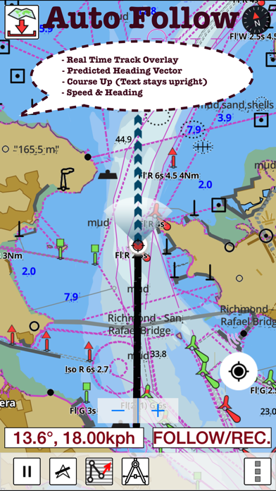
√ Auto Follow
* Real Time Track Overlay
* Predicted Path Vector
* Course Up (Text stays upright)
* Speed & Heading
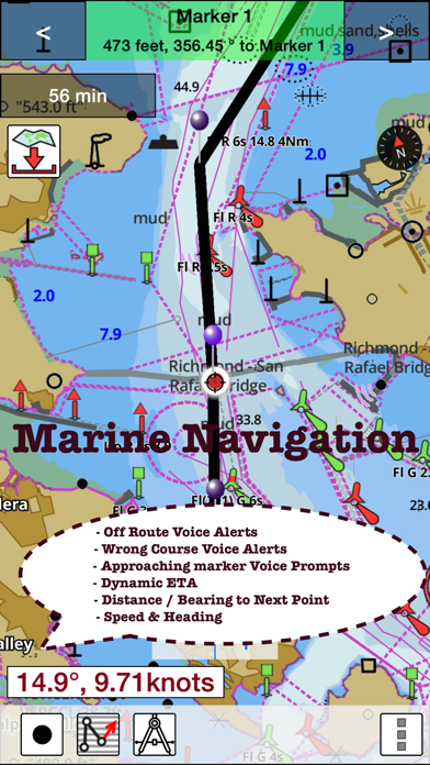
√ Route Assistance With Voice Prompts
* Prompts when approaching a boating route marker
* Continous distance & ETA updates
* Alerts when sailing/boating off route
* Alerts when boating in wrong direction
√ Record Tracks
►TIDE & CURRENTS
* For US, Canada, UK,Germany&New Zealand
* High/Low Tides
* Tidal Current Prediction
* Active Current Stations
► SHARING
* Share tracks/routes/markers on Facebook & Twitter
* Export tracks/routes/markers as compressed GPX files.
*Austria - Donau
*Belgium - Rupel, Netekanaal, Ringvaart om Gent, Schelde-Rijnverbinding, Dijle, Kanaal naar Charleroi, Beneden Zeeschelde, Bocholt-Herentals, Gent-Terneuzen, van Zeebrugge Achterhaven-inclusief het Boudewijnkanaal-tot en met haven Brugge, Zuid-Willemsvaart, Antwerpen Haven, Moervaart, Beneden-Nete, Dessel-Kwaadmechelen, Estuaire Vaart van Zeebrugge tot aan de Nederlandse Grens, Leie, Oostende Plassendalekanaal, Boven-Schelde, Vlaanderen, Zeekanaal, Albertkanaal, Oostende Haven met de 5-mijlszone Estuaire Vaart, Zeeschelde,
*Bulgaria
*Switzerland - Rhine
*Czech Republic - Roudnice nad Labem, Kly, Lovosice, Libotenice, Kostelec nad Labem, Melnik, Hraz Slapske prehrady, Praha - Holesovice, Steti, Libcice nad Vltavou, Praha - Modrany, Podebrady, Usti nad Labem, Veltruby, Melnik - soutok, Vrane nad Vltavou, Chvaletice, Vranany, Hradistko, Dolni Zleb, Neratovice, Celakovice, Statni hranice CR - SRN, Nymburk, Brna nad Labem, Brandys nad Labem, Kralupy nad Vltavou, Litomerice, Hradistko, Male Brezno, Roztoky, Kolin, Decin,
*Germany - Elbe, Westoder, Ruhr, Rhein-Herne-Kanal, Untere Havel-Wasserstraße (Spandau - Plaue), Weser, Neckar, Berlin-Spandauer-Schifffahrtskanal, Donau, Rhein, Spree-Oder-Wasserstraße, Havel-Oder-Wasserstraße, Main-Donau-Kanal, Wesel-Datteln-Kanal, Elbe-Havel-Kanal, Dortmund-Ems-Kanal, Elbe-Seitenkanal, Mittellandkanal, Mosel, Main, Saar
*France - GRANDE SAONE, MOSELLE CANALISEE, LIAISON DUNKERQUE ESCAUT, GARONNE
*Croatia - DRAVA, DANUBE, SAVA
*Hungary - Danube
*Netherlands
*Romania - Maritime Danube, Sulina Channel, Danube Black Sea Channel
*Serbia - Danube, Sava, Tisa
*Slovakia - Dunaja / Danube
Please Note: "Continued use of GPS running in the background
can dramatically decrease battery life."
►FEATURES
√ Beautiful and detailed Hardware/GPU accelerated vector charts (text stays upright on rotation)
√ Query details of Marine object (Buoy, Lights, Obstruction etc).
√ Customizable depth(Ft/Fathom/Meter) and distance units (km/mi/NM)
√ Customizable Shallow Depth.
√ Record tracks, Autofollow with real-time track overlay & predicted path vector.
√ Voice Prompts for marine navigation (requires GPS )
√ 1ft / 3ft depth contour maps for anglers for selected lake maps.
√ Supports GPX/KML for boating route editing/import.
√ Tide & Currents prediction.
√ Seamless chart quilting. Map details from Coastal, Approaches,Harbour, Inland Encs(rivers), and general ENC charts are automatically mapped to correct zoomlevel
√ Enter or import Waypoints.
► MAPS
Get all the details that you find in your chart plotters!
(More regions are added every week) Please check website. Includes unlimited updates for 1 year.
Europe Inland Rivers & Waterways: Donau/Danube/Dunaja,Rhine,Rhein,Garonne,Moselle,Drava,Sava,etc.
►ROUTE MANAGEMENT / TRIP PLANNING
√ Create New Route/Edit Routes
√ Reverse Routes
√ Enter,Move, Add, Delete, Rename Waypoints
√ Import GPX, KML & KMZ files
√ Plot/Edit Routes
√ Share/Export Routes, Tracks & Markers
►GPS FEATURES
√ Auto Follow
* Real Time Track Overlay
* Predicted Path Vector
* Course Up (Text stays upright)
* Speed & Heading
√ Route Assistance With Voice Prompts
* Prompts when approaching a boating route marker
* Continous distance & ETA updates
* Alerts when sailing/boating off route
* Alerts when boating in wrong direction
√ Record Tracks
►TIDE & CURRENTS
* For US, Canada, UK,Germany&New Zealand
* High/Low Tides
* Tidal Current Prediction
* Active Current Stations
► SHARING
* Share tracks/routes/markers on Facebook & Twitter
* Export tracks/routes/markers as compressed GPX files.
*Austria - Donau
*Belgium - Rupel, Netekanaal, Ringvaart om Gent, Schelde-Rijnverbinding, Dijle, Kanaal naar Charleroi, Beneden Zeeschelde, Bocholt-Herentals, Gent-Terneuzen, van Zeebrugge Achterhaven-inclusief het Boudewijnkanaal-tot en met haven Brugge, Zuid-Willemsvaart, Antwerpen Haven, Moervaart, Beneden-Nete, Dessel-Kwaadmechelen, Estuaire Vaart van Zeebrugge tot aan de Nederlandse Grens, Leie, Oostende Plassendalekanaal, Boven-Schelde, Vlaanderen, Zeekanaal, Albertkanaal, Oostende Haven met de 5-mijlszone Estuaire Vaart, Zeeschelde,
*Bulgaria
*Switzerland - Rhine
*Czech Republic - Roudnice nad Labem, Kly, Lovosice, Libotenice, Kostelec nad Labem, Melnik, Hraz Slapske prehrady, Praha - Holesovice, Steti, Libcice nad Vltavou, Praha - Modrany, Podebrady, Usti nad Labem, Veltruby, Melnik - soutok, Vrane nad Vltavou, Chvaletice, Vranany, Hradistko, Dolni Zleb, Neratovice, Celakovice, Statni hranice CR - SRN, Nymburk, Brna nad Labem, Brandys nad Labem, Kralupy nad Vltavou, Litomerice, Hradistko, Male Brezno, Roztoky, Kolin, Decin,
*Germany - Elbe, Westoder, Ruhr, Rhein-Herne-Kanal, Untere Havel-Wasserstraße (Spandau - Plaue), Weser, Neckar, Berlin-Spandauer-Schifffahrtskanal, Donau, Rhein, Spree-Oder-Wasserstraße, Havel-Oder-Wasserstraße, Main-Donau-Kanal, Wesel-Datteln-Kanal, Elbe-Havel-Kanal, Dortmund-Ems-Kanal, Elbe-Seitenkanal, Mittellandkanal, Mosel, Main, Saar
*France - GRANDE SAONE, MOSELLE CANALISEE, LIAISON DUNKERQUE ESCAUT, GARONNE
*Croatia - DRAVA, DANUBE, SAVA
*Hungary - Danube
*Netherlands
*Romania - Maritime Danube, Sulina Channel, Danube Black Sea Channel
*Serbia - Danube, Sava, Tisa
*Slovakia - Dunaja / Danube
Please Note: "Continued use of GPS running in the background
can dramatically decrease battery life."
 このアプリはiPhone、iPadの両方に対応しています。
カテゴリー
ナビゲーション
ナビゲーション
リリース
2016/1/11
2016/1/11
バージョン
52.0.0
52.0.0
言語
サイズ
41.1 MB
41.1 MB
条件
スクリーンショット - iPhone | iPad
スクリーンショット - iPhone | iPad
Bist LLC の他のアプリ » もっと見る
» 目的別iPhoneアプリ検索
- 辞書 » 日本語対応の辞書 » 英和辞典
- 学習 » 英単語 » 英会話 » クイズで楽しく
- スケジュール » 管理 » Googleカレンダー


Yahoo!乗換案内
Yahoo Japan Corp.無料
Google マップ - ナビ、乗換案内
Google LLC無料
Yahoo!カーナビ
Yahoo Japan Corp.無料
乗換NAVITIME(乗換ナビタイム) - 運行情報や路線図..
NAVITIME JAPAN CO.,LTD.無料
Yahoo! MAP-ヤフーマップ
Yahoo Japan Corp.無料
乗換案内
Jorudan Co.,Ltd.無料
賃貸物件検索 SUUMO(スーモ)でお部屋探し
Recruit Co.,Ltd.無料
NAVITIME(乗換と地図の総合ナビ)
NAVITIME JAPAN CO.,LTD.無料
NAVITIMEドライブサポーター - カーナビ&渋滞情報&..
NAVITIME JAPAN CO.,LTD.無料
お部屋探しはライフルホームズ賃貸・マンション・不動産物件検索
LIFULL Co., Ltd無料


CatchApp新着アプリレビュー
 日本縦断てつどうの旅」")
様々な楽しみ方で運転士として成長していく鉄道運転士育成RPG「プラチナ・トレイン(プラトレ) 日本縦断てつどうの旅」
2016-05-17 00:00

日本語にはない英語発音のリスニングを楽しく学べる「発音どっち?英語リスニング 」
2014-12-20 12:00

指先の瞬発力が試されるカジュアルゲーム「早撃ちパニック」をリリース!
2014-12-08 15:21
新着アプリ動画
-
 ¥1500
¥1500
-
 ¥600
¥600
-
 ¥3000
¥3000