


このアプリのYoutube動画がある場合はURLを送信してください。詳細 »
APPLICATION INFO - iPhoneアプリの詳細情報
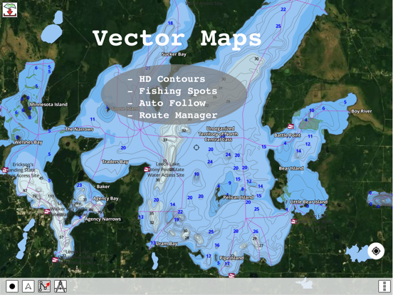
GPS Nautical Charts App offers access to RNC charts covering United Kingdom / Ireland waters (derived from UKHO data) with POI layers created from ENC charts. Only marine GPS app to have route assistance with Voice Prompts for marine navigation. It has route manager to create new boating routes or import existing GPX/KML routes. It supports Nautical Charts course up orientation.
Please visit http://www.gpsnauticalcharts.com/main/uk-nautical-charts-by-folio.html for complete list. If you don't find the chart for United Kingdom / Ireland, please contact us at support at gpsnauticalcharts.com.
* Voice Prompts for marine navigation (requires GPS )
-prompts when approaching a boating route marker
-Continous distance and ETA updates
-Alerts when sailing/boating off route
-Alerts when boating in wrong direction
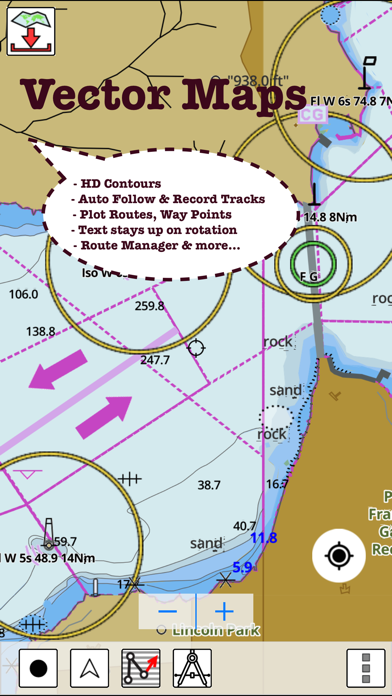
*Route Editing/Creation
-Create routes from scratch
-Edit existing GPX/KML routes.
-Add custom description to any route point.
-Drop markers along route.
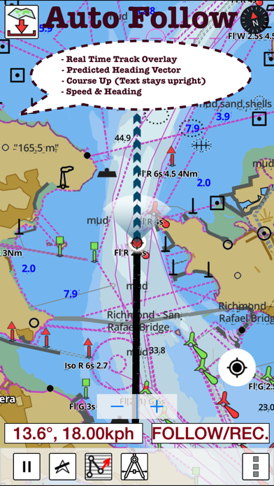
*Real time track overlay with projected heading vector
* Offline charts derived from UKHO data.
-Visually draw area to download
-Textual search
-Catalog (By state, region and coast guard district)
-Charts reprojected for WGS84 datum
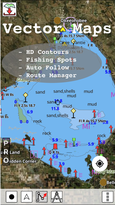
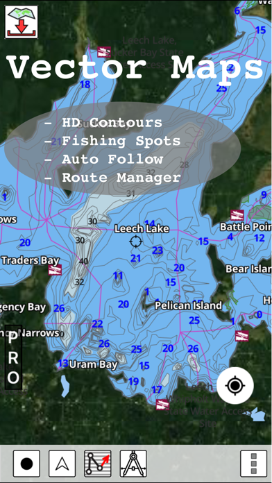
*Seamless chart quilting of marine charts
*Distance Bearing tool
*Create custom way points
- Using GPS
-Select point on map
-Manually enter latitude & longitude coordinates
*POI layer for marine charts
- Overlay POIs
- POI list derived from the equivalent ENC and contains all categories including Buoy, Light, Harbour facility, Obstr.
*Search POIs/Way points
*Tidal Prediction
*Pan/Zoom/My Location
* Record Marine GPS tracks
* View tracks overlay
* Live track animation
* Track analytics/stats
* Export GPX tracks.
-Export to SDCard
-Share GPX trakcs with friends.
* Auto Follow Mode (Course up)
-Continuously updates boat's location on chart
- Adjustable update frequency
Sample Nautical Charts (please visit http://www.gpsnauticalcharts.com/main/uk-nautical-charts-by-folio.html for complete list)
The Solent and Southampton Water
A Beaulieu River
Western Approaches to The Solent
Approaches to Portsmouth
Bill of Portland to the Needles
Bill of Portland to Anvil Point
Eastern Approaches to the Solent
G Lymington River
A Continuation of River Medina
Southampton Water and Approaches
Outer Approaches to the Solent
Port of Southampton
Selsey Bill to Beachy Head
Approaches to Portland and Weymouth
Cowes Harbour and River Medina
Berry Head to Bill of Portland
Entrance to River Hamble
Thames Estuary
B River Medina Folly Point to Newport
Portsmouth Harbour
Ashlett Creek
Yarmouth Harbour
Approaches to Keyhaven
Alum Bay
Newtown River
Approaches to Felixstowe, Harwich and Ipswich with the Rivers Stour, Orwell and Deben
Falmouth to Plymouth
G Hillhead Harbour
Dartmouth Harbour
Poole Harbour and Approaches
Poole Bay
Falmouth to Truro
B Upper Reaches of Beaulieu River
Continuation of Fareham Lake
River Yar
Wootton Creek
Langstone and Chichester Harbours
Lyme Regis Harbour
Brighton Marina
Land's End to Falmouth
Portsmouth Harbour Southern Part
Bembridge Harbour
Continuation of Holes Bay
Eddystone Rocks to Berry Head
Approaches to Padstow
Thames Estuary Northern Part
Freshwater Bay
Helford River Continuation to Gweek
Tor Bay
Portsmouth Harbour Northern Part
Lizard Point
Continuation to Port Solent
Start Point to Brixham
Continuation to Blackness Point
Newquay Bay
Salcombe to Start Point
Charlestown Harbour
Portland Harbour
River Thames Sea Reach
Penzance Bay
Caernarfon Bay
Bristol Channel
Mevagissey
Linney Head to Oxwich Point
Salcombe Harbour
Harwich and Felixstowe
Salcombe
Approaches to Falmouth
Par Harbour
PLEASE NOTE: Continued use of GPS running in the background can dramatically decrease battery life.
Please visit http://www.gpsnauticalcharts.com/main/uk-nautical-charts-by-folio.html for complete list. If you don't find the chart for United Kingdom / Ireland, please contact us at support at gpsnauticalcharts.com.
* Voice Prompts for marine navigation (requires GPS )
-prompts when approaching a boating route marker
-Continous distance and ETA updates
-Alerts when sailing/boating off route
-Alerts when boating in wrong direction
*Route Editing/Creation
-Create routes from scratch
-Edit existing GPX/KML routes.
-Add custom description to any route point.
-Drop markers along route.
*Real time track overlay with projected heading vector
* Offline charts derived from UKHO data.
-Visually draw area to download
-Textual search
-Catalog (By state, region and coast guard district)
-Charts reprojected for WGS84 datum
*Seamless chart quilting of marine charts
*Distance Bearing tool
*Create custom way points
- Using GPS
-Select point on map
-Manually enter latitude & longitude coordinates
*POI layer for marine charts
- Overlay POIs
- POI list derived from the equivalent ENC and contains all categories including Buoy, Light, Harbour facility, Obstr.
*Search POIs/Way points
*Tidal Prediction
*Pan/Zoom/My Location
* Record Marine GPS tracks
* View tracks overlay
* Live track animation
* Track analytics/stats
* Export GPX tracks.
-Export to SDCard
-Share GPX trakcs with friends.
* Auto Follow Mode (Course up)
-Continuously updates boat's location on chart
- Adjustable update frequency
Sample Nautical Charts (please visit http://www.gpsnauticalcharts.com/main/uk-nautical-charts-by-folio.html for complete list)
The Solent and Southampton Water
A Beaulieu River
Western Approaches to The Solent
Approaches to Portsmouth
Bill of Portland to the Needles
Bill of Portland to Anvil Point
Eastern Approaches to the Solent
G Lymington River
A Continuation of River Medina
Southampton Water and Approaches
Outer Approaches to the Solent
Port of Southampton
Selsey Bill to Beachy Head
Approaches to Portland and Weymouth
Cowes Harbour and River Medina
Berry Head to Bill of Portland
Entrance to River Hamble
Thames Estuary
B River Medina Folly Point to Newport
Portsmouth Harbour
Ashlett Creek
Yarmouth Harbour
Approaches to Keyhaven
Alum Bay
Newtown River
Approaches to Felixstowe, Harwich and Ipswich with the Rivers Stour, Orwell and Deben
Falmouth to Plymouth
G Hillhead Harbour
Dartmouth Harbour
Poole Harbour and Approaches
Poole Bay
Falmouth to Truro
B Upper Reaches of Beaulieu River
Continuation of Fareham Lake
River Yar
Wootton Creek
Langstone and Chichester Harbours
Lyme Regis Harbour
Brighton Marina
Land's End to Falmouth
Portsmouth Harbour Southern Part
Bembridge Harbour
Continuation of Holes Bay
Eddystone Rocks to Berry Head
Approaches to Padstow
Thames Estuary Northern Part
Freshwater Bay
Helford River Continuation to Gweek
Tor Bay
Portsmouth Harbour Northern Part
Lizard Point
Continuation to Port Solent
Start Point to Brixham
Continuation to Blackness Point
Newquay Bay
Salcombe to Start Point
Charlestown Harbour
Portland Harbour
River Thames Sea Reach
Penzance Bay
Caernarfon Bay
Bristol Channel
Mevagissey
Linney Head to Oxwich Point
Salcombe Harbour
Harwich and Felixstowe
Salcombe
Approaches to Falmouth
Par Harbour
PLEASE NOTE: Continued use of GPS running in the background can dramatically decrease battery life.
 このアプリはiPhone、iPadの両方に対応しています。
カテゴリー
旅行
旅行
リリース
2013/8/9
2013/8/9
更新
2019/4/20
2019/4/20
バージョン
85.0.0
85.0.0
言語
サイズ
56.7 MB
56.7 MB
条件
このバージョンの新機能
- Compiled with latest version of Xcode
- Incorporated feedback from customers
- Online maps are now default. (Offline still supported incl. strict offline mode)
- Plan routes using online maps and then download just cell covering your cruising area.
- Compiled with latest version of Xcode
- Incorporated feedback from customers
- Online maps are now default. (Offline still supported incl. strict offline mode)
- Plan routes using online maps and then download just cell covering your cruising area.
スクリーンショット - iPhone | iPad
スクリーンショット - iPhone | iPad
Bist LLC の他のアプリ » もっと見る
» 目的別iPhoneアプリ検索
- 辞書 » 日本語対応の辞書 » 英和辞典
- 学習 » 英単語 » 英会話 » クイズで楽しく
- スケジュール » 管理 » Googleカレンダー


Google Earth
Google LLC無料
じゃらん
Recruit Co.,Ltd.無料
楽天トラベル
Rakuten Travel Inc.無料
ホテルズドットコム - 国内・海外のホテルをお得に予約
Hotels.com無料
ANA
ANA (All Nippon Airways)無料
アトラクション待ち時間
NORIHIKO HAYASAKA無料
エクスペディア - ホテル予約、格安航空券&現地ツアー予約
Expedia, Inc.無料
まっぷるリンク
Shobunsha Publications, Inc.無料
週刊じゃらん -旬の観光・グルメ・宿情報をまとめ読み
Recruit Co.,Ltd.無料
ホテル予約 厳選20社 旅比較ねっと
BIGLOBE Inc.無料


CatchApp新着アプリレビュー
 日本縦断てつどうの旅」")
様々な楽しみ方で運転士として成長していく鉄道運転士育成RPG「プラチナ・トレイン(プラトレ) 日本縦断てつどうの旅」
2016-05-17 00:00

日本語にはない英語発音のリスニングを楽しく学べる「発音どっち?英語リスニング 」
2014-12-20 12:00

指先の瞬発力が試されるカジュアルゲーム「早撃ちパニック」をリリース!
2014-12-08 15:21
新着アプリ動画
-
 ¥1500
¥1500
-
 ¥600
¥600
-
 ¥3000
¥3000